.png)
Hyderabad Regional Ring Road (RRR) 2026: Route Map, Villages & What to Verify Before You Buy
A prospective buyer in Hyderabad comes across a glossy marketing brochure promoting "premium RRR-facing residential plots-book before prices double." The hyderabad regional ring road is widely recognized as the largest infrastructure project reshaping Telangana, making the investment appear to be a guaranteed win. The buyer commits capital immediately.
Then the operational realities surface.
First, the plot is situated along the southern arc, where the alignment was only recently finalized, leaving the Detailed Project Report (DPR) and central ministry approvals years behind the northern segment. Worse, an engineering survey reveals the survey number sits directly inside the right-of-way acquisition boundary-meaning the land will be acquired by the government for highway construction rather than developed alongside it. Finally, the "approved layout" turns out to have never received mandatory approval from the Hyderabad Metropolitan Development Authority (HMDA) or Directorate of Town and Country Planning (DTCP).
The RRR Hyderabad corridor is a transformative economic driver. However, buying "land near RRR Hyderabad" can mean completely different things depending on which arc you choose, which side of an interchange you sit on, and how the parcel is registered on the state revenue portal.
Here is your comprehensive 2026 guide to the Regional Ring Road route map, the north versus south status split, key villages in the growth corridor, and the critical due diligence steps required before you buy.
Quick Answer: The Hyderabad Regional Ring Road (RRR) is a proposed ~340 km greenfield, 4-lane access-controlled expressway being developed by the National Highways Authority of India (NHAI) roughly 30 km beyond the existing Outer Ring Road (ORR). The project is divided into two distinct sections: a ~161 km northern section (with land acquisition reported at ~99% notified and pre-construction work moving forward) and a ~182 km southern section (where the alignment was finalized by the State Cabinet under Option 2, but DPR and central approvals remain pending). Land near the RRR offers significant upside, but buyers must verify segment-level execution status, ensure the plot is not inside the acquisition corridor, confirm proximity to an official interchange, and verify HMDA/DTCP approvals, TS-RERA registration, and Dharani title status.
What the Hyderabad RRR Actually Is (And Why It’s Not "ORR-2")
Many retail buyers treat the RRR as a simple outward expansion of the 158 km Nehru Outer Ring Road (ORR). That assumption is flawed. The RRR operates under entirely different planning, jurisdictional, and engineering parameters.
- Greenfield Alignment: Unlike arterial road expansions, the RRR is cut almost entirely through raw agricultural hinterland, linking major satellite towns across multiple districts including Sangareddy, Medak, Siddipet, Yadadri Bhuvanagiri, Ranga Reddy, and Vikarabad.
- Scale and Dimensions: The total project spans approximately 340 km with a proposed ~100-meter Right-of-Way (RoW). It is designed as a 4-lane access-controlled expressway, engineered for 120 km/h speeds and planned for eventual expansion to 8 lanes.
- Execution & Funding Structure: The corridor is executed by the Central Government via NHAI under the Bharatmala Pariyojana / National Highways development program, with the Telangana State Government committing to fund roughly 50% of the land acquisition costs.
- The "Access-Controlled" Reality: Because the RRR is an access-controlled expressway, it is bordered by continuous physical barriers. You cannot simply build a driveway or commercial access point onto the road from an abutting property. Commuters and logistics fleets can enter and exit only at designated, grade-separated interchanges. Land touching the highway fence without an interchange nearby receives almost none of the expressway's transit utility.
North vs. South: The Status Split Most Buyers Miss
The single most critical factor when evaluating whether is it good to buy land near RRR is understanding that the project is not moving forward as a single unified timeline. The corridor is split into two halves operating at entirely different stages of execution.
[ NORTHERN ARC: ~161 km ]
Sangareddy ➔ Toopran ➔ Gajwel ➔ Yadadri ➔ Choutuppal
Status: Advanced | ~99% Land Notified | NH-161AA Notified
────────────────────────────────────────────────────────────
[ SOUTHERN ARC: ~182 km ]
Choutuppal ➔ Ibrahimpatnam ➔ Kandukur ➔ Chevella ➔ Sangareddy
Status: Early Stage | Option-2 Alignment Finalized | DPR / Approvals Pending
1. The Northern Section (~161 km)
Designated as NH-161AA, the northern arc connects Sangareddy, Narsapur, Toopran, Gajwel, Yadadri Bhuvanagiri, and Choutuppal.
- Current Status: This segment is far ahead administratively. Land acquisition across major districts has seen competent authorities publish 3A, 3D, and 3G notifications, with the Ministry of Road Transport and Highways (MoRTH) reporting that roughly 99% of the required land has been notified.
- Investment Horizon: Near-to-medium term. Civil construction tenders and ground packages are positioned to commence significantly earlier than the southern loop.
2. The Southern Section (~182 km)
The southern arc traces Choutuppal, Ibrahimpatnam, Kandukur, Amangal, Chevella, Shankarpally, and loops back into Sangareddy.
- Current Status: The southern segment has faced repeated alignment adjustments. The Telangana State Cabinet recently approved a revised alignment (favoring the Option-2 route that adjusts trajectories around the Rajapur / Manneguda / Shadnagar belt to better integrate with proposed regional manufacturing nodes).
- Investment Horizon: Long-term. Because final Detailed Project Reports (DPR), financial sanctions, and central environmental clearances remain pending, ground execution on the south is several years behind the north.
Buyer Caution: Never accept marketing claims stating that "the entire RRR will open simultaneously." Investment holding periods must be calibrated to the specific arc.
The Route: RRR Villages and Towns Set to Grow
The regional ring road route map intersects key national and state highways radiating out of Hyderabad, creating high-value logistics, warehousing, and commercial satellite clusters at major junction points.
Northern Arc Villages and Anchor Towns
The northern section passes through dozens of revenue villages across Sangareddy, Medak, Siddipet, and Yadadri Bhuvanagiri:
- Sangareddy Junction: Connects to NH-65 (Pune–Hyderabad Highway). Acts as an industrial manufacturing anchor with proximity to IIT Hyderabad and Kandi.
- Narsapur: Intersects State Highway 19 (SH-19). Key villages in this belt are seeing significant plotted development activity.
- Toopran: Major crossing at NH-44 (Nagpur–Hyderabad Highway). High-density industrial logistics corridor with dry port potential.
- Gajwel & Pragnapur: Intersects the Rajiv Rahadari state highway (SH-1). Well-developed regional civic infrastructure.
- Yadadri–Bhongir (Bhuvanagiri): Intersects NH-163 (Hyderabad–Warangal Highway). Benefits from religious tourism infrastructure and outer logistics connectivity.
- Choutuppal: Intersects NH-65 (Hyderabad–Vijayawada Highway). Serves as the junction point connecting the northern and southern arcs.
Southern Arc Villages and Anchor Towns
The southern arc runs through Ranga Reddy, Vikarabad, and Nalgonda districts:
- Ibrahimpatnam: Connects the Nagarjuna Sagar highway. Proximate to major engineering institutions and hardware parks.
- Kandukur: Intersects NH-765 (Hyderabad–Srisailam Highway). Located adjacent to the southern pharma and manufacturing growth zones.
- Amangal & Shadnagar / Rajapur Vicinity: Intersects NH-44 south (Hyderabad–Bengaluru Highway). Key intersection for cross-state freight transit.
- Chevella & Shankarpally: Intersects the Bijapur highway and secondary arteries connecting westward towards the Financial District and Neopolis.
(To understand how the RRR fits into wider metropolitan density shifts, explore our proprietary satellite study on ring road corridor growth).
.png)
The Five Traps Near the RRR
The aggressive marketing surrounding the RRR has created serious pitfalls for retail buyers. Protect your capital by understanding these five common traps:
1. The Acquisition Corridor Trap
The most financially catastrophic mistake. Brokers often sell plots located directly within the proposed 100-meter Right-of-Way or within the footprint of planned interchange loops. When NHAI issues final award declarations, the land is acquired by the government. The buyer receives statutory compensation (often pegged to lower government values) rather than commercial development returns.
2. Access-Controlled ≠ Direct Access
As emphasized, the RRR is designed with perimeter fencing. A plot situated 50 meters from the highway that is 8 kilometers away from an authorized interchange ramp has zero highway utility. Heavy commercial vehicles and daily commuters cannot reach the expressway without long detours through village service roads.
3. Segment-Timing Mismatch
Purchasing land along the southern arc under the impression that it will appreciate at the same rate as the northern arc overlooks administrative reality. While the north moves into structural contracting, the south must navigate complete land acquisition, award inquiries, and central fund allocations.
4. The "LRS / Unapproved Layout" Deception
Speculative developers routinely acquire agricultural acreage near proposed junctions, divide the land with crude boundary stones, and market individual 200-square-yard plots without formal HMDA or DTCP layout sanctions. They assure buyers that the plot can be regularized under the state's Layout Regularization Scheme (LRS). In reality:
- Unapproved layouts face stringent registration restrictions.
- Banks refuse to sanction construction loans on unapproved sites.
- Municipal authorities do not provide basic water, drainage, or electricity connections.
5. NALA Conversion & Section 22A Prohibitions on Dharani
Under Telangana land regulations, raw land is agricultural by default. It cannot be used for plotted residential or commercial development without securing a formal NALA (Non-Agricultural Land Assessment) conversion order.
Furthermore, buyers must thoroughly examine the Dharani portal to ensure the survey number does not fall under the Section 22A list of prohibited properties (which includes government land, assigned lands, endowment properties, and Waqf holdings). Any transaction executed on a 22A-notified survey number is legally void.
How to Verify an RRR Plot (The Due Diligence Checklist)
Before transferring an advance or executing an Agreement to Sell for land near the Regional Ring Road, run through this six-step verification protocol:
(For a nationwide procedural framework on land transactions, consult our comprehensive land due diligence checklist).
Verify Alignment & Growth Layers with TalkingLands Insights
You cannot determine whether a plot is safely outside an acquisition boundary or near a functional junction by looking at an empty agricultural field or a broker's marketing map.
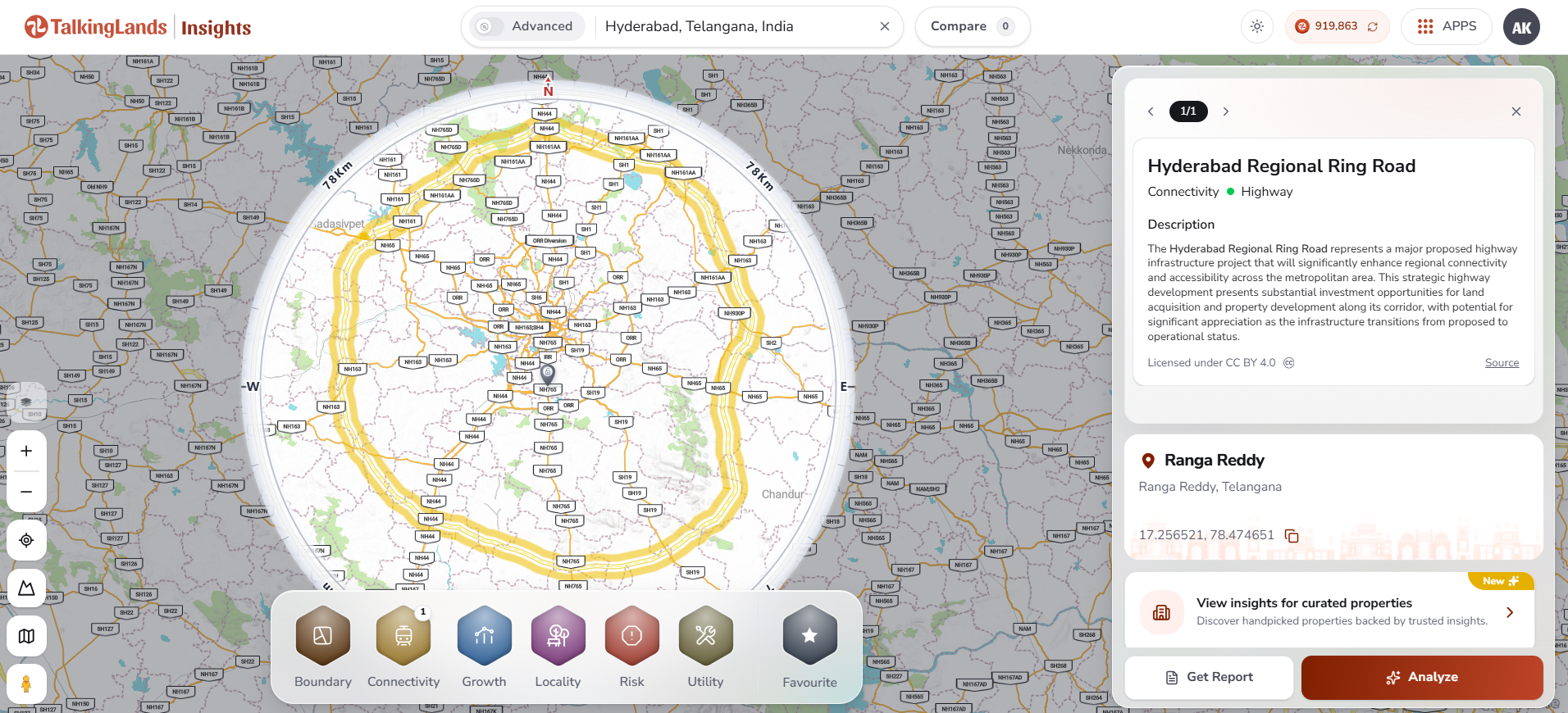
With TalkingLands Insights, verifying regional infrastructure around Hyderabad takes seconds. Drop your targeted coordinates or locality into the platform to visualize the property against active infrastructure grids.
You can toggle the Connectivity Layer to view the mapped trajectory of the Regional Ring Road, trace major national highways (NH-44, NH-65, NH-163), and evaluate surrounding industrial and logistics corridors. You can simultaneously evaluate surrounding environmental and terrain risk layers before committing capital.
(Honesty Note: While TalkingLands Insights provides spatial visibility into the RRR highway alignment, regional connectivity, and surrounding growth layers, always verify localized survey numbers against official NHAI gazette declarations and check title records directly on the Telangana Dharani portal).
-p-2000.png)
Frequently Asked Questions
1. What is the Hyderabad Regional Ring Road (RRR)?
The Hyderabad Regional Ring Road is an upcoming ~340 km, 4-lane access-controlled greenfield expressway encircling the Hyderabad metropolitan region roughly 30 km outside the existing Outer Ring Road. Spearheaded by NHAI, it connects major satellite towns across Telangana to divert heavy interstate freight and spur decentralized industrial growth.
2. What is the RRR route and which villages does it pass?
The northern section passes through towns and villages around Sangareddy, Narsapur, Toopran, Gajwel, Pragnapur, Yadadri-Bhongir, and Choutuppal. The southern section loops from Choutuppal through Ibrahimpatnam, Kandukur, Amangal, Shadnagar/Rajapur vicinity, Chevella, and Shankarpally, terminating back at Sangareddy.
3. What is the status of the RRR north vs south?
The northern arc (~161 km, NH-161AA) is far more advanced, with the central ministry reporting that approximately 99% of required land has been notified under 3A/3D/3G gazettes. The southern arc (~182 km) had its alignment finalized under the Option-2 route by the State Cabinet, but Detailed Project Reports (DPR), financial sanctions, and central environmental clearances are still pending.
4. Is it good to buy land near the Hyderabad RRR?
Yes, but only conditionally. Land situated near approved grade-separated interchanges, possessing formal HMDA or DTCP layout sanctions, TS-RERA registration, and NALA conversion offers strong appreciation potential. Conversely, purchasing land inside the acquisition Right-of-Way or unapproved agricultural layouts carries immense legal and financial risk.
5. What is the RRR acquisition corridor?
The acquisition corridor refers to the designated ~100-meter Right-of-Way (RoW) and interchange land parcels notified by NHAI for highway construction. Any private land falling inside these notified survey numbers will be legally acquired by the government, meaning buyers receive statutory compensation rather than real estate appreciation.
6. How do I verify a plot near the RRR?
To verify a plot, check the survey number against MoRTH/NHAI gazette notifications to ensure it is not marked for acquisition, verify driving distance to the nearest interchange, confirm non-agricultural conversion (NALA) on the Dharani portal, check the Section 22A prohibited property register, and verify approvals from HMDA/DTCP and TS-RERA.
.png)

.png)


