.png)
The Kasturirangan report (officially the High-Level Working Group report of 2013) recommended declaring a massive contiguous stretch of the Western Ghats' natural landscape as a protected Eco-Sensitive Area (ESA). The framework enforces a strict no-development approach for major commercial and industrial projects, while explicitly excluding human settlements, agricultural farmland, and private plantations from severe restrictions. It spans six Indian states (Maharashtra, Karnataka, Tamil Nadu, Kerala, Goa, and Gujarat). Inside the ESA boundary, highly disruptive activities such as mining, quarrying, thermal power generation, and large-scale real estate construction are strictly banned. As of 2026, despite over a decade of intense political debate, the notification remains a heavily contested draft. The Union Government has recently re-issued the seventh draft notification proposing 56,825.7 sq km of the Western Ghats as an Eco-Sensitive Area. This ongoing regulatory limbo makes the ESA a critical, volatile legal overlay for anyone owning, buying, or developing land in the Ghats.
Key Takeaways for Land Buyers and Investors
- The Kasturirangan report isolates roughly 37% of the Western Ghats as a highly protected Eco-Sensitive Area (ESA).
- The proposed ESA boundary encompasses thousands of villages spanning Gujarat, Maharashtra, Goa, Karnataka, Kerala, and Tamil Nadu.
- It serves as a more moderate, pro-farmer alternative to the earlier Gadgil report, intentionally leaving out existing villages and active agricultural zones.
- Banned activities include all new mining, quarrying, sand mining, thermal power plants, and large construction projects exceeding 20,000 sq m.
- The legal notification is still in draft form, with the very first draft originally issued back in March 2014.
- The most recent seventh draft was issued in mid-2026 after the sixth iteration lapsed due to ongoing disagreements between the Ministry of Environment, Forest and Climate Change (MoEFCC) and the six stakeholder states.
- Land located inside the proposed ESA faces severe legal caps on commercial development potential, heavily impacting its market value and viable long-term use cases.
- → The Ecological and Geographical Importance of the Western Ghats
- → Understanding the Western Ghats Eco-Sensitive Area (ESA) Framework
- → The Great Debate: Madhav Gadgil vs. K. Kasturirangan
- → State-by-State Breakdown: The Affected Villages and Shifting Stances
- → The Rules: What is Strictly Banned and What is Permitted in the ESA?
- → A Decade of Delay: From the First to the Seventh Draft Notification
- → Crucial Implications for Real Estate Developers and Land Owners
- → How to Legally Verify if a Plot is Inside the ESA Boundary
The Ecological and Geographical Importance of the Western Ghats
The Western Ghats is a formidable, 1,600-kilometre-long continuous mountain range running parallel to India's western coast. It is recognized globally as one of the world's eight hottest biodiversity hotspots and holds the prestigious title of a UNESCO World Heritage Site. Traversing through Gujarat, Maharashtra, Goa, Karnataka, Kerala, and Tamil Nadu, this magnificent chain of mountains is geologically older than the Himalayas and forms the absolute defining geomorphic feature of the Indian peninsula.
Beyond its exceptionally rich biodiversity—which hosts hundreds of globally threatened and endemic species of flora and fauna, including the endangered lion-tailed macaque, the Nilgiri tahr, and deeply unique ecosystems such as high-altitude Shola forests and ancient Myristica swamps—the Western Ghats act as the primary, irreplaceable watershed for the entire southern peninsula. The dense forests here give rise to major east-flowing and west-flowing river systems such as the Godavari, Krishna, Cauvery, Tungabhadra, and Periyar. These river networks sustain the drinking water, irrigation, and massive hydroelectric needs of nearly 250 million people. Furthermore, the Ghats play a critical meteorological role; the mountain range intercepts the moisture-laden southwest monsoon winds sweeping in from the Arabian Sea, heavily influencing and dictating the climate pattern of the entire Indian subcontinent.
However, decades of unchecked urbanization, rampant illegal mining operations, unscientific stone quarrying, aggressive commercial plantation expansion, and massive linear infrastructure projects have severely fragmented this fragile ecosystem. The increasing frequency of devastating seasonal floods and deadly landslides in vulnerable states like Kerala and Karnataka is a direct, violent symptom of this prolonged ecological degradation. The Eco-Sensitive Area (ESA) regulatory mechanism was introduced specifically as an environmental "shock absorber" to halt this rapid decline and prevent future catastrophic man-made disasters.
Understanding the Western Ghats Eco-Sensitive Area (ESA) Framework
The formal declaration of ESAs is a powerful regulatory measure taken under the Environment (Protection) Act, 1986, which fundamentally empowers the Central Government to protect and improve environmental quality by regulating environmentally harmful developmental activities in designated regions. The core objective of establishing an ESA is not to create a completely human-free, fenced-off zone (as is the case with strictly protected National Parks or core Wildlife Sanctuaries). Rather, the goal is to establish a strategically regulated buffer landscape where highly destructive, large-scale commercial activities are completely prohibited, while traditional, low-impact local livelihoods, sustainable agriculture, and eco-tourism are allowed to continue and thrive.
When the Kasturirangan committee—officially known as the High-Level Working Group (HLWG)—analyzed this vast geographical expanse using advanced satellite imagery and high-resolution remote sensing technology, they recognized the immediate need for a balanced, practical approach. They scientifically divided the entire Western Ghats into two distinctly defined categories:
- The Natural Landscape (approx. 37%): This category comprises biologically rich areas, contiguous pristine forest patches, vital wildlife corridors, and highly sensitive, steep topographies. The committee recommended that this entire natural landscape (roughly 59,940 sq km) be formally declared and locked down as the ESA.
- The Cultural Landscape (approx. 63%): This category represents areas already heavily modified and shaped by human activity over centuries. It includes bustling towns, sprawling agricultural lands, existing rural settlements, and large commercial plantations. The committee emphatically recommended leaving this 63% area completely out of the stringent ESA regulations to protect local economies and prevent massive social upheaval.
This calculated 37/63 split serves as the foundational logic of the entire Kasturirangan report. By focusing severe regulatory firepower only on the absolute most critical, untouched natural landscapes, the report attempted to expertly balance urgent conservation requirements with the complex socioeconomic realities of the millions who call the Ghats their home.
The Great Debate: Madhav Gadgil vs. K. Kasturirangan
In Indian environmental policy, academic debates, and real estate circles, the ongoing regulatory gridlock surrounding the Western Ghats is entirely rooted in the deep philosophical and scientific differences between two landmark commissions: the Gadgil Committee and the Kasturirangan Committee.
The Gadgil Report (2011)
The concept of a formalized ESA for the Western Ghats was first extensively studied and mapped by the Western Ghats Ecology Expert Panel (WGEEP), which was formed in 2010 and chaired by the renowned ecologist Madhav Gadgil. Released in 2011, the highly anticipated Gadgil report took a fiercely protective, ecologically purist stance. The Gadgil Committee recommended a much larger, sweeping area for protection, suggesting that almost the entire Western Ghats (approximately 64% of the region) be declared as an ESA utilizing a localized, bottom-up approach to governance. He geographically divided the region into three distinct Eco-Sensitive Zones (ESZ-1, ESZ-2, and ESZ-3), each carrying varying degrees of strict regulations. ESZ-1 was proposed as virtually a complete no-go area for any new development, including a ban on genetically modified crops and chemical pesticides. Predictably, the report faced immense and immediate backlash from state governments across the political spectrum, as well as local communities, due to deep, widespread concerns over its sweeping development restrictions.
The Kasturirangan Report (2013)
In order to break the escalating political stalemate and find a more socially and economically palatable middle ground, the central government appointed a new High-Level Working Group in 2012, chaired by Dr. K. Kasturirangan, specifically tasked to review the Gadgil report. The Kasturirangan Committee proposed a far more balanced, pragmatic approach by recommending that only about 37% of the Western Ghats be designated as an ESA. Where Gadgil relied on a broad grid-based mapping system that swept up large populations, Kasturirangan utilized precise satellite data to map the terrain down to the specific village level. The most significant policy shift was that Kasturirangan completely abandoned Gadgil's complex three-tiered zoning system. Instead, he drew a hard, binary line between the "natural" and "cultural" landscapes, deliberately excluding inhabited areas, agricultural farmland, and plantations to make the framework far more pro-farmer and development-friendly.
State-by-State Breakdown: The Affected Villages and Shifting Stances
The proposed Kasturirangan ESA is absolutely not a single, continuous, contiguous block; rather, it is a highly complex patchwork of sensitive zones spanning six separate states. The regulatory burden and political fallout fall very unevenly, heavily impacting those states with vast forested tracts and established mining industries.
- Karnataka: The state of Karnataka contains the lion's share of the notified area. In Karnataka alone, a massive area of 20,668 sq km spread across 10 vital districts—including Belagavi, Chamarajanagar, Chikkamagaluru, Kodagu, Hassan, Uttara Kannada, Dakshina Kannada, Mysuru, Shivamogga, and Udupi—were identified for formal declaration as an ESA. Successive state governments have consistently, unanimously opposed the notification to alleviate severe distress caused to farmers and the general public, arguing forcefully that it would permanently freeze regional infrastructure projects and devastate agricultural livelihoods in the Malnad region.
- Maharashtra & Goa: The proposed ESA covers significant portions of Maharashtra (approximately 17,340 sq km) and Goa (1,461 sq km). In these states, fierce political resistance is heavily driven by the powerful mining and quarrying lobbies. The Sahyadri ranges in Maharashtra and the rich iron-ore belts in Goa have historically seen massive commercial exploitation, which the stringent ESA framework aims to completely, legally phase out. Currently, Maharashtra's specific proposal remains under active appraisal by the central government.
- Kerala: Despite having a comparatively smaller physical footprint in the proposal (9,993 sq km), Kerala's Western Ghats region has a uniquely high population density. To protect its citizens, the state previously formed its own expert committee (the Oommen V Oommen committee) and conducted extensive physical verifications to demand the explicit exclusion of heavily populated plantation areas, leading to highly customized, tense negotiations with the central environment ministry.
- Tamil Nadu & Gujarat: These two states hold smaller, yet vital, portions of the proposed ESA, with Tamil Nadu at approximately 6,914 sq km and Gujarat at just 449 sq km. However, these small patches include critical wildlife corridors and highly sensitive biodiversity hotspots that require uncompromising protection to maintain the ecological continuity of the Ghats.
The Rules: What is Strictly Banned and What is Permitted in the ESA?
The defining feature of the Kasturirangan report is its highly targeted approach to legal regulation. If a specific plot of land, estate, or village falls inside the demarcated boundary of the Eco-Sensitive Area, a strict set of environmental rules automatically applies, superseding standard municipal laws:
The Absolute Bans (Prohibited Activities)
The draft notification recommends a complete, uncompromising ban on several highly disruptive commercial activities within the ESA. No environmental clearances will be granted for these projects under any circumstances:
- Mining and Quarrying: There is a complete, blanket ban on all new mining, quarrying, and sand mining activities. Furthermore, all existing, operational mines are legally required to be phased out within five years from the date of the final notification or upon the expiry of their current mining lease, whichever timeline is earlier.
- Thermal Power Plants: The establishment of any new thermal power plants is strictly prohibited, and the operational expansion of existing thermal power plants is similarly banned.
- Highly Polluting Industries: The framework absolutely bans the establishment of any new 'Red Category' industries—which are highly polluting industrial units possessing a high Pollution Index score of 60 and above—and prohibits the expansion of all existing red-category industries.
- Large-Scale Construction and Townships: This is arguably the most critical clause for real estate developers and large-scale land investors. The current draft prohibits all new and expansion projects for building and commercial construction with built-up areas exceeding 20,000 square metres. Additionally, massive township and area development projects covering a geographical area exceeding 50 hectares are strictly, legally prohibited.
Permitted and Regulated Activities
To quell widespread public fears of mass eviction and complete economic strangulation, the framework explicitly protects local residents, indigenous communities, and traditional land use:
- Agriculture and Plantations: All existing agricultural activities, horticulture, and large commercial plantations (such as coffee, tea, rubber, and cardamom) are fully permitted to continue their daily operations without interference.
- Existing Homes: There will be absolutely no displacement or eviction of residents currently living inside the ESA. People can continue to repair, structurally rebuild, and peacefully occupy their existing ancestral homes.
- Hydropower Projects: New hydropower generation projects (particularly run-of-the-river designs) may be permitted but will be strictly, intensely regulated, subject to rigorous environmental clearances, public hearings, and the strict maintenance of continuous ecological flows in the rivers during lean seasons.
A Decade of Delay: From the First to the Seventh Draft Notification
Perhaps the most confusing and frustrating aspect of the Western Ghats ESA for land buyers, developers, and conservationists alike is its prolonged, unresolved legal status. The very first ESA draft notification was originally issued back in March 2014, based directly on the Kasturirangan Committee's recommendations. Since then, because a draft notification legally lapses and becomes void if not finalized within a specified statutory timeframe (typically 545 days), and because the various stakeholder states continually refuse to agree to the exact topographical boundaries, the Ministry has been forced into a loop of repeatedly reissuing the draft.
Most recently, the Union Government has re-issued the seventh draft notification, proposing 56,825.7 sq km of the Western Ghats as a formalized Eco-Sensitive Area. This latest seventh draft was officially published in mid-2026, directly following the lapse of the sixth iteration. The sixth draft expired without finalization due to intense, ongoing disagreements between the Ministry of Environment, Forest and Climate Change (MoEFCC) and the six concerned states over the exact extent and precise demarcation of the ESA boundaries.
In a bid to finally resolve these seemingly intractable political and geographical disputes, the central government has granted a specialized expert committee, led by Sanjay Kumar, a significant tenure extension until July 2027 to continue comprehensively examining the views, objections, and physical surveys of the stakeholder states. For landowners and prospective investors, this administrative delay creates an agonizing state of legal limbo. The strict rules of the draft apply technically as interim operational guidelines in many contexts, but the physical boundary lines on the map keep shifting slightly as states negotiate, village by village, with the central government in New Delhi.
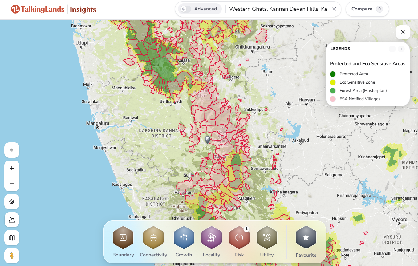
Visualizing Risk: How protected areas and eco-sensitive overlays appear on the TalkingLands Insights map interface, helping buyers identify overlapping constraints.
Crucial Implications for Real Estate Developers and Land Owners
If you currently own land, or are actively considering purchasing a large property anywhere in the traditional Western Ghats belt—such as the highly sought-after tourist regions of Coorg, Chikmagalur, or Sakleshpur in Karnataka; Wayanad or Idukki in Kerala; Sindhudurg in Maharashtra; or Ooty and Kodaikanal in Tamil Nadu—the ESA status is the single most important legal and environmental check you must perform, entirely superseding even basic title deed verification. Here is exactly how this framework impacts real estate economics:
- Severely Capped Commercial Development: Land situated inside the proposed ESA boundary has a rigid, immovable ceiling placed on its maximum development potential. While it is perfectly legal and fine to purchase the land for building a private farm, a small boutique homestay, or carrying out agricultural activities, it absolutely cannot be legally utilized for a massive commercial resort, an extensive plotted layout, or a high-density apartment project due to the strict 20,000 sq m built-up area and 50-hectare township bans.
- Massive Valuation Discrepancies: Because major corporate developers, hospitality chains, and mining conglomerates cannot touch ESA land for mega-projects, its open-market value is inherently and significantly lower than similar, equally scenic land situated safely outside the ESA boundary. Individual buyers must be extremely wary of "cheap" hill land heavily pushed by brokers; it is often priced suspiciously low precisely because it sits inside the restricted zone and is functionally useless for major commercial exploitation.
- The Shifting Boundary Risk: Because the notification is still a draft and under active review by the Sanjay Kumar committee until at least July 2027, the geographical line is literally movable. A plot that appears to be safely "outside" the ESA in a previous 2022 or 2024 draft might suddenly find itself dragged "inside" in the upcoming final notification due to a state survey revision, instantly eroding its commercial value and freezing any ongoing development plans.
- Layered, Stacking Compliance Risks: The ESA is almost never the only regulation at play in these hills. A single plot in the Ghats might simultaneously fall under the purview of strict state forest conservation laws, Coastal Regulation Zone (CRZ) rules if located near the sea, local master plan agricultural green belt zoning, and the central ESA rules. A clearance obtained in one department does not legally negate the severe restrictions of another, making due diligence extraordinarily complex.
How to Legally Verify if a Plot is Inside the ESA Boundary
Verifying a specific plot's ESA status requires extreme diligence and a multi-step approach. Buyers must absolutely not rely on verbal assurances from local brokers, eager sellers, or local panchayat officials who casually claim the land is "100% clear for development." You must perform two specific, distinct checks:
- The Official Gazette Verification (The Ultimate Authority): The ultimate legal authority is the MoEFCC draft ESA notification (the latest being the comprehensive seventh draft). This massive document contains an exhaustive, state-wise, district-wise, and taluk-wise list of all the thousands of villages currently included in the ESA. A buyer must obtain the precise Survey Number and official Revenue Village Name from the property title documents. If the village is listed in the gazette annexure, the land is broadly within the proposed ESA. The buyer must then physically consult the local Forest Department or Tehsildar with survey maps to understand the exact topographical boundaries within that specific village.
- The Fast Spatial Filter (Using Technology): Before diving into hundreds of pages of complex legal gazettes and archaic revenue maps, smart buyers and institutional investors use modern geospatial tools to perform a quick, highly accurate visual risk assessment. On the TalkingLands Insights platform, users can simply enter a property's location, open the Risk category panel, and activate the Protected Area layer. The map engine instantly shades known protected forests, wildlife corridors, and proposed eco-sensitive buffer zones. If the tool visually flags the plot as being inside or suspiciously close to a shaded ecological zone, it serves as a mandatory, flashing red signal to halt the deal and hire a specialized property lawyer to physically verify the survey numbers against the latest MoEFCC notifications before any financial transaction takes place.
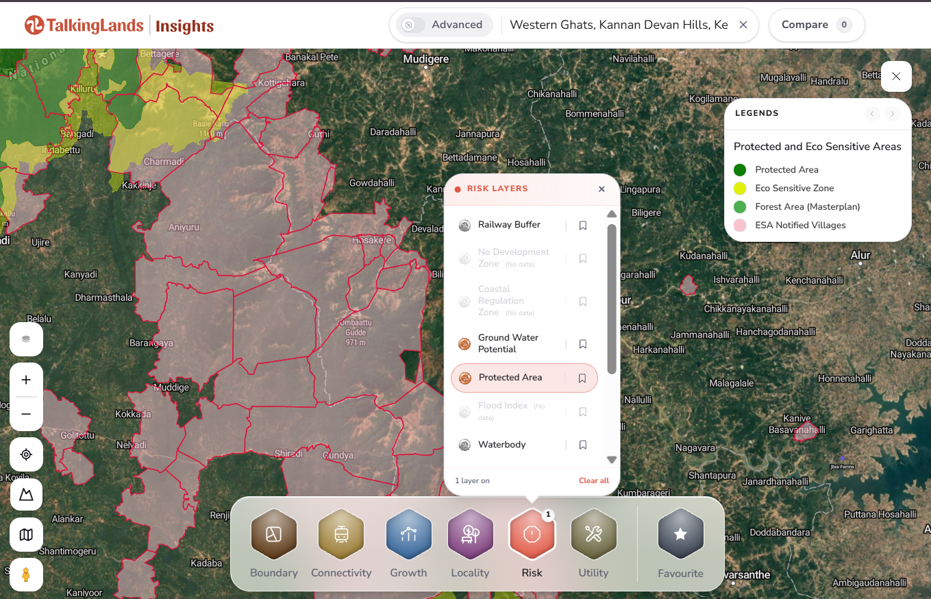
Step-by-step on TalkingLands Insights: Navigate to Risk → Activate the Protected Area layer to visually assess ecological constraints on any plot before committing funds.
Is Your Plot Inside a Protected Zone?
Don't risk millions of rupees on legally restricted land. Instantly check protected areas, eco-sensitive layers, and hidden zoning regulations for any plot using TalkingLands Insights before you negotiate. Sign up free today and claim your 5,000 welcome coins.
Sign Up Free — Get 5,000 Coins →Frequently Asked Questions
The Kasturirangan report (2013) recommended declaring about 37% of the Western Ghats - roughly 59,940 sq km of natural landscape - as an Eco-Sensitive Area with a strict no-development approach for large commercial projects. It deliberately excluded human settlements, farmland, and plantations to expertly balance ecological conservation with local livelihoods. It covers six peninsular states.
The Gadgil report (2011) was ecologically stringent, proposing to treat almost the entire Western Ghats (approx. 64%) as sensitive across three distinct regulatory zones. The Kasturirangan report (2013) significantly narrowed the protection footprint to about 37% (the contiguous natural landscape only) and completely excluded inhabited and agricultural areas, making it far less restrictive and more politically viable.
The proposed ESA spans six states and encompasses thousands of villages. According to the original framework proposals, the breakdown is approximately: Maharashtra (2,159 villages), Karnataka (1,576 villages), Tamil Nadu (135 villages), Kerala (123 villages), Goa (99 villages), and Gujarat (64 villages). Karnataka holds the largest geographical share at 20,668 sq km.
No. As of 2026, it remains a heavily contested draft. The Union Government has re-issued the seventh draft notification proposing 56,825.7 sq km as an ESA. An expert committee led by Sanjay Kumar has been granted a tenure extension until July 2027 to continue examining the objections of the stakeholder states. Until finalized, landowners remain in a state of prolonged legal uncertainty.
Under the Kasturirangan framework, all forms of new mining, quarrying, and sand mining are completely banned, with existing mines phased out over five years. Additionally, the establishment of new thermal power plants, highly polluting 'red-category' industries, and large building or township projects exceeding 20,000 sq m in built-up area or 50 hectares in size are strictly prohibited.
No. This is a very common myth spread by misinformation. The Kasturirangan framework explicitly protects existing homes, settlements, and agricultural lands. You can legally continue to live in your home, structurally repair it, and farm your land. The regulations are specifically designed to stop *new*, massive commercial and industrial exploitation, not to evict local residents.
Disclaimer: This article is intended for comprehensive informational purposes as of 2026 and does not constitute formal legal advice. The Western Ghats Eco-Sensitive Area (ESA) remains a draft notification, and its physical boundaries, village lists, and regulatory frameworks are subject to continuous change and ongoing legal dispute. Always independently verify the current MoEFCC notification, check applicable state and local zoning rules, and consult a qualified real estate advocate before purchasing land in or near the Western Ghats.

.png)

.png)


