.png)
For the past seven years, investing in the northern corridors of Bangalore required a massive, often uncomfortable leap of faith. Developers stood in front of raw patches of dirt in Devanahalli waving glossy 3D renders, and local brokers swore on their reputations that the "Airport Metro" would eventually rescue buyers from the grueling, two-hour commuter nightmare down the Outer Ring Road (ORR).
This week, that speculative narrative shifted into an undeniable physical reality.
The Bangalore Metro Rail Corporation Limited (BMRCL) officially took delivery of its first sophisticated, driverless prototype train for the Phase 2B blue line metro bangalore, rolling the six-coach formation directly into the Baiyappanahalli depot. With static, structural, and oscillation trial tests beginning on the depot tracks shortly, the countdown to operational deployment has formally begun.
This is not just an administrative milestone for urban planners; it is a violent infrastructure catalyst that will permanently rewrite the capital allocation maps of the city.
In a hyper-growth real estate market like Bangalore, infrastructure value follows a very specific three-wave pattern. The final and most explosive wave occurs when the infrastructure ceases to be a theoretical project and becomes a physical presence on the tracks. Capital that was sitting on the sidelines is suddenly deployed, and properties sitting inside the premium transit catchment zones undergo rapid upward valuation adjustments.
But you cannot play this infrastructure cycle blindly. The bengaluru airport metro is a massive 58-kilometer dual-phase corridor cutting through vastly different micro-markets—ranging from hyper-dense commercial tech zones to raw, un-converted agricultural frontiers. If you don't know how to read the spatial coordinates of this line, you risk buying into overpriced land that has already peaked, or worse, stepping into a catastrophic government land-acquisition buffer. Here is the data-backed, institutional-grade breakdown of the timelines, the routes, and the exact localities positioned for the highest capital appreciation as the airport corridor opens.
The first mistake novice investors make is treating the 58km Blue Line as a single, uniform project. The line is split into two massive, distinct structural undertakings governed by separate funding packages and civil engineering challenges. Smart money aligns its acquisition strategies with the BMRCL’s phased operational launch windows.
This elevated stretch runs right through the heart of Bangalore’s highest-density IT corridor. It features 13 strategic stations, including HSR Layout, Bellandur, Marathahalli, and Mahadevapura. Because this line cuts through heavily built-up commercial real estate, civil engineering delays around utility shifting and flyover modifications have been a persistent hurdle. The structural integration of this line is targeted to clear for full operational testing by early 2027.
This is the golden arc that is receiving intense administrative focus from the state government. It runs from KR Puram, sweeps past Hebbal, flashes through Yelahanka, and extends straight up to the Kempegowda International Airport terminal.
Because large stretches of Phase 2B run alongside the open flanking margins of the National Highway (NH-44), civil execution has been significantly faster than the inner-city routes. The high-priority KIA Terminal-to-Hebbal stretch is targeted to open its doors to early commuter runs between June and December 2026. This creates an immediate, highly lucrative value window for northern layouts over the next few months.
If you want to achieve maximum capital alpha along the namma metro airport line route, you must focus your portfolio on the intermodal megahubs. A standard metro station drives standard residential appreciation within a 1km radius. A multi-modal hub—where two or more independent mass-transit networks physically intersect—triggers an exponential compounding effect on surrounding land values.
To maximize metro connectivity property appreciation, you need to ignore broad zonal marketing and focus entirely on micro-market parcel data. Let's look at the exact corridors positioned for structural growth as the driverless trains begin static track tests.
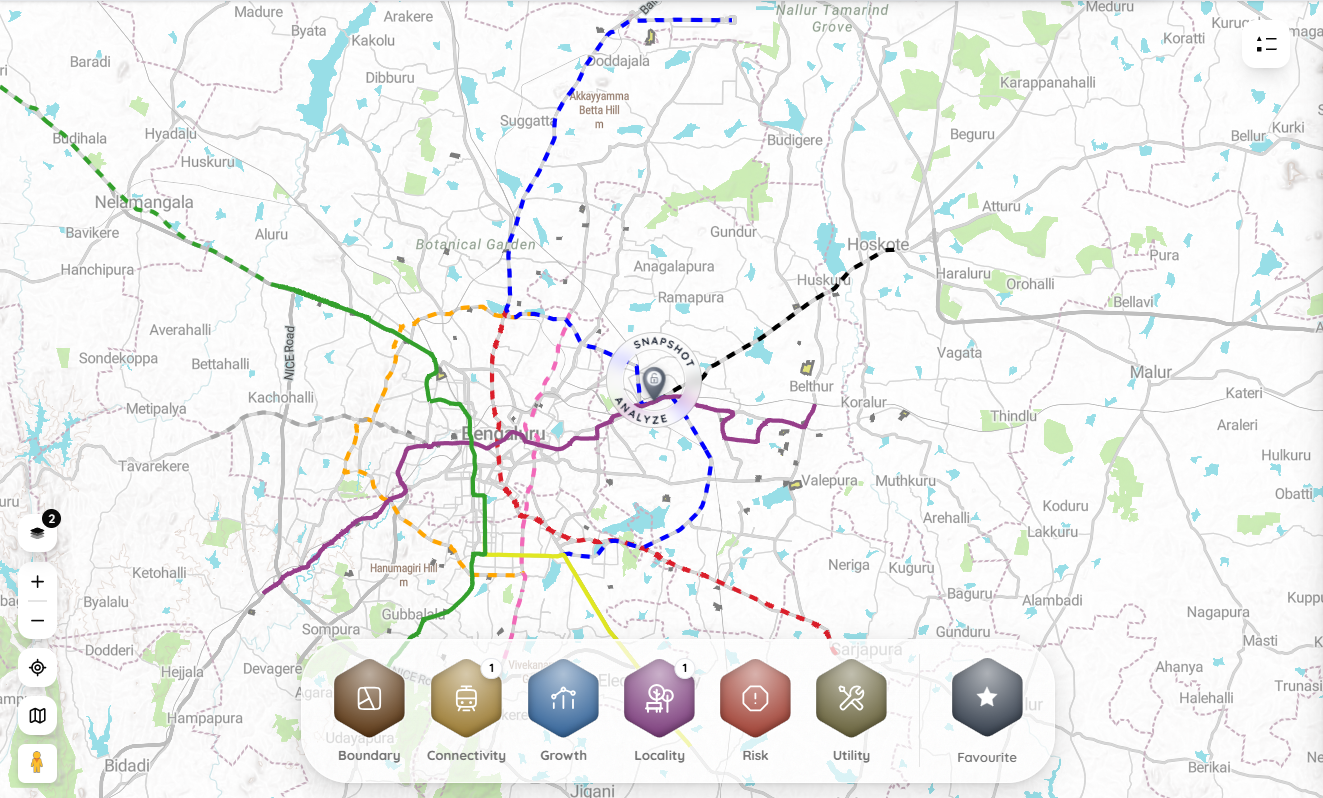
To help you underwrite your investments and understand how proximity to upcoming Blue Line stations alters your asset value, we have embedded our light-themed spatial valuation tool below. Input your property metrics to evaluate the projected growth windows.
Here is the dark side of infrastructure investing that real estate developers and slick brokers will never discuss during a site visit. Proximity to a metro station increases property values, but standing directly on the border of the transit line makes you a prime target for government demolition.
The construction of a massive elevated mass-transit system requires significantly more land than just the width of the concrete tracks.
The BMRCL operates under strict Right-of-Way (RoW) mandates. To accommodate massive multi-level stations, passenger entry/exit staircases, integrated bus bays, electrical sub-stations, and localized road widening to handle traffic dispersal, the state routinely issues late-stage land acquisition notifications.
If you buy a high-priced commercial plot or independent house sitting directly on the main highway frontage of the Blue Line route based purely on a broker's verbal assurance, you run a severe risk of buying a property that has already been earmarked for acquisition by the KIADB (Karnataka Industrial Areas Development Board).
How this data protects your capital:
Look at the TalkingLands Insights spatial report above. If an agent tells you that a specific commercial plot is safe from the upcoming station extensions, they are gambling with your net worth. But the moment you drop that asset’s exact Survey Number into our enterprise platform and activate the Connectivity and Metro layers, the hard geographic data is exposed. You can visually confirm if the plot's physical boundary clears the BMRCL acquisition buffers while remaining inside the high-growth 1.5km proximity radius. This 30-second digital screening ensures you buy into structural appreciation, not an imminent demolition notice.
The arrival of the first driverless prototype train at the Baiyappanahalli depot is the ultimate signal that the Blue Line has entered its final pre-operational phase. The transit economy is about to permanently alter the valuation structures of Hebbal, Yelahanka, the ORR tech belt, and the Devanahalli plotted frontier. The wealth transfer along this 58km corridor will be immense over the next 36 months.
But high-stakes infrastructure investing requires cold, uncompromising data.
Do not let fear-of-missing-out (FOMO) or aggressive sales pitches drive your multi-crore real estate decisions. Never hand over an advance booking cheque based on physical ground reality or unverified documents. Demand the exact survey number, pull the digital spatial reports, confirm the property safely clears the BMRCL construction setbacks, and align your capital strictly with verified data boundaries.

1. What is the route of the Bangalore Blue Line Metro?
The Blue Line (Phase 2A and 2B) spans roughly 58 km, connecting Central Silk Board to the Kempegowda International Airport (KIA). It runs entirely along the eastern Outer Ring Road (ORR) via key transit nodes like Marathahalli, KR Puram, Hennur, and Hebbal, before pushing straight north through Yelahanka toward Devanahalli.
2. When will the Bangalore Airport Metro line open?
The project is being executed in phases. The northern stretch connecting Hebbal directly to the KIA Terminal is highly prioritized, with operational trial runs targeted between June and December 2026. The full connectivity network extending down to Central Silk Board is expected to integrate by 2027.
3. Which localities will experience the highest property appreciation due to the Blue Line?
Properties located within a 1.5 km radius of major intermodal stations—specifically Hebbal, KR Puram, Marathahalli, and the fast-growing plotted developments in Yelahanka and Devanahalli—are positioned for the sharpest upward capital valuation adjustments.
4. What are the risks of buying real estate directly adjacent to the metro line?
The primary risk is government land acquisition under eminent domain. The BMRCL routinely acquires land adjacent to station points to construct staircases, electrical transformers, and terminal parking lots. Properties caught inside these construction buffers face partial or total demolition, with compensation fixed at government guidance rates.
5. How can I safely verify a property's proximity to the Blue Line?
You cannot verify transit metrics safely through physical site visits. You must secure the exact survey number of the plot and use an advanced digital spatial tool like TalkingLands Insights to overlay the property's layout polygon directly against the officially notified BMRCL alignments and station nodes.

.png)
.png)
.png)
