.png)
THE BIDADI ACQUISITION TRAP
A buyer we spoke to this year paid a hefty premium for a "future AI-city plot" on the Bengaluru–Mysuru corridor. The broker's pitch was irresistible: "Buy now before the Bidadi township is built." Three weeks later, when a bank valuer pulled the records, the survey number turned up inside the Bidadi township land acquisition notification. The government's claim sat firmly on the title. No DC conversion, no plan sanction, no clean resale — the money was locked in land the buyer could not build on.
This is the single biggest risk in the Bidadi belt right now, and almost nobody selling you a plot will mention it. The Greater Bengaluru Integrated Township (GBIT) — the ₹18,133-crore mega project everyone is talking about — is real, but so is the massive acquisition zone underneath it.
This guide explains exactly which villages and survey numbers are notified, what the compensation looks like, and how to verify any plot before you commit a single rupee.
Quick Answer: The Bidadi Township (GBIT) is proposed across roughly 9,600 acres spanning about 25 villages near Bidadi, but only around 518 acres across three villages — Kempayyanapalya, Mandalahalli and Vaderahalli — were finally notified for acquisition in Phase 1 (June 2026). A plot inside any acquisition notification cannot be freely developed, converted or resold. Before buying anywhere in the belt, always verify the exact survey number against the notified villages, the Byramangala lake buffer, and current zoning — which you can do at the parcel level on TalkingLands Insights.
What Is the Bidadi Township (GBIT) Land Acquisition?
The Greater Bengaluru Integrated Township (GBIT), popularly called the Bidadi Township, is a proposed "work-live-play" second central business district about 40 km from Bengaluru, in Bengaluru South district (formerly Ramanagara). The Karnataka government describes it as India's first AI-powered township, executed by the newly formed Greater Bengaluru Development Authority (GBDA) under the BMRDA.
The idea is not new. It was first notified back in 2006, and roughly 1,000 acres were acquired via KIADB in later years before the project stalled for nearly two decades. It was revived in 2025–26 with fresh branding, a new authority, and a financing plan worth ₹18,133 crore — funded largely through borrowings, including a reported HUDCO loan of around ₹9,011 crore. Of the total footprint, about 1,800 acres are earmarked for residential layouts and 5,681 acres for bulk development.
What Acquisition Means for Buyers: "Land acquisition" is the legal process by which the government takes private land — here, mostly fertile farmland — for the project, in exchange for compensation. Once your survey number falls inside a preliminary or final acquisition notification, your rights over that land are frozen until the process concludes. That is why the acquisition map, not the marketing brochure, is the document that actually matters. (For the investor and land-value angle, see our detailed Bidadi Smart City & GBIT Project Update).
Bidadi Township at a Glance: Phase-1 Notified Villages (2026)
Here is the current, reported status of the first phase of acquisition. Treat every figure as "reported — verify against the official notification and revenue records for your exact survey number."
(Note: Reported minimum compensation for Phase-1 land has been fixed at roughly ₹2.07–2.14 crore per acre, while many farmers are demanding ₹5–6 crore per acre. Figures are reported and subject to change by government order and court ruling).
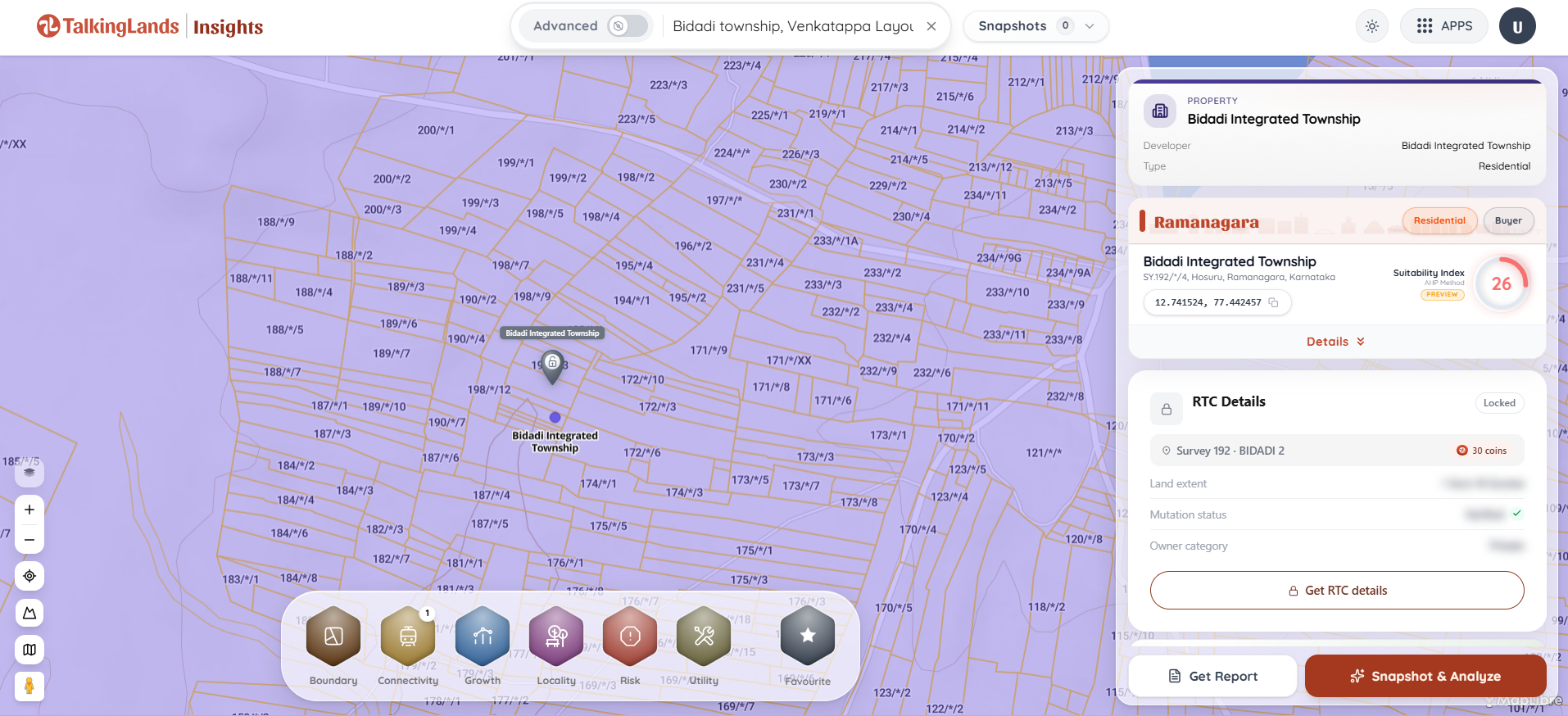
How to Check If a Plot Is Inside the Bidadi Township Acquisition Zone
Do not rely on the seller's word or a printed brochure. Follow these steps for any survey number in the Bidadi–Byramangala–Harohalli belt:
- Get the exact survey number in writing: Ask the seller for the village name and survey (and sub-division) number, plus the RTC/Pahani. A pitch that avoids giving you a precise survey number is itself a red flag.
- Check it against the notified villages: Confirm whether the village appears in the GBIT preliminary or final acquisition notifications. If the parcel sits in Kempayyanapalya, Mandalahalli or Vaderahalli, treat it as inside the zone until proven otherwise.
- Overlay the Byramangala lake and Rajakaluve buffers: The township's showpiece is the rejuvenation of the ~1,000-acre Byramangala Lake, which means strict enforcement of lake and stormwater-drain buffers. A plot inside a buffer is frozen regardless of acquisition status. (Learn more in our guide on how to find the risks associated with land).
- Confirm current zoning: The BMRDA master plan for this belt is being redrawn around the township. Verify whether the plot is residential, agricultural, or a new green-belt/buffer designation. (See our comparison of the best websites to check zoning regulations in India).
- Compare guidance value vs. asking price: Near the zone, the official guidance value runs far below broker asking prices. A large, unexplained gap is often the "AI-city" hype priced in before anything is built.
- Verify title and Khata independently: Check ownership, encumbrances, and Khata type with an independent lawyer, and confirm the e-Khata status. RERA registration of a layout is not an acquisition or zoning clearance.
Who and Which Areas Are Affected
The GBIT footprint touches nine revenue villages and several non-revenue villages around Bidadi hobli. The reported acquisition and protest activity is concentrated in and around Kempayyanapalya, Mandalahalli, Vaderahalli, Byramangala and Kanchugaranahalli. More than 10,000 farmers are described as affected, many of them small and marginal landholders, and farmer organisations have been protesting for over 400 days while preparing to challenge the acquisition in court over the consent requirement.
Beyond the immediate acquisition core, the wider belt — Bidadi town along the expressway, the Harohalli–STRR side, and the Ramanagara fringe — is where plotted layouts are actively riding the township pitch. These are exactly the pockets where "just outside the zone" claims need independent verification.
Common Mistakes Buyers Make in the Bidadi Belt
- Trusting "just outside the township" claims: Without the survey number plotted against the notified villages, this phrase is meaningless.
- Ignoring future phases: Phase 1 is only ~518 of ~9,600 acres. A parcel that is "outside" today can be pulled in by a later notification.
- Buying inside a lake or Rajakaluve buffer: A "future lake-view plot" near Byramangala can turn into permanently frozen capital.
- Treating RERA registration as clearance: RERA does not certify that land is outside an acquisition zone or a protected buffer — those are entirely separate checks.
- Paying township prices on farm land: The premium being charged often assumes a project that has spent two decades as paper and has built nothing on the ground yet.
How TalkingLands Insights Helps You Verify a Bidadi Plot
You cannot confirm acquisition boundaries, buffers, or zoning by driving out to Bidadi and looking at the dirt. TalkingLands Insights lets you enter a village and survey number and see the parcel on a live map with the layers that matter for this belt: boundary and cadastral outline, growth and zoning context, and risk layers such as lake and drain buffers.
On the exact same screen, you can pull Ownership Intelligence (RTC/Pahani holdings, owner category, and a civil court-case check) and e-Khata details, and request official record extracts — allowing you to move from a broker's promise to a documented view of what the land legally is.


Frequently Asked Questions
1. Is it safe to buy land near the Bidadi township in 2026?
It can be, but only after verification. Land inside the GBIT acquisition notification or inside the Byramangala lake buffer is effectively frozen. Verified plots that sit outside every notification and buffer, with clean zoning and title, can safely capture the corridor's growth. Always check the exact survey number before buying.
2. Which villages are notified for the Bidadi township land acquisition?
As reported for Phase 1 (June 2026), roughly 518 acres were finally notified across three villages — Kempayyanapalya (~384 acres), Mandalahalli (~71 acres) and Vaderahalli (~63 acres). The wider ~9,600-acre plan spans about 25 villages, but those remaining areas are at the preliminary or proposed stage. Verify the current status for any specific parcel.
3. Can I build on land that is inside the acquisition zone?
No. Once a survey number is inside a preliminary or final acquisition notification, you cannot freely obtain DC conversion, plan sanction, or a clean resale — the government's acquisition claim takes priority until the process concludes.
4. What compensation are Bidadi farmers being offered?
The reported minimum compensation for Phase-1 land is around ₹2.07–2.14 crore per acre. Many farmers are demanding ₹5–6 crore per acre, and the matter is contested, with farmer organisations preparing to challenge the acquisition in court. Compensation figures are reported and subject to change.
5. Will more Bidadi villages be added to the acquisition later?
The project envisions roughly 9,600 acres, far beyond the current Phase-1 notification. Later phases could bring additional villages and survey numbers into the acquisition zone, so a parcel that is "outside" today is not guaranteed to stay outside.
6. How do I check if my survey number is in the Bidadi township zone?
Enter the village and survey number into a spatial-intelligence platform like TalkingLands Insights to see the parcel boundary, acquisition and zoning context, and lake/drain buffers, plus ownership and e-Khata records — all on one screen. Confirm the official position with revenue authorities and an independent lawyer before buying.
7. Does the Bidadi township increase surrounding land value?
The corridor's connectivity — the Bengaluru–Mysuru Expressway, the STRR, and the existing Bidadi industrial base — is real and supports long-term value on verified land. But much of the current premium reflects township hype on a project that has not yet been built, so pay for the corridor, not the brochure.
.png)

.png)


