.png)
Best Websites to Check Zoning Regulations of a Property in India (2026)
If you are trying to find the best website to check zoning regulations for a specific plot of land, you have likely run into the same frustrating wall: you just want to know if your survey number is residential, commercial, or agricultural, but all you can find are massive, unreadable 200MB PDF master plans.
Knowing the legally permitted land use is the most critical step in property due diligence. If you buy an agricultural plot assuming you can build a villa, or a residential plot hoping to open a retail warehouse, you risk total capital loss and building plan rejection.
While the digitization of land records in India has improved dramatically, mapping municipal master plans to exact property boundaries remains highly fragmented. Whether you are a developer conducting site selection or an individual buyer doing initial research, here is a definitive comparison of the top websites and portals to check land zoning online in 2026.
Quick Answer: The best websites to check property zoning depend on your specific needs. TalkingLands Insights is the best all-in-one portal, overlaying official Master Plan zoning directly onto exact survey numbers. Official Planning Authority Portals (like BDA or DTCP websites) are the authoritative sources for official gazetted PDF maps. State GIS Portals (like Dishaank) are excellent for verifying cadastral boundaries but usually lack zoning data. Bhuvan (ISRO) provides unmatched satellite and topographical context but does not show municipal legal zoning.
What "Checking Zoning Online" Actually Requires
Before comparing the portals, it is important to understand why checking zoning is historically difficult. To accurately check a property's zoning, a website must successfully combine three different things:
- The Spatial Boundary: It must show the exact outline of your specific Survey Number on a map.
- The Color-Coded Land Use: It must overlay the municipal Comprehensive Development Plan (CDP) or master plan over that boundary to show if it falls in a yellow (residential), blue (commercial), or green (agricultural) zone.
- The Current Notified Plan: It must reflect the latest legally active master plan, not an outdated or purely proposed draft.
Most government websites provide either the boundary (revenue maps) or the zoning (PDF master plans), but rarely both in a searchable format.
The Top Websites for Zoning Regulations in India
Here is an honest breakdown of the platforms available to property buyers and developers today, including their strengths and limitations.
1. TalkingLands Insights (The All-in-One Spatial Portal)
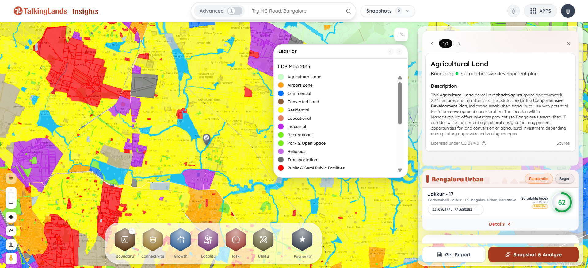
If you want to bypass reading complex PDFs and instantly know the zoning of a specific plot, TalkingLands Insights is the most powerful commercial tool available. It bridges the gap between official revenue boundaries and municipal planning data.
- How it works: You type in your specific village and survey number. The platform draws the exact boundary of the plot on a live satellite map and instantly overlays the official Master Plan zoning layer.
- The Pros: It is a single-screen solution. You don't just see the zoning color; you also see overlapping environmental risks (like lake buffers and Rajakaluve zones) and live ownership data simultaneously.
- The Cons: While it provides the fastest parcel-level precision, TalkingLands' deepest and most granular zoning coverage is currently concentrated in Karnataka (Bengaluru, Mysore, etc.), with rapid expansion ongoing in other states.
2. Official Planning Authority Portals (BDA, HMDA, State DTCPs)
Every city and state has an official urban planning authority (e.g., the Bangalore Development Authority, Hyderabad Metropolitan Development Authority, or the state Directorate of Town and Country Planning). These official websites are the primary legal source for all zoning data.
- How it works: You navigate to the authority's official website, locate the "Master Plan" or "Revised Master Plan (RMP)" section, and download the gazetted maps for your specific zone or ward.
- The Pros: These portals are the absolute, legally authoritative source. If there is a legal dispute, the maps downloaded from here are the final word.
- The Cons: The user experience is highly cumbersome. Data is usually trapped in massive, static PDF files. You cannot search by your survey number; you must visually guess where your plot is by referencing nearby roads and landmarks on the static image.
3. State GIS & Land Record Portals (Dishaank, Bhoomi, UP Bhulekh)
State governments have built robust online portals for digitized land records. In Karnataka, apps like Dishaank map survey numbers to physical GPS locations, while portals like Bhoomi handle the RTC (Record of Rights, Tenancy and Crops).
- How it works: You use the portal or mobile app to view the cadastral (boundary) map of a village or to pull the official ownership documents.
- The Pros: These are the best tools for verifying the exact shape, size, and government-recognized location of a survey number.
- The Cons: They are revenue tools, not urban planning tools. They will tell you who owns the land and if it is agricultural on paper, but they rarely overlay municipal master plan zoning. You will know the plot boundary, but you won't know if the city has zoned it for a future commercial corridor.
4. Bhuvan (ISRO) / National GIS
Operated by the National Remote Sensing Centre (NRSC) and ISRO, Bhuvan is India's national geo-platform.
- How it works: Users can access high-resolution satellite imagery and various thematic maps across the country.
- The Pros: It offers incredible topographical context, including Land Use and Land Cover (LULC) data, terrain mapping, and watershed data. It is excellent for macro-level geographic research.
- The Cons: Bhuvan tracks physical land cover (what is actually on the ground, like forests or built-up areas), not municipal zoning regulations (what you are legally allowed to build). It cannot tell you if your plot falls inside a commercial zone under a local city master plan.
.png)
At a Glance: Zoning Website Comparison
How to Check Zoning Using TalkingLands in 3 Steps
For a complete guide, read our in-depth post on How to Find the Zoning of a Property in India. If you want immediate answers, here is the fastest digital method:
- Locate the Property: Log into TalkingLands Insights and enter your specific village name and Survey Number. The platform will automatically draw the exact cadastral boundary of the plot on the map.
- Activate the CDP Layer: Turn on the Zoning / Master Plan layer. The map will instantly color-code the land underneath your plot (e.g., Yellow for Residential, Blue for Commercial, Green for Agricultural).
- Verify Constraints: With one click, you can simultaneously turn on the Risk layers to ensure the plot isn't sitting inside a restricted buffer zone, and check the live ownership data to confirm the seller's authority.

Frequently Asked Questions
1. What is the best free website to check zoning regulations in India?
For official, authoritative gazette maps, the best free websites are the official portals of the local planning authority (such as the BDA in Bangalore or HMDA in Hyderabad). However, these are often static PDF maps. For interactive, parcel-level zoning checks, spatial intelligence platforms like TalkingLands offer free signup with 5,000 free coins to overlay zoning directly onto a survey number.
2. How can I check land zoning online by survey number?
You cannot usually search by survey number on static government PDF master plans. To do this, you must use a GIS platform like TalkingLands Insights. By entering your village and survey number into the search bar, the platform maps the boundary and automatically superimposes the city's legal land-use zoning layer over your specific plot.
3. Is there a single official zoning map website for all of India?
No. Land and urban planning are state subjects in India. Every city and planning authority maintains its own separate master plans and zoning regulations. There is no single government website that centralizes municipal zoning for the entire country, which is why commercial aggregators are necessary for cross-border research.
4. Can Google Maps show me property zoning?
No. Google Maps displays physical terrain, roads, satellite imagery, and commercial points of interest. It does not contain municipal legal data, Comprehensive Development Plan (CDP) boundaries, or official zoning regulations.
.png)

.png)


