
The Bangalore CDP 2031 is the city’s long-term plan for growth and transport. It sets rules for land use, road development, Metro lines, and public spaces. The goal is simple. Make the city easier to move around. Support growth. Improve daily life for residents.
The CDP Plan Bangalore 2031 also links development to transport. So, homes, jobs, roads, and Metro stations are planned together. This helps reduce traffic stress. It also guides how the Bangalore cdp 2031 zone areas develop in the future.
This article explains the plan in a clear language. No jargon. Just what you need to know.
What’s All in This Page
The Bangalore Comprehensive Development Plan 2031 is a long-term urban planning blueprint prepared by the Bangalore Development Authority to guide the city’s growth and infrastructure development up to 2031. It outlines land use zoning (residential, commercial, industrial, and green spaces), transportation networks, housing, and public amenities to ensure planned and sustainable expansion of Bengaluru. The plan also focuses on reducing congestion, improving connectivity, and balancing urban development with environmental conservation.
It covers:
The idea is to prevent unplanned growth. So, the Bangalore infrastructure plan 2031 acts like a city roadmap.
A key focus is mobility. Traffic is a big stress in the city. The plan tries to spread development outward. This reduces pressure on the center. It also supports balanced growth across the Bangalore cdp 2031 zone regions.
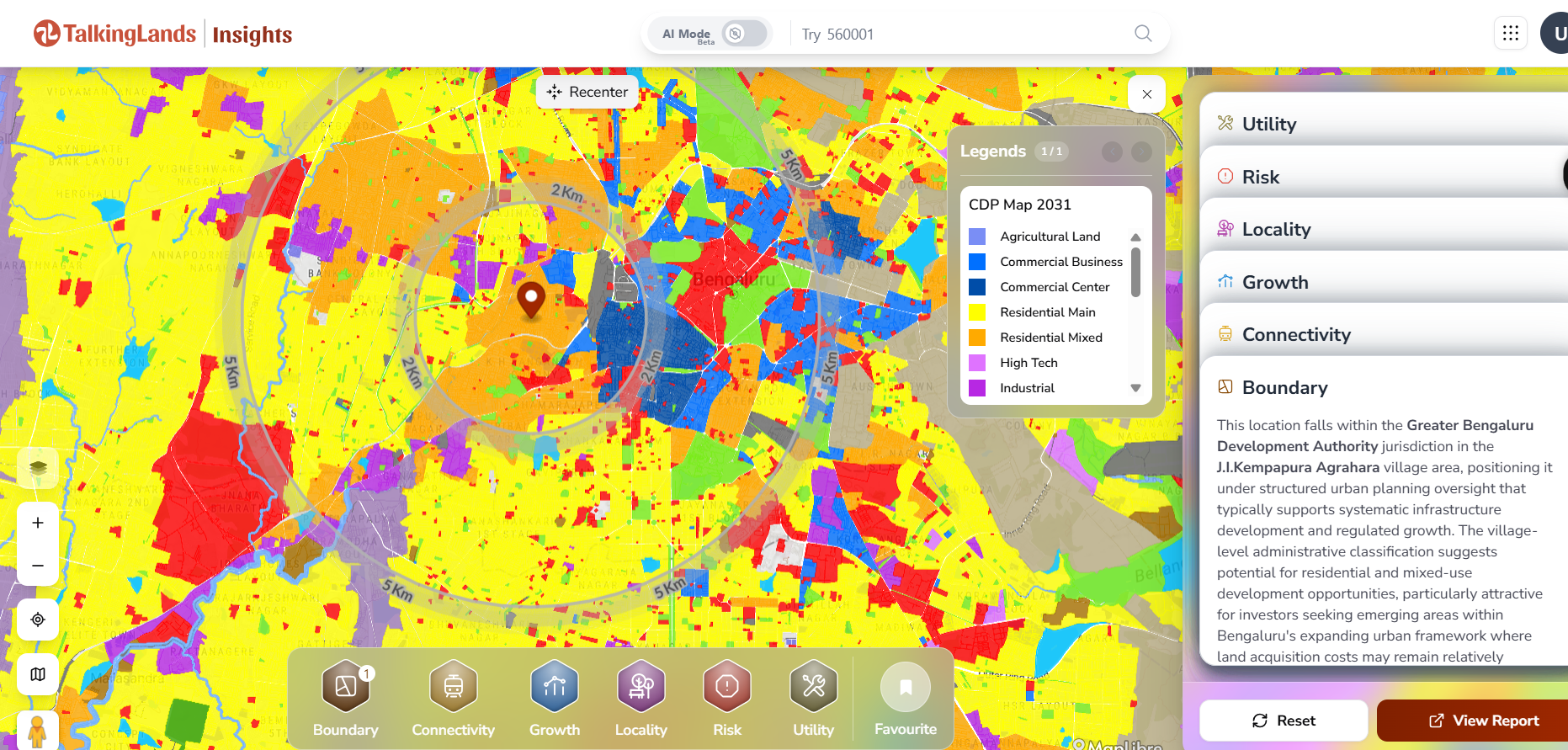
Get the CDP Plan of 2031 by registering at insights.talkinglands.com
Bangalore’s older statutory plan is RMP 2015. It focused on building a basic “ring + radial” road structure and pushing public transport like commuter rail and bus priority lanes.
The newer RMP/CDP 2031 draft expanded that idea. It talked about more ring roads, more radial roads, and more Metro coverage, including Metro routes planned along the PRR.
One important note for accuracy: recent reporting says the RMP-2031 was scrapped, and BDA has moved to preparing RMP-2041. So treat 2031 as the “draft direction” the city was planning around, not a final, enforced document.
City plans change how land and infrastructure evolve over time. You can explore spatial layers and location context for Bangalore on TalkingLands to better understand how planning directions translate on the ground.
Road development is one of the biggest parts of the plan.
A 116 km Peripheral Ring Road is proposed. It circles the city outside the current Outer Ring Road.
This helps:
It also connects highways and industrial zones.
The city will increase arterial corridors:
From 13 → 26 major radial roads
These roads connect outer areas to the city core.
About 13 elevated road corridors are planned.
These aim to:
Some future routes may carry both:
This saves land and reduces disruption.
The overall goal is simple. Spread traffic out. Avoid bottlenecks. Reduce daily commute stress.
Road proposals affect access, traffic flow, and development patterns. TalkingLands helps you view major corridors and surrounding areas through layered maps and location data.
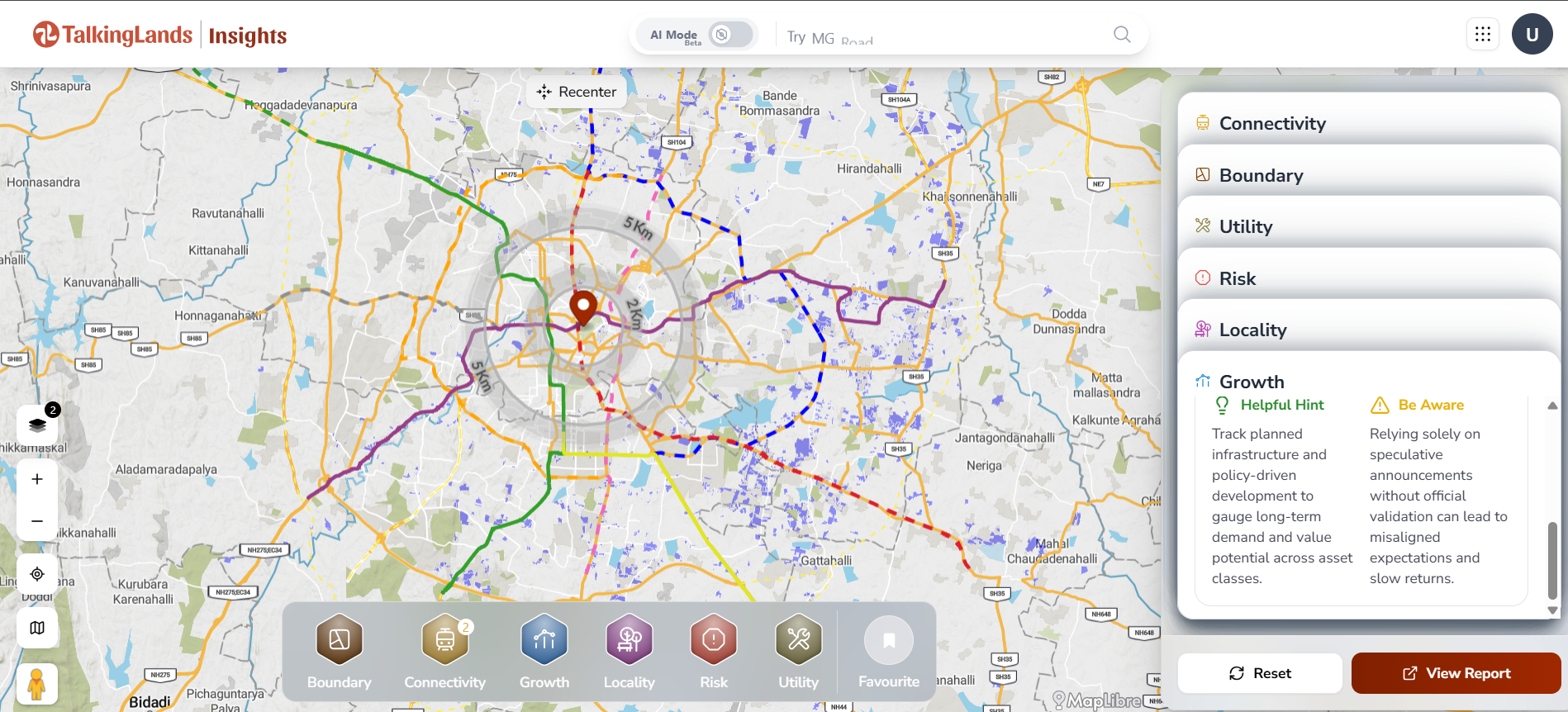
Get Combined Metro + Road corridors in the Bangalore via insights.talkinglands.com
TalkingLands makes it easier to understand zoning, infrastructure corridors, and planning layers related to the Bangalore CDP 2031. Instead of manually reading large planning documents, you can check location-level insights in a structured way.
Go to the TalkingLands insights portal.
Sign up on the platform to create your account.
Once registered, you receive 5000 free tokens to explore planning layers, zoning details, and infrastructure insights.
Creating an account allows you to:
Enter the:
Or simply move and zoom the map to your desired area.
This helps you pinpoint the exact parcel in Bengaluru.
Enable the CDP / RMP planning layer to view:
This gives clarity on how the area was structured under the planning framework prepared by the Bangalore Development Authority.ured under the planning framework prepared by the Bangalore Development Authority.
The Bangalore CDP 2031 supports large Metro expansion. Metro is seen as the backbone of city mobility.
Key Metro additions include:
More areas will get Metro stations. This means fewer people need to use cars or bikes for long trips.
Metro also supports real estate growth along corridors. But the plan tries to balance this with zoning rules in the Bangalore cdp 2031 zone map.
Suburban rail connects outer towns and city edges. It supports people who travel long distances daily.
The plan integrates suburban rail with Metro and bus systems. So people can switch modes easily.
This helps:
It also reduces pressure on central Bangalore.
Buses remain the main mode for most people. The Bangalore infrastructure plan 2031 proposes:
Feeder buses help people reach Metro and suburban stations.
The plan also supports:
The goal is simple. Make switching from bus → Metro → suburban rail easy and predictable.
1. What is the Bangalore Comprehensive Development Plan 2031?
It is the Revised Master Plan that guides land use, infrastructure, and transport development in Bengaluru up to the year 2031.
2. Who prepares the CDP 2031?
The plan is prepared and implemented by the Bangalore Development Authority.
3. How does Metro expansion help the city?
Expansion of the Namma Metro connects more residential and job zones, reducing road traffic and improving commute time.
4. What is the Peripheral Ring Road (PRR)?
It is a proposed 116 km ring road around the city designed to reduce congestion within core urban areas.
5. How does CDP 2031 impact real estate growth?
Zoning regulations and transport corridors influence where residential and commercial development can expand.
6. What are the key zoning categories in the plan?
The plan divides land into residential, commercial, industrial, public/semi-public, and green zones for organized development.
7. How does the plan improve infrastructure?
It focuses on upgrading roads, drainage systems, water supply, and public utilities to support future population growth.
8. Does CDP 2031 address traffic congestion?
Yes, it includes projects like new ring roads, metro expansion, and road widening to ease traffic issues.
9. How does the plan support sustainable development?
It emphasizes protecting lakes, green belts, and open spaces while promoting eco-friendly urban growth.
10. Why is CDP 2031 important for residents and investors?
It provides a clear roadmap for future development, helping residents understand city growth and guiding investors on high-potential areas.

.png)
.png)
.png)
