Yellow Line Metro Bangalore (2026): Route, Stations & the Areas Set to Boom
Yellow Line Metro Bangalore (2026): Route, Stations & the Areas Set to Boom
It is a familiar story for property investors along the Hosur Road belt. Years ago, an investor paid a steep "metro premium" for a parcel advertised as being "just steps away from the upcoming Yellow Line station." Fast forward to today: the line is finally operational. However, when the investor attempts to develop or rent out the property, reality hits hard.
Their plot is physically close to the station as the crow flies, but it requires a hazardous, 2-kilometer walk across the pedestrian-hostile, multi-lane Hosur Road highway to actually reach the entrance. Worse, a neighbor who bought a plot just one street over realizes their land sits entirely inside an unbuildable agricultural Green Belt. The metro is running, but their capital is completely stuck.
A live metro does not guarantee automatic, limitless upside. In Bengaluru, location, true walkability, and statutory zoning still dictate the final value of your investment.
With the Yellow Line Metro finally unlocking the massive Electronic City IT corridor, property values are soaring. Here is your complete 2026 guide to the operational Yellow Line, the 16 stations, the micro-markets set to boom, and exactly how to digitally verify a plot’s true connectivity before you pay the metro premium.
Quick Answer: The Namma Metro Yellow Line runs 19.15 km from RV Road to Bommasandra, featuring 16 stations. It officially opened on August 10, 2025, finally connecting the Electronic City IT corridor to the city’s core network. It features a live interchange at RV Road (Green Line), and future mega-interchanges at Central Silk Board (Blue Line) and Jayadeva Hospital (Pink Line). Note: While it opened with limited train frequency, BMRCL's fleet has expanded to 8+ driverless trains as of 2026, significantly improving intervals down to 15 minutes or better. Always verify a plot's true walking distance to a station and its Master Plan zoning before paying a premium.
What is the Yellow Line? (The Electronic City Connector)
For over two decades, the south-eastern IT belt of Bengaluru—specifically Electronic City and Bommasandra—has been an economic powerhouse severely bottlenecked by the infamous Hosur Road and Central Silk Board traffic gridlocks.
The Yellow Line was designed to break this bottleneck. Originating at RV Road in Jayanagar, the fully elevated line travels through the dense residential hubs of BTM Layout and Bommanahalli, navigates the massive Silk Board junction, and runs directly down Hosur Road to serve Electronic City Phases 1 and 2, Hebbagodi, and Bommasandra.
For hundreds of thousands of IT professionals, this line transforms a grueling two-hour commute into a predictable, 35-minute end-to-end ride.
The Complete 16-Station List
Understanding exact station placement is critical for property investors. Here is the official alignment from North-West to South-East.
Yellow Line Metro — All 16 Stations
Station Name
Area / Suburb
Interchange / Notes
1. RV Road
Jayanagar / Basavanagudi
Interchange: Green Line (Live)
2. Ragigudda
JP Nagar 2nd Phase
Dense residential access.
3. Jayadeva Hospital
Bannerghatta Road Junction
Interchange: Future Pink Line
4. BTM Layout
BTM 2nd Stage
Major student & residential hub.
5. Central Silk Board
Silk Board Junction
Interchange: Future Blue Line
6. Bommanahalli
Hosur Road
Access to HSR Layout sectors.
7. Hongasandra
Hosur Road
Mixed-use fringe access.
8. Kudlu Gate
Hosur Road
Connects to Harlur & Haralur Road.
9. Singasandra
Hosur Road
Growing mid-segment residential.
10. Hosa Road
Hosur Road
Critical access to Sarjapur Road interiors.
11. Beratena Agrahara
Hosur Road
Pre-Electronic City industrial zone.
12. Electronic City
E-City Phase 1/2
The primary IT/BT employment hub.
13. Konappana Agrahara
Electronic City Phase 1
Infosys Foundation Station.
14. Huskur Road
E-City Fringes
Emerging residential layouts.
15. Hebbagodi
Hosur Road
Biocon Station; industrial anchor.
16. Bommasandra
Hosur Road Fringes
Southern terminus; manufacturing hub.
Interchanges: The True Network Effect
Transit real estate explodes in value where lines cross. The Yellow Line features three of the most critical interchange nodes in the entire Namma Metro network:
RV Road (Live): Connects the Yellow Line to the Green Line, allowing commuters from Electronic City to travel directly to Majestic, Yeshwanthpur, or Peenya without entering surface traffic.
Central Silk Board (Future Blue Line): Long known as India's most congested junction, this node is transforming into a massive transit hub. Once the Blue Line opens, professionals in Electronic City will have a single-ticket ride directly to Bellandur, Marathahalli, and the Kempegowda International Airport.
Jayadeva Hospital (Future Pink Line): This mega-interchange connects the Yellow Line with the upcoming Pink Line, tying the deep southern Bannerghatta Road suburbs to the eastern IT belt.
Areas Set to Boom (The Investment Zones)
With the line now active, these micro-markets are absorbing the highest capital flows:
Electronic City (Phase 1 & 2): The undeniable anchor. While historically viewed strictly as a commercial and rental market, high-quality residential demand is spiking now that families can easily commute to central Bengaluru schools and hospitals.
Bommasandra & Hebbagodi: The southern terminus areas are transitioning from pure manufacturing/industrial zones to affordable and mid-segment residential hubs.
Bommanahalli, HSR Layout fringes, & BTM: These mature suburbs are seeing a massive revitalization. Older properties are being aggressively acquired and redeveloped into premium apartments and co-living spaces.
The Hosur Road → Attibele/Anekal Fringe: Long-term investors are already moving further south down Hosur Road past the Bommasandra terminus, banking on the inevitable future expansion of the corridor toward the Tamil Nadu border.
The "Metro Premium" Trap (Common Mistakes)
Do not blindly pay a 30% markup because a broker claims a property is "Metro Adjacent." Navigate these realities:
The Walking-Distance Illusion: Hosur Road is a massive, high-speed national highway. A plot might physically sit 400 meters from a station, but if there is no skywalk or safe crossing, the actual walkable route for a commuter could be heavily compromised. True transit-oriented development requires seamless pedestrian access.
The Frequency Reality (2026): When the line opened in August 2025, it operated with a skeletal fleet of just three CBTC driverless trains, resulting in frustrating 25-minute wait times. However, this is rapidly changing. With Titagarh Rail Systems delivering the 8th trainset by early 2026 and more arriving continuously, train intervals have dropped to ~15 minutes and are progressively stabilizing toward normal metro frequencies. While it's a massive improvement, buyers should track current operations before assuming peak 3-minute transit times.
Unbuildable CDP Zoning: You find a relatively cheap plot 800 meters from the Kudlu Gate station. It looks like a steal. But when you check the Comprehensive Development Plan (CDP), the land is zoned as an agricultural Green Belt or sits in a lake buffer. You cannot legally build on it, rendering the metro connectivity useless.
Speculating on Far Fringes: Buying deep into Anekal or Attibele expecting immediate metro benefits is risky. While growth will eventually spill over, it will take years for those deep fringes to mirror Electronic City's valuations.
How to Verify a Plot Before Paying the Premium
If you are buying anywhere near the Yellow Line, execute these three non-negotiable checks:
Map the True Distance: Digitally overlay the property's cadastral boundary to verify the actual, walkable route to the finalized station entrances.
Check the CDP Zoning: Ensure the land is officially zoned for residential or commercial use. Read our guide on how to find the zoning of a property to understand the process.
Verify Ownership: Pull the RTC and Encumbrance Certificate to ensure the seller holds a clear, unfragmented title.
Buying Near the Electronic City Corridor?
From commercial plots in Bommasandra to residential investments in HSR and BTM, share your exact requirements. Our team helps you find and verify legally cleared properties on active transit nodes.
TalkingLands provides spatial verification and connects you with verified partners — we do not sell plots directly.
Verify the "Metro Effect" Instantly with TalkingLands Insights
You cannot confirm true station walkability or CDP zoning by trusting a builder's brochure.
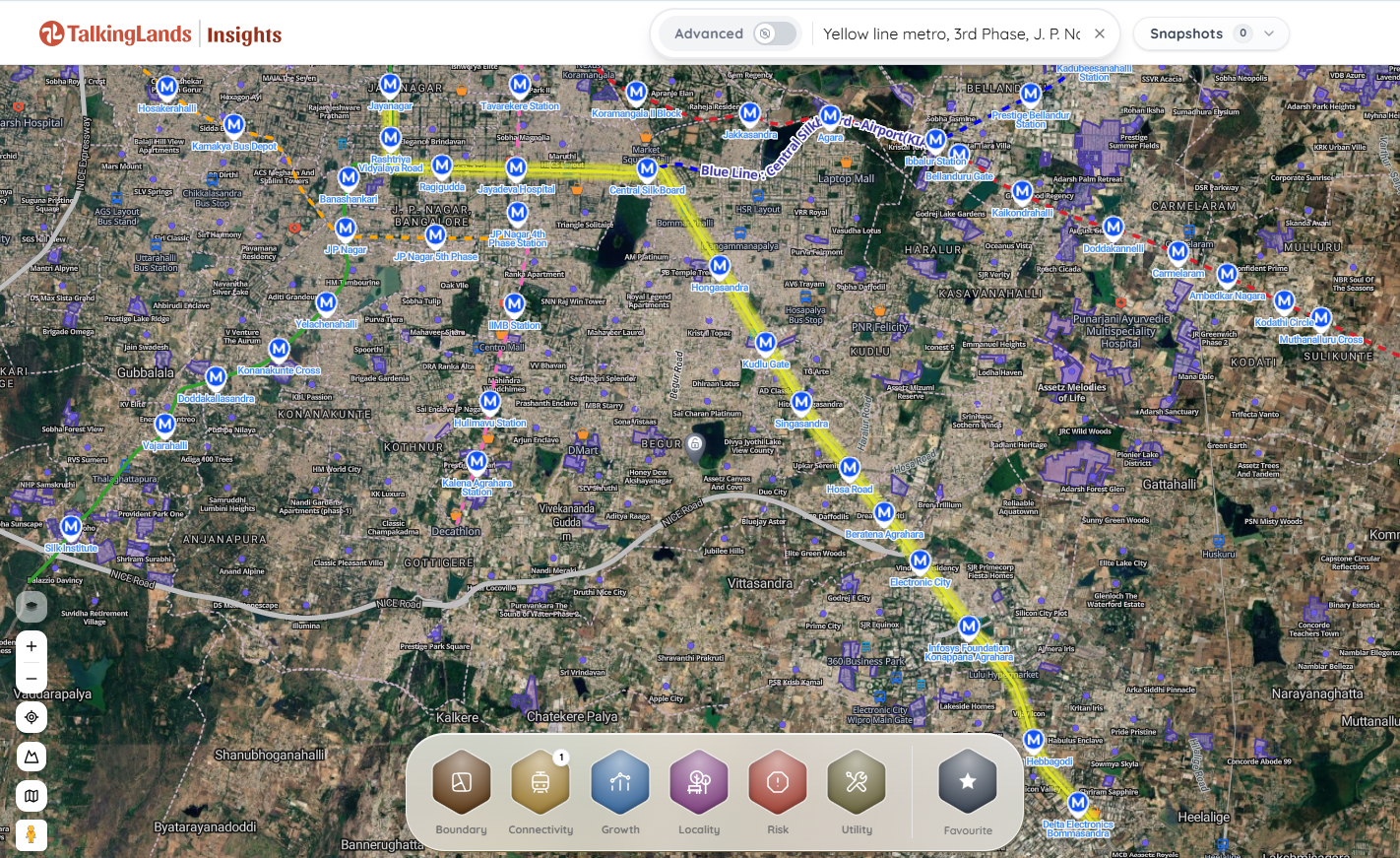
With TalkingLands Insights, checking your plot takes seconds.Drop your survey number into the platform to visualize the property on a live satellite map. Activate the Connectivity Layer to see the precise distance and routing path to the active Yellow Line stations. Toggle the Zoning / Land-Use Layer to instantly verify if the plot is legally buildable under the BDA Master Plan, ensuring you don't overpay for restricted green belt land.
The Metro is Live. Is Your Plot Safe?
Before you pay a metro premium, check a plot's real walking distance to the station and its official CDP zoning. Drop a survey number to see the truth. Sign up free and get 5,000 free coins to map your plot instantly.
1. Is the Yellow Line Metro operational in Bangalore?
Yes. The Yellow Line officially opened to the public on August 10, 2025. While the line initially launched with a skeletal fleet of trains resulting in longer wait times, BMRCL's fleet has expanded to 8+ driverless trains as of 2026, significantly improving service frequencies.
2. What is the route and how many stations does the Yellow Line have?
The Yellow Line covers a distance of 19.15 kilometers and features 16 elevated stations. The route starts at RV Road in Jayanagar, travels through BTM Layout and Central Silk Board, and runs down Hosur Road to terminate at Bommasandra.
3. Does the Yellow Line reach Electronic City?
Yes. The line was specifically built to connect the IT hub to the city. It features stations servicing Electronic City Phase 1 and 2, including Konappana Agrahara and Huskur Road.
4. Which areas benefit most from the Yellow Line?
The primary beneficiaries are the micro-markets along the Hosur Road corridor. This includes BTM Layout, Bommanahalli, HSR Layout (fringes), Kudlu Gate, Electronic City, Hebbagodi, and Bommasandra.
5. What are the major interchanges on the Yellow Line?
The Yellow Line currently interchanges with the operational Green Line at RV Road. In the near future, it will also connect to the Blue Line (Airport Line) at Central Silk Board and the Pink Line at Jayadeva Hospital.
6. How can I check if a property is actually near a Yellow Line station?
You can use spatial intelligence platforms like TalkingLands Insights. By entering your property's survey number, the system overlays the plot's boundary onto a live map, allowing you to accurately measure the true walking route from the plot to the station entrance while simultaneously checking the land's official CDP zoning.
.png)
.png)



%20(1).png)
.png)