Bengaluru Pink Line Metro (2026): Route, Stations & the Areas Set to Boom
Bengaluru Pink Line Metro (2026): Route, Stations & the Areas Set to Boom
It is the classic Bengaluru real estate trap. An investor finds a prime plot on Bannerghatta Road advertised as "just a 5-minute walk from the upcoming Pink Line Metro." They pay a steep 30% "metro premium" over the standard market rate, expecting massive rental yields. A year later, the alignment is finalized, and they discover the actual station entrance is 3 kilometers away, hidden behind an uncrossable highway junction. Even worse, the plot they bought sits inside a protected green belt where commercial development is banned. The premium they paid has completely evaporated.
In a city choked by traffic, Namma Metro connectivity is the ultimate catalyst for property appreciation. The Pink Line Metro (Line 5) is currently Bengaluru’s most highly anticipated infrastructure project, promising to finally connect the deep southern residential suburbs directly to the northern tech corridors.
As the line gears up for its phased opening in 2026, developers and property sellers have aggressively priced in the "metro effect." Before you pay that premium, you need to understand exactly where the stations are, when the trains will actually run, and how to verify if a plot genuinely benefits from the corridor.
Quick Answer: The Namma Metro Pink Line (Line 5) spans 21.25 km from Kalena Agrahara in the south to Nagawara in the north, featuring 18 stations. It is predominantly an underground line (12 underground, 6 elevated). The elevated section (Bannerghatta Road to Tavarekere) is currently targeted to open around ~August 2026, while the complex underground section is slated for ~December 2026 (subject to BMRCL/CMRS approvals). Always verify a property's true walking distance to a station and its local zoning regulations before paying a metro premium.
What is the Pink Line (Line 5)?
The Pink Line represents a massive engineering achievement for the Bangalore Metro Rail Corporation Limited (BMRCL). Stretching 21.25 kilometers, it slices vertically through some of the city's oldest, most densely populated, and traffic-heavy neighborhoods.
The Route: The line originates in the deep south at Kalena Agrahara (on Bannerghatta Road), moves north through JP Nagar and Dairy Circle, tunnels directly under the central business district (MG Road and Shivajinagar), and terminates at Nagawara on the Outer Ring Road (ORR).
Elevated vs. Underground: To navigate the congested city core, the Pink Line is mostly tunnelled. It consists of 6 elevated stations along the southern Bannerghatta Road stretch, and 12 underground stations from Dairy Circle onwards. As of mid-2026, the tunneling work is complete, and the focus is heavily on station finishing, signaling, and track systems.
The Complete 18-Station List
Understanding the exact station placement is critical for property investors. Here is the official alignment from South to North.
Pink Line Metro — All 18 Stations
Station Name
Type
Interchange / Notes
1. Kalena Agrahara
Elevated
Southern terminus (Bannerghatta Road).
2. Hulimavu
Elevated
Serves residential hubs off Bannerghatta Rd.
3. IIMB
Elevated
Near Indian Institute of Management Bangalore.
4. JP Nagar 4th Phase
Elevated
Core residential access.
5. Jayadeva Hospital
Elevated
Interchange — Yellow Line.
6. Tavarekere
Elevated
Northern end of the elevated Phase 1.
7. Dairy Circle
Underground
Start of the underground section.
8. Lakkasandra
Underground
Serves inner south Bengaluru.
9. Langford Town
Underground
Premium residential access.
10. National Military School
Underground
Central Bengaluru access.
11. MG Road
Underground
Interchange — Purple Line.
12. Shivaji Nagar
Underground
High-density commercial/transit hub.
13. Cantonment
Underground
Connects to Cantonment Railway Station.
14. Pottery Town
Underground
Serves Frazer Town / eastern suburbs.
15. Tannery Road
Underground
North Bengaluru access.
16. Venkateshpura
Underground
Residential access near ORR.
17. Kadugundanahalli
Underground
Serves dense northern neighborhoods.
18. Nagawara
Underground
Interchange — Blue Line (Airport Line). Northern terminus.
The Interchanges: Why This Line is a Game-Changer
A standalone metro line offers linear benefits, but interchanges create exponential value. The Pink Line features three massive interchange nodes that fundamentally alter Bengaluru's real estate dynamics:
Jayadeva Hospital (Interchange with Yellow Line): This turns BTM Layout and the Bannerghatta Road junction into a transit mega-hub, allowing commuters to effortlessly switch lines to reach Electronic City and Bommasandra.
MG Road (Interchange with Purple Line): This connects the deep south directly to the East-West spine. Residents in Hulimavu can now commute to Whitefield or Kengeri entirely via metro.
Nagawara (Interchange with Blue Line): By late 2026/2027, the Blue Line will connect directly to the Kempegowda International Airport. Nagawara will act as the master junction for travelers moving from the city core to the airport.
The Opening Timeline (Phased Launch)
It is crucial for buyers to understand that the entire 21.25 km line will not open simultaneously. BMRCL is targeting a phased approach:
Phase 1 (Elevated Section): The 6 stations from Kalena Agrahara to Tavarekere. Following RDSO safety trials, this section is tentatively targeted for an ~August 2026 launch (pending final Commissioner of Metro Railway Safety - CMRS - inspections).
Phase 2 (Underground Section): The highly complex 12-station stretch from Dairy Circle to Nagawara is currently targeted for ~December 2026.
(Note: Mega-infrastructure timelines are notoriously fluid. While the elevated section is in its final testing phases, buyers should always treat these dates as targets rather than guarantees).
Areas Set to Benefit (The Investment Zones)
If you are looking to invest, these micro-markets along the corridor are poised for the highest appreciation and rental demand:
Bannerghatta Road (Kalena Agrahara, Gottigere, Hulimavu): Historically bottlenecked by terrible traffic, these southern suburbs will finally have rapid access to the city core. Perfect for long-term residential buyers and apartment investors. (Note: If buying further south towards the Bannerghatta National Park, strictly verify the plot against the Bannerghatta ESZ buffer zone rules to ensure it isn't legally unbuildable).
JP Nagar & BTM Layout: As the Jayadeva interchange comes online, these mature neighborhoods will see massive commercial and retail revitalization, alongside high demand for rental housing from tech workers.
Dairy Circle / Lakkasandra: With the start of the underground section, these inner-city pockets will experience a significant reduction in surface traffic, making them prime targets for boutique luxury apartments and commercial office spaces.
Nagawara & ORR: The northern terminus will become a commercial powerhouse. With the convergence of the Pink and Blue Lines, Nagawara will be highly favored by IT firms looking for seamless airport connectivity.
The "Metro Premium" Trap
The most expensive mistake you can make in 2026 is paying a premium for a "metro-adjacent" property without independent spatial verification.
The Walking Distance Illusion: A broker's brochure might claim a plot is "500 meters from the station." But if that 500 meters requires crossing a massive, pedestrian-hostile multi-lane highway or a complex interchange, the true walking distance is vastly longer. The property loses its commuter appeal.
Unbuildable Land: A plot located 200 meters from the Tavarekere station is worthless if the Comprehensive Development Plan (CDP) zones it as agricultural green-belt, or if it lacks an official DC Conversion.
Alignment Shifts: Buying purely speculative land before final gazette notifications means you could pay a premium for a station that gets moved 2 kilometers down the road during final engineering reviews.
Verify the "Metro Effect" with TalkingLands Insights
You cannot determine the true value of a transit-oriented property by looking at a builder's PDF brochure. You must map the exact geographical reality.
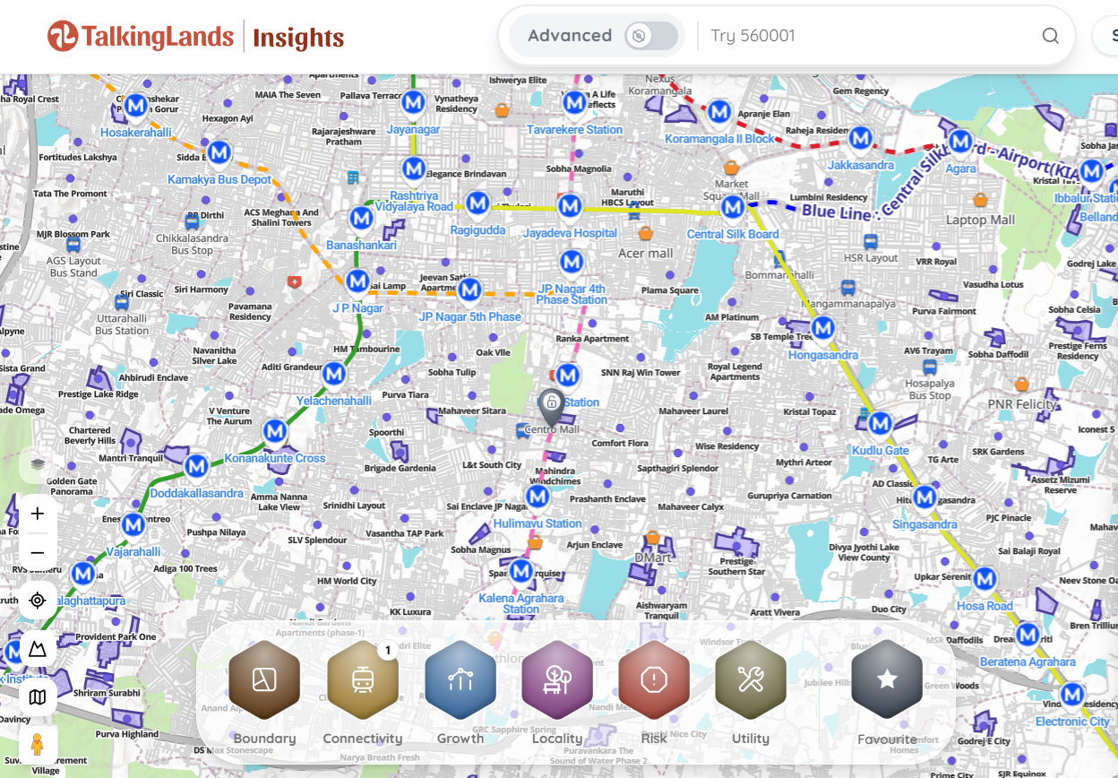
With TalkingLands Insights, you can drop your Survey Number onto the live map and activate the Connectivity Layer. The platform will draw the exact, real-world distance from your plot to the finalized Pink Line station entrances.
You can then activate the Zoning & Growth Layers to ensure the land is legally buildable under the master plan—verifying that you are paying for genuine commercial potential, not just hype.
Don't Overpay for the Metro Premium
Check if a plot is actually near a Pink Line station, verify its real growth drivers, and ensure it is legally buildable. Sign up free and get 5,000 free coins to map your plot's connectivity and zoning instantly.
From residential plots on Bannerghatta Road to commercial assets near Nagawara, share your investment requirements. Our team will help you find and verify legally cleared properties on actual growth corridors.
TalkingLands provides spatial verification and connects you with verified partners — we do not sell plots directly.
Frequently Asked Questions
1. What is the route of the Bangalore Pink Line Metro?
The Namma Metro Pink Line (Line 5) runs from Kalena Agrahara in south Bengaluru (along Bannerghatta Road) to Nagawara in the north (on the Outer Ring Road). It spans 21.25 kilometers, tunneling under central areas like MG Road and Shivajinagar.
2. How many stations does the Pink Line have?
The line features 18 stations in total. There are 6 elevated stations starting from Kalena Agrahara to Tavarekere, and 12 underground stations starting from Dairy Circle and terminating at Nagawara.
3. When will the Pink Line Metro open?
BMRCL is targeting a phased opening. The elevated section (Kalena Agrahara to Tavarekere) has cleared critical RDSO speed trials and is targeted for launch around August 2026. The more complex underground section (Dairy Circle to Nagawara) is targeted to open around December 2026. Both dates are subject to final CMRS safety approvals.
4. Which other metro lines does the Pink Line connect to?
The Pink Line offers three major interchanges: It connects to the Yellow Line at Jayadeva Hospital, the Purple Line at MG Road, and the upcoming Blue Line (Airport Line) at Nagawara.
5. Are property prices increasing near the Pink Line?
Yes. Real estate markets along Bannerghatta Road, JP Nagar, and Nagawara are seeing significant "metro premium" appreciation. However, buyers should ensure that the property is legally buildable (properly zoned) and truly within walking distance of the finalized station entrances before paying premium prices.
6. How do I check if my property is near a Pink Line station?
You can use spatial intelligence platforms like TalkingLands Insights. By entering your property's survey number, you can map the exact geographical distance and actual walking route from the plot boundary to the nearest finalized metro station.
.png)
.png)



%20(1).png)
.png)