.png)
BDA, BMRDA or Local Planning Authority? How to Check Who Approves Your Property (2026)
The "Approved Layout" Illusion
You find a beautifully developed plotted layout on the outer edge of electronic city or off Sarjapur Road. The gated community features wide tar roads, underground drainage, streetlights, and an ornate entrance arch. The broker confidently hands you a file containing a "Panchayat Approval" and a signed Khata document, explicitly stating that the project is completely legal and cleared for immediate villa construction. The price is highly competitive, and the location looks promising. You pay a substantial advance.
Three weeks later, you take the property file to your bank to secure a home construction loan. The legal cell of the bank reviews the documentation and completely rejects your file.
The bank's verdict? The layout is an unauthorized, illegal development. The Panchayat has no legal power to approve residential layouts, and the property sits in a zone controlled by a completely different Local Planning Authority. Suddenly, your lifelong savings are locked into a non-bailable "revenue site" with a permanent threat of municipal demolition.
When you buy a plot, an apartment, or an independent house in the expanding boundaries of Greater Bengaluru, knowing which planning authority approves my property is the most critical piece of legal due diligence you can perform.
Buyers routinely assume that any local government stamp constitutes a valid approval. However, in Bangalore’s highly complex and evolving administrative landscape, building an unapproved structure can get your property blacklisted, cut off from municipal water utilities, or entirely demolished.
Whether you are an investor buying a plot on the outskirts or a developer underwriting a new parcel, here is the definitive 2026 guide to understanding BDA limits, the role of the BMRDA, the new Greater Bengaluru Authority framework, and how to verify your property's real jurisdiction before spending a single rupee.
Quick Answer: A property's true legal approving authority is dictated purely by its geographic location relative to notified statutory limits. The core city and its master layouts are governed by the BDA and GBA. The surrounding metropolitan periphery is split among BMRDA's localized Planning Authorities (like Anekal, Hoskote, or Nelamangala PA). Gram Panchayats cannot legally approve residential layouts. To avoid layout traps, cross-reference your survey number against a digitised planning authority boundary map before buying.
Why the Approving Authority Decides Everything
The specific government body that holds statutory jurisdiction over your plot doesn't just dictate who signs your paperwork—it directly controls the structural value and legality of your real estate investment. If you buy a property approved by an entity that does not possess the legal right to grant approvals for that specific survey number, your property is legally classified as an unauthorized encroachment.
The approving authority directly determines:
- Building-Plan Sanctions: You cannot legally build a house without an approved building plan. A building plan must be sanctioned by the specific body holding the regulatory master plan for that coordinate.
- The Khata Classification: Securing a legitimate e-Khata or A-Khata depends entirely on whether your layout was approved by the correct planning body. If it was approved illegally by a Gram Panchayat, you will be permanently stuck with a "B-Khata" or a revenue receipt, making the property nearly un-resellable.
- Home Loan Eligibility: Scheduled commercial banks and RBI-registered NBFCs have strict legal filters. They will only fund properties that have clear technical clearances from the BDA, BMRDA, or respective Local Planning Authorities. They will not finance unauthorized revenue layouts.
- Infrastructure Utilities: Legitimate connections for municipal potable water lines (BWSSB) and power connections (BESCOM) require a valid occupancy certificate backed by a sanctioned plan from the correct authority.
- Demolition Risk: Under current structural frameworks, structures built without approvals from the rightful planning body are subject to structural audits, heavy penalties, and immediate demolition drives under local municipal laws.
Who Approves What in the Bangalore Region?
The administrative map of Bengaluru is divided into distinct administrative rings, shifting from the core city out to the rural peripheries. Furthermore, following sweeping administrative reforms, the old BBMP framework has evolved significantly into the new Greater Bengaluru Authority (GBA) system to handle the sheer scale of the metropolis.
Understanding who holds the master plan for your specific patch of land requires understanding the differences between these agencies:
.png)
How Jurisdiction is Formally Decided
A property's planning jurisdiction is not an opinion—it is an absolute statutory fact determined by the precise coordinates of its survey number. The state government explicitly details the exact boundary lines of every authority through official gazette notifications.
As Bengaluru has expanded horizontally, the lines have naturally shifted. For example, land that was considered completely rural under a local village Gram Panchayat ten years ago may now fall squarely under the jurisdiction of the Anekal Planning Authority or the Hoskote Local Planning Authority.
When a Local Planning Authority (LPA) is established or extended by the BMRDA, it absorbs all master-planning and layout-sanctioning powers for that region. From that date forward, any layout plan approved by a local village council within those limits is legally null and void. The plot must go through the formal BMRDA or LPA layout clearance channel.
The Great Khata Risk: Panchayat Layouts & Revenue Sites
The single largest trap facing retail property buyers on the outskirts of Bangalore is the Gram Panchayat Khata fraud.
Brokers frequently exploit the ambiguity of changing boundaries to sell cheap agricultural plots. They obtain a building or layout permission from a local village Panchayat, form a rudimentary layout on agricultural land without undergoing the mandatory DC Conversion process, and pass it off to unwary city buyers as a legal, approved project.
The Legal Reality of Panchayat Khatas
Under the Karnataka Town and Country Planning (KTCP) Act, a Gram Panchayat has absolutely zero authority to convert agricultural land into residential plots, nor can it sanction a multi-plot layout master plan.
If you buy a plot in a layout that only features a Panchayat layout approval, you are purchasing an unauthorized "revenue site."
Consequently, the municipal body (now under the expanding GBA framework) will refuse to issue you an A-Khata. Instead, your property will be locked out of formal registration loops, you will be ineligible for any standard commercial bank financing, and your asset will be exposed to systemic risk should the state execute a clearing or infrastructure widening drive.
How to Check Which Authority Governs Your Plot
To ensure your capital is protected, you must run a rigorous geographical check on your land parcel before executing any final sale agreements.
1. Cross-Reference the Local Master Plan & CDP
The BDA and the respective BMRDA Local Planning Authorities publish Comprehensive Development Plans (CDPs) and master plan limit maps. You must identify which specific planning authority includes your village and survey number inside its regulatory boundary lines. (To understand how master planning impacts property lines, read our deep dive into the CDP Plan Bangalore Guide).
2. Verify Layout Sanctity (BDA vs. DTCP Clearance)
If the plot sits within BDA limits, it must feature a formal BDA layout sanction number. If it sits on the peripheral rings controlled by the BMRDA, it must have an official layout approval from the local LPA or the Directorate of Town and Country Planning (DTCP). (Follow the exact steps in our checklist on how to check if a layout is BDA or DTCP approved).
3. Check the Status of DC Conversion
Every piece of land in Karnataka is natively classified as agricultural. Before any planning authority can legally sanction a residential or commercial layout, the land must undergo a formal DC Conversion process handled by the District Collector. A planning authority approval stamped on an un-converted agricultural survey number is a major legal red flag.
4. Leverage Spatial Intelligence Technology
Sifting through dense municipal text logs, tracking down physical gazette maps, or visiting localized planning offices to find out where your plot sits is an exhausting, multi-week task. The modern, seamless approach is to view the land through interactive spatial layers. By mapping the exact survey number, you can visualize the precise planning boundaries instantly.
Common Mistakes Property Buyers Make
- Trusting a "Panchayat Khata" as an Approval: Believing that because a local village secretary signed a property ledger, the layout is legally authorized for residential housing.
- Assuming BDA Rules Cover the Entire Outskirts: Assuming that any property with a "Bangalore" address falls under BDA limits. Large chunks of highly active real estate corridors are outside BDA limits and fall under localized LPAs.
- Ignoring Evolving Boundaries: Buying land based on a five-year-old title report without checking if a newly notified Local Planning Authority has modified the zoning or master plan for that survey number. (Learn how to accurately verify property records in our guide on how to verify your survey number before buying land in Bangalore).
Map Your Planning Jurisdiction Instantly
You do not have to guess which government office holds the keys to your property's building approvals, nor do you have to navigate complex municipal boundary text files manually.
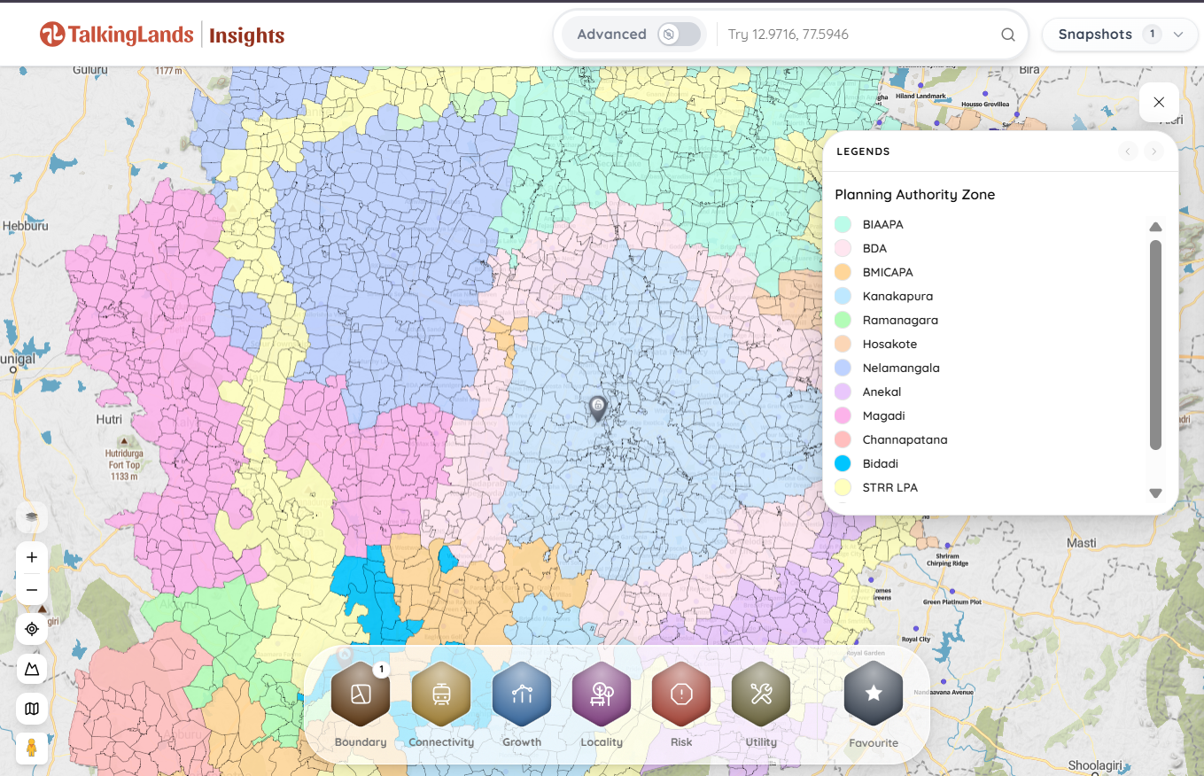
With TalkingLands Insights, verifying your property's rightful planning authority is seamless. By entering your plot's exact survey number into our advanced mapping workspace, you can overlay its real cadastral boundary directly onto a live satellite map.
Simply activate the Planning Authority Maps & Boundary layer to instantly reveal exactly which statutory body governs your coordinates—whether it's the BDA, a specific local LPA under the BMRDA, or an unmapped Panchayat pocket. Spot unauthorized layouts in seconds and protect your investment capital before paying an advance.
-p-2000.png)
Frequently Asked Questions
1. How do I check which planning authority approves my property?
The most reliable way is to determine the exact survey number and village of the property and cross-reference them with the officially notified jurisdiction maps of local urban bodies. Alternatively, you can drop your survey number directly into spatial intelligence platforms like TalkingLands to visually identify the active planning authority layer for your plot instantly.
2. What is the fundamental difference between BDA and BMRDA?
The BDA (Bangalore Development Authority) holds jurisdiction over the core Bangalore Metropolitan Area (BMA), acting as both a developer of mega-layouts and a master planning agency. The BMRDA (Bangalore Metropolitan Region Development Authority) is an umbrella body that coordinates planning across the wider metropolitan region outside the BDA limits, operating via distinct, localized Local Planning Authorities (LPAs).
3. Is a Gram Panchayat layout approval safe to buy?
No. Gram Panchayats are legally barred from sanctioning residential layouts or commercial master plans on multi-acre tracts of land. A Panchayat layout is generally considered an unauthorized development or a "revenue site," meaning it cannot secure a standard A-Khata, faces high home-loan rejection rates, and is exposed to statutory enforcement or demolition risks.
4. What is a Local Planning Authority (LPA)?
A Local Planning Authority is a localized urban planning body operating under the aegis of the BMRDA to govern specific peripheral growth corridors around Bangalore. Examples include the Anekal Planning Authority, Hoskote Planning Authority, Nelamangala Planning Authority, and Magadi Planning Authority. They hold exclusive layout sanctioning powers within their notified zones.
5. Does the new Greater Bengaluru Authority (GBA) replace the BBMP?
Yes. The administrative framework has evolved to replace the legacy BBMP system with the unified Greater Bengaluru Authority (GBA). While the GBA oversees municipal maintenance, property tax collection, and building-plan sanctions for individual houses on pre-authorized plots, the overarching layout master plans are still generated by the BDA or respective BMRDA planning bodies.
6. How can I confirm if a peripheral plot falls within BDA limits map borders?
You must verify the property coordinates against the officially gazetted boundaries of the Bangalore Metropolitan Area. Since these borders are irregular and frequently weave through individual village survey numbers, using a digital spatial intelligence platform is the most accurate way to trace the exact line separating BDA limits from peripheral BMRDA zones.
.png)

.png)


