%20(1).png)
Building Height Restrictions Near Bangalore Airport (2026 Guide)
The High-Rise Trap in North Bangalore
You have just finalized a massive land parcel in Devanahalli, sitting perfectly on the airport corridor. The local Comprehensive Development Plan (CDP) zones it for commercial use, and the road width grants you a generous Floor Area Ratio (FAR). You project a 15-story tech park or luxury apartment complex. The math looks incredible. You pay the advance, draw up the master plan, and apply for your building sanctions.
The application is rejected.
Why? Because your plot sits directly in the approach funnel of Kempegowda International Airport (KIA), and the Airports Authority of India (AAI) has capped your permissible building height at a mere 15 meters (roughly 4 to 5 floors).
When you buy or develop land anywhere near an airport, municipal zoning and FAR are only half the story. You are legally bound by the Ministry of Civil Aviation and the Airports Authority of India (AAI). A plot that looks primed for a skyscraper can be legally capped at a low height, rendering your paid-for FAR completely useless.
Whether you are a developer underwriting a 10-acre parcel or a homebuyer planning a multi-story independent house in North Bangalore, here is the definitive 2026 guide to airport height restrictions, the AAI NOC process, the Colour-Coded Zoning Map (CCZM), and how to verify your exact permissible height before you invest.
Quick Answer: Building heights near airports are strictly regulated by the AAI to ensure safe flight paths. Permissible height is dictated by your plot's distance and direction from the runway (the Aerodrome Reference Point). Before buying land, you must check the official Colour-Coded Zoning Map (CCZM) and apply for a No Objection Certificate (NOC) via the AAI's online NOCAS portal. To check instantly, map your survey number against a spatial intelligence airport zoning layer.
Why Airport Height Limits Matter
Ignoring aviation zoning is one of the most expensive underwriting mistakes a developer or investor can make. The impact of an unexpected height restriction cascades through your entire project:
- Trapped FAR (Floor Area Ratio): You pay a premium for land with high FAR (the total buildable area allowed). But if the AAI caps your physical height, you cannot build tall enough to consume that FAR. You paid for buildable space you are legally forbidden to use.
- Project Redesign & Delays: Discovering a height limit late in the process forces you to scrap architectural plans, redesign for wider/shorter footprints (which reduces open green space), and delays project launches by months.
- Resale & Valuation: Land near the airport is marketed as "high potential." However, if a retail buyer purchases a plot only to find they cannot build past two floors, the resale value is permanently stunted compared to unrestricted plots just a few kilometers away.
The Legal Framework: Aircraft Rules & AAI NOC
Airport zoning in India is not a mere guideline; it is federal law. It is governed by the Aircraft (Demolition of Obstructions caused by Buildings and Trees etc.) Rules, 2015.
Under these rules, the Airports Authority of India (AAI) is mandated to ensure that no structure, building, or even a crane used during construction penetrates the obstacle limitation surfaces (OLS) around an airport.
To manage this, the AAI uses two primary tools:
- NOCAS (No Objection Certificate Application System): The online portal where developers must submit their exact coordinates and proposed evaluations to get an official NOC for height clearance.
- CCZM (Colour-Coded Zoning Map): A published map for major airports that divides the surrounding region into color-coded grids. Each grid specifies a permissible height limit. If your proposed building falls comfortably below the CCZM limit, the local municipal authority can often grant approval without requiring you to go through the lengthy AAI NOC process.
How Permissible Height is Decided (AMSL vs AGL)
To understand airport zoning, you must understand the difference between Above Ground Level (AGL) and Above Mean Sea Level (AMSL).
The AAI regulates the top elevation of your building relative to sea level (AMSL), not just how tall the building is from the dirt (AGL). If your plot sits on a natural hill, your allowable building height (AGL) will be significantly shorter than a plot sitting in a valley, because both buildings must stay below the same invisible AMSL flight-path ceiling.
The invisible ceiling is shaped by specific zones:
- The Approach Funnel: The most restrictive zone, extending outward from the ends of the runway. Buildings here are severely restricted to ensure planes have a clear glide path for landing and takeoff.
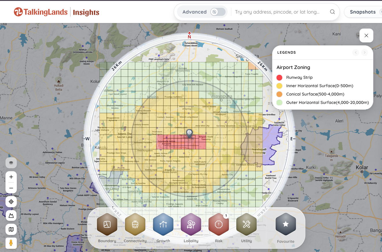
- Inner Horizontal Surface (IHS): A radius (usually a few kilometers) around the Aerodrome Reference Point (ARP) where heights are kept strictly uniform and low.
- Conical and Outer Horizontal Surfaces: As you move further away from the airport (up to 20 km), the invisible ceiling slopes upward, allowing for progressively taller high-rises.
Airport Zoning — Height & NOC at a Glance
.png)
The Bangalore/KIA Context (2026)
Kempegowda International Airport (KIA) in Devanahalli is the epicenter of Bangalore's massive northern expansion. With the operationalization of Terminal 2 and the second runway, the flight paths and approach funnels are wider and more active than ever.
If you are evaluating land in the booming North Bangalore micro-markets—including Devanahalli, Yelahanka, Hebbal, Bagalur, and the Bellary Road airport corridor—airport zoning is the ultimate determining factor for commercial viability.
Why do high-rise projects here hinge on AAI clearance? Because the land values in these corridors are priced based on high-density tech parks and luxury vertical living. If your specific plot falls into a restrictive pocket of the CCZM, the underlying math of the land valuation breaks entirely.
Furthermore, North Bangalore contains a secondary trap: the Yelahanka Air Force Station. Defense airports have their own distinct, and often far stricter, height and construction restrictions under the Ministry of Defence, which frequently overlap with civilian CCZM grids.
(Curious about how future infrastructure impacts land? Read our guide on the proposed Bangalore Second Airport in South Bengaluru).
How to Check Your Plot's Limit
You should never pay an advance on airport-corridor land without verifying the height limits. There are two ways to do this:
- The Manual / Official Route: You must hire a qualified surveyor to determine the exact Site Elevation (AMSL) of your plot using WGS-84 coordinates. You then cross-reference these coordinates with the officially published Kempegowda Airport CCZM grids. For definitive clearance, you must submit these surveyed coordinates into the AAI's online NOCAS portal and await an official response.
- The Spatial Intelligence Route: For rapid underwriting and pre-purchase due diligence, modern developers use spatial software. By dropping your exact survey number into a spatial platform, you can instantly overlay the Airport Zoning Map and CCZM layers to see the indicative permissible height limit without waiting weeks for a physical survey.
What to Verify Before Buying / Planning
Checking the airport height restriction is a critical step, but it must be done alongside overlapping compliance checks. Ensure you verify:
- The Local CDP / Zoning: A plot might be cleared by the AAI for 50 meters, but if the local zoning rules classify it as low-density residential, you still can't build a high-rise.
- Road Width vs. FAR: In Bangalore, your FAR is heavily dependent on the width of the approach road. A high FAR combined with a strict AAI height cap forces you to build "wide and short," which may violate local setback rules.
- Other Buffers: Ensure your plot isn't trapped by highway setbacks, high-tension power lines, or environmental buffer zones.
Common Mistakes Buyers & Developers Make
- Assuming FAR Governs Height: FAR dictates the volume you can build, not the altitude. Many buyers purchase high-FAR land, assuming they can build a 20-story tower, only to be legally capped at 5 stories by the AAI.
- Ignoring Topography (The AMSL Trap): If the airport runway sits at an elevation of 900m AMSL, and the AAI caps your zone at 950m AMSL, you have 50 meters of buildable space. But if your plot sits on a hill that is already at 930m AMSL, you can only build 20 meters tall. Topography eats into your height limits.
- Buying Without Checking the Funnel: Believing that "distance is safety." A plot 5 km away on the side of the runway might be cleared for a high-rise, while a plot 8 km away directly inside the approach funnel is severely restricted.
Map the Airport Risk Instantly
Reading complex CCZM grids and cross-referencing topographical AMSL elevations is incredibly tedious and prone to error if done manually on a spreadsheet.
This is exactly why TalkingLands Insights features dedicated spatial layers designed for instant due diligence. By entering your survey number into our platform, you can instantly overlay the cadastral boundary of your plot on a live satellite map. Activate the Airport Zoning & Constraints layer to immediately view the indicative permissible height for your exact location.
Instead of waiting weeks for a surveyor, you can disqualify restrictive parcels in seconds and focus your capital on land that actually supports your master plan.
%20(1)-p-2000.png)
Frequently Asked Questions
1. How can I check the building height restriction near the airport?
The official method is to determine your plot's coordinates and elevation (AMSL) and check them against the Colour-Coded Zoning Map (CCZM) published by the Airports Authority of India (AAI). For final clearance, you must apply through the AAI's online NOCAS portal. For instant pre-purchase checks, use spatial intelligence tools like TalkingLands to overlay the zoning map directly on your survey number.
2. What is an AAI height NOC?
A No Objection Certificate (NOC) for height clearance is a legal document issued by the Airports Authority of India. It certifies that your proposed building or structure does not penetrate the obstacle limitation surfaces (OLS) and poses no threat to aircraft navigation.
3. What is the Colour-Coded Zoning Map (CCZM)?
The CCZM is a standardized grid map provided by the AAI for major airports. It uses different colors to indicate specific elevation caps (AMSL) across the city. If your proposed building height falls below the limit shown in your specific grid color, local municipal bodies can often sanction the plan without requiring a separate, individual AAI NOC.
4. How far from the airport do height restrictions apply?
Under the Aircraft Rules 2015, height restrictions generally apply up to a 20-kilometer radius from the Aerodrome Reference Point (ARP). However, the severity of the restriction decreases significantly the further you move away, unless you are directly in the approach funnel.
5. Can I build a high-rise near KIA in Bangalore?
Yes, high-rises are permitted in many parts of North Bangalore near KIA, provided they sit outside the restrictive approach funnels and Inner Horizontal Surfaces, and comply with the specific AMSL limits dictated by the CCZM for that exact grid.
6. Do I need an AAI NOC to build a small independent house?
If your plot is located deep within the restrictive zones (like the approach funnel), you may need a NOC even for a 2-story house. However, for most small residential structures located a few kilometers away, the building height easily falls beneath the CCZM auto-approval limits, meaning the local municipal authority can sanction it without sending you to the AAI.
.png)

.png)


