.png)
How to Check Groundwater Before Buying Land in India (2026 Guide)
The "Dry Borewell" Trap
You find the perfect plot on the outskirts of the city. The road access is excellent, the title is clear, and the price fits your budget perfectly. You pay the advance, register the land, and bring in the drilling rig to sink your first borewell before construction begins. The rig drills past 500 feet, then 800 feet, and finally hits 1,200 feet. Dust flies out. No water.
You try a second spot. Dry again. Suddenly, your "perfect" plot requires a lifetime dependency on private water tankers.
When you buy land in rapidly expanding Indian cities, how to check groundwater before buying land is often the most overlooked piece of due diligence. Buyers assume that if they drill deep enough, water is guaranteed. In hard-rock terrains like Bangalore, Hyderabad, or Chennai, this is a financially devastating myth.
Without a reliable groundwater source, your property's liveability plummets, construction costs soar, and resale value stagnates. Here is the definitive 2026 guide to checking groundwater availability, understanding water-table depth, navigating over-exploited zones, and mapping your plot's water potential before you invest.
Quick Answer: To check groundwater before buying land, you must verify the area's official Central Ground Water Board (CGWB) classification to see if it is "Over-Exploited" (which restricts new borewells). Next, analyze the terrain—valleys and tank commands hold water, while hard-rock ridges do not. Finally, overlay your exact survey number on a spatial intelligence map to instantly reveal the plot's Ground Water Potential rating and proximity to recharge waterbodies.
Why Groundwater Decides Your Plot's Real Value
Ignoring the groundwater level check is one of the most expensive mistakes a property buyer can make. The absence of on-site water triggers a domino effect of recurring costs and logistical nightmares:
- The Sunk Cost of Failed Drilling: Sinking a 1,000-foot borewell costs upwards of ₹1.5 to ₹2.5 Lakhs (including casing, drilling, and pumps). Two failed attempts will wipe out ₹5 Lakhs of your construction budget with zero return.
- Permanent Tanker Dependency: If you rely on private water tankers for a standard household, you might spend ₹1,500 to ₹3,000 per week. Over a decade, that equates to ₹10 Lakhs to ₹15 Lakhs in recurring overheads just to keep the taps running.
- Construction Bottlenecks: Building a house requires thousands of liters of water for curing concrete and masonry work. Hauling water to a dry site delays timelines and inflates contractor bills.
- Depreciated Resale Value: Savvy buyers in 2026 are highly aware of the water crisis. A beautiful villa built on a dry plot will sit on the market for months, eventually selling at a severe discount compared to a water-secure property.
What Determines Groundwater Potential?
Groundwater does not exist as a massive, uniform underground lake. It is governed by localized geological and topographical factors. Before evaluating borewell water availability, you need to understand what controls it:
- Underlying Geology: In alluvial plains (like the Gangetic belt), water sits in porous soil layers and is relatively easy to tap. However, in cities like Bangalore, the geology is hard granite and gneiss rock. Here, water only exists in narrow rock fractures and fissures. If your drill bit misses the fracture by even two feet, the borewell fails.
- Terrain and Topography: Water flows downhill, even underground. Plots located in valleys, depressions, or historical "tank command areas" (downstream of a lake) naturally accumulate and recharge groundwater. Conversely, plots situated on elevated ridges or rocky outcrops shed water and are incredibly risky for borewells.
- Aquifer Recharge Sources: Proximity to healthy surface water bodies (lakes, perennial streams, or unpaved green belts) allows rainwater to percolate and recharge the local water table.
- Historical Over-Extraction: If an area has been densely populated with high-rise apartments drawing from hundreds of deep borewells, the local aquifer is likely drained faster than the monsoon can recharge it.
Groundwater Potential by CGWB Classification & Terrain
.png)
How to Check Groundwater Before Buying Land (The Steps)
Do not rely on the seller's verbal assurances. Follow this systematic approach to investigate the water table depth and viability of any plot.
1. Check the Official CGWB Data
The Central Ground Water Board (CGWB) and state groundwater departments regularly survey and categorize every block/taluk in India based on extraction vs. recharge rates.
- Identify if the taluk is categorized as Safe, Semi-Critical, Critical, or Over-Exploited.
- If a region is classified as "Over-Exploited," the government strictly regulates new borewells. Buying land here means you are stepping into a severe water-stress zone where legal extraction is highly restricted.
2. Read the Micro-Terrain
Look beyond the plot itself and analyze the immediate topography. Is the plot sitting on a high, rocky elevation? Or is it nestled in a lower catchment area? Proximity to an active lake (within 1 to 2 kilometers downstream) significantly boosts the likelihood of a stable water table.
3. Ask the Neighbors (But Ask the Right Questions)
Speaking to neighbors who have recently built homes is valuable, but you must ask specific questions:
- How deep did you drill? (If they hit water at 800 feet, the table is deep and expensive to reach).
- What is the yield? (Measured in inches. A 1-inch yield might suffice for a small home, but a 3-inch yield is robust).
- Does the borewell dry up in April/May? (This indicates a shallow, seasonal aquifer rather than a deep, perennial one).
4. Use Spatial Intelligence Mapping
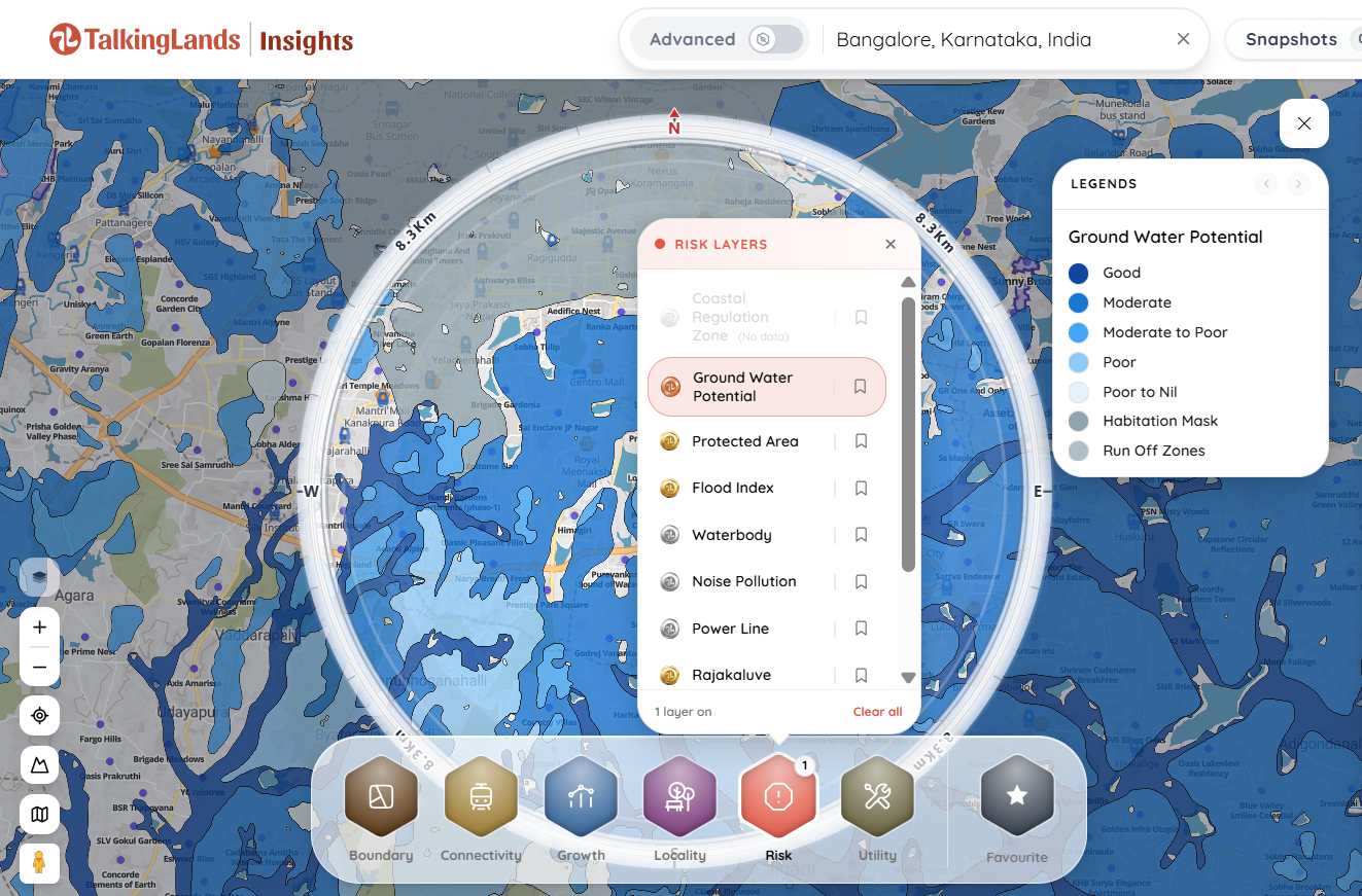
Checking physical terrain and government PDFs is tedious and often inaccurate. The most reliable method in 2026 is to overlay your exact survey number on a digital spatial map. By activating the Ground Water Potential layer, you can instantly see a color-coded rating for the exact polygon you intend to purchase, cross-referenced with nearby waterbodies and recharge zones.
The Bangalore Context: Water Table Depth and Rules
If you are buying land in or around Bangalore, the rules of the game are uniquely challenging. Bangalore sits on the Deccan Plateau, characterized by solid granite and gneiss.
- The Depth Reality: In the 1990s, water was available at 100 feet. Today, in rapidly developing peripheral areas like Mahadevapura, Sarjapur, and Whitefield, the water table depth in Bangalore frequently plunges past 1,000 to 1,500 feet.
- Over-Exploited Groundwater Areas: Large swathes of Bangalore Urban and Rural districts are officially notified as "Over-Exploited" by the CGWB.
- Strict BWSSB Permissions: In Bangalore, drilling a borewell is no longer a fundamental right. Under current rules, you must obtain explicit prior permission from the Bangalore Water Supply and Sewerage Board (BWSSB) or the Ground Water Authority. In over-exploited zones, permissions for new commercial or multi-dwelling residential borewells are routinely denied or heavily delayed.
What to Verify Before Buying (The Checklist)
Before you sign a sale agreement, ensure you have checked the following overlapping factors:
- Ground Water Potential Rating: Is it geologically viable?
- CGWB / BWSSB Status: Is it in a restricted or over-exploited zone?
- The Flip Side (Flood Risk): Plots right next to lakes might have great groundwater, but they could violate the National Green Tribunal (NGT) Lake Buffer zones or sit directly in a flood plain. You must balance groundwater potential against overlapping risks. (Learn how to check if land is in a flood zone).
- Zoning Restrictions: Always verify the local zoning to ensure residential construction is actually permitted on the land you are evaluating.
Common Mistakes Buyers Make
- Trusting a "Water Diviner": Many buyers still rely on individuals walking the plot with coconuts, copper rods, or twigs to "feel" the magnetic pull of water. This is pseudoscience. Rely on hydrogeological data and spatial mapping, not folklore.
- The "Neighbor Fallacy": Assuming that because your neighbor has a high-yielding borewell, you will too. In hard-rock terrains, water flows in isolated fractures. Your neighbor might have tapped a major fissure, while your plot, just 40 feet away, sits on solid, dry granite.
- Ignoring the Legal Classification: Buying land with great water potential, but failing to realize the entire block is legally notified as "Over-Exploited," meaning the government will not grant you a permit to drill.
Map the Water Risk Instantly
You don't need to guess about aquifers or spend weeks hunting down CGWB PDF reports. You can verify the hydrogeological reality of your plot instantly with TalkingLands Insights.
By dropping your exact survey number into our spatial mapping engine, you can overlay your plot's boundary against the Ground Water Potential layer and the Waterbody/Recharge layer. In seconds, you will know if your plot sits on a dry hard-rock ridge or a high-potential recharge zone—empowering you to walk away from a dry investment before you pay the advance.
-p-2000.png)
Frequently Asked Questions
1. How to check groundwater before buying land?
The most accurate method is to map the land digitally. By using spatial intelligence platforms like TalkingLands, you can overlay your exact survey number with official Ground Water Potential layers. You should also check the CGWB classification for the region and physically analyze the terrain for nearby recharge sources like lakes or valleys.
2. What is an over-exploited groundwater area?
An over-exploited zone is a region classified by the Central Ground Water Board (CGWB) where the annual rate of groundwater extraction exceeds the annual rate of natural recharge. In these areas, the water table is dangerously depleted, and the government heavily restricts or completely bans the drilling of new borewells.
3. Do I need permission to drill a borewell?
Yes. In almost all major Indian cities, particularly in states like Karnataka, Tamil Nadu, and Maharashtra, drilling a borewell requires prior statutory permission. In Bangalore, you must obtain a NOC (No Objection Certificate) and permit from the BWSSB or the relevant groundwater authority.
4. If my neighbor's borewell has water, does it mean mine will too?
Not necessarily. In hard-rock geologies like the Deccan Plateau, groundwater is trapped in isolated rock fractures, not continuous underground pools. A neighbor 50 feet away might tap into a deep fracture with high yield, while your drill bit might hit solid, dry rock.
5. How deep are borewells in Bangalore?
There is no universal depth. In older, central areas with better recharge or near specific lakes, water might be found at 200–400 feet. However, in rapidly expanding IT corridors and peripheral layouts, borewell depths routinely exceed 1,000 to 1,500 feet due to massive over-extraction.
6. How can I check the water table depth for a specific area?
You can review historical data reports published by the state groundwater department or the CGWB. For real-time, actionable insights on a specific plot, utilizing spatial mapping tools that cross-reference terrain, waterbodies, and geological potential provides the clearest picture of what depth you might face.
.png)

.png)


