Bengaluru–Chennai Expressway (2026): East Bengaluru's New Growth Corridor & What to Verify
Bengaluru–Chennai Expressway (2026): East Bengaluru's New Growth Corridor & What to Verify
An investor aiming to capitalize on the Bengaluru–Chennai Expressway boom buys a 2-acre plot of "cheap land near the new expressway" in Malur. The broker proudly points out that the property literally touches the boundary of the new highway. The investor expects logistics companies to line up for a lease.
Two years later, the reality of modern infrastructure planning crushes their investment. The new highway is fully access-controlled. Because the investor’s plot is 10 kilometers away from the nearest authorized interchange ramp, vehicles cannot actually enter or exit the highway from the property. Furthermore, a deeper check reveals the plot is classified as an agricultural Green Belt, making it permanently unbuildable for warehousing.
The East Bengaluru corridor's growth was absolutely real, but the specific plot was a devastating trap.
As the Karnataka section of the mega-expressway becomes operational in 2026, land values across Hoskote, Malur, and Kolar are surging. But navigating this corridor requires understanding the strict mechanics of access-controlled highways and Master Plan zoning. Here is your complete 2026 guide to the Bengaluru-Chennai Expressway, the nodes set to boom, and exactly what you must verify before committing your capital.
Quick Answer: The Bengaluru–Chennai Expressway is a ~262 km greenfield, fully access-controlled highway built under the Bharatmala Pariyojana, designed to cut travel time between the two metros to ~2.5–3 hours. As of 2026, its ~71 km Karnataka section (Hoskote–Malur–Bangarpet–Bethamangala) is operational. It is igniting massive industrial and logistics growth across East Bengaluru (Hoskote, Malur, Kolar, KGF). However, land here is a high-risk mix of active Right-of-Way (RoW) acquisition zones, restricted agricultural green belts, and prime industrial land. Because the road is access-controlled, proximity to an interchange—not just the highway—dictates value. Always verify zoning, interchange proximity, and clear title before buying.
What & Where Is the Expressway?
The Bengaluru–Chennai Expressway (NE-7) is not a simple road-widening project; it is a massive, greenfield (built from scratch on a new alignment) infrastructure marvel.
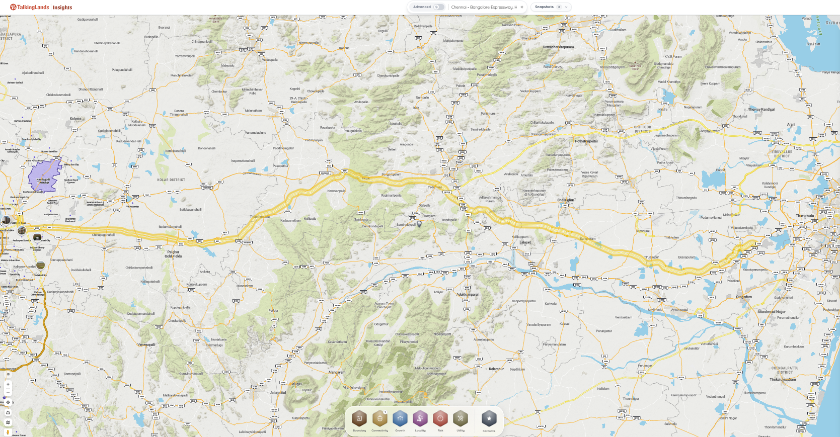
The Route: Starting from Hoskote in East Bengaluru, the Karnataka stretch (~71 km) passes through Malur, Bangarpet, and Bethamangala. It then crosses into Andhra Pradesh (via V Kota and Palamaner) and enters Tamil Nadu (via Ranipet and Kanchipuram) before terminating near Sriperumbudur, Chennai.
The "Access-Controlled" Reality: This is the most misunderstood factor by land buyers. You cannot pull your car off the highway to access a roadside dhaba or warehouse. The highway is fenced off. You can only enter or exit at officially designated interchanges.
The Goal: To handle high-speed vehicular and heavy freight traffic, reducing the traditional 6 to 7-hour commute between South India's two largest economies to under 3 hours.
What's Driving the Corridor — and How to Check It
Understanding the difference between hype and reality requires mapping the economic drivers to actual, verifiable spatial data.
Growth Driver
Insights Layer
Why It Matters
Expressway & Arterial Roads
Connectivity → Highway/Major Roads
Verifies your plot's true driving distance to an authorized interchange ramp.
Bharatmala Corridor
Growth → Bharatmala Project
Indicates proximity to national freight corridors and the STRR (Satellite Town Ring Road).
KIADB Industrial Nodes
Growth → Industrial Corridor / Industries
Confirms if land sits near employment anchors like Hoskote and Narsapura (Kolar).
Master-Plan Zoning
Boundary → Master Plan
Differentiates highly valuable buildable land from restricted agricultural green belts.
Guidance Value
Growth → SRO Guidance Value (Beta)
Helps baseline the government's official land valuation against broker asking prices.
Why East Bengaluru is Booming (The Nodes to Watch)
While the Anekal-Attibele Hosur Road belt dominates South Bengaluru, the East Bengaluru corridor is absorbing massive capital for slightly different reasons: saturation in Whitefield, cheaper large-acreage availability, and massive KIADB expansion.
Hoskote (The Logistics Gateway): Hoskote is the primary anchor. Because it serves as the intersection point for the Bengaluru-Chennai Expressway, the Satellite Town Ring Road (STRR), and the Old Madras Road, it is quickly becoming the undisputed logistics and warehousing capital of Bengaluru.
Malur (Industrial & Affordable Residential): Malur benefits directly from the new alignment. Its existing industrial areas are expanding, and it is absorbing the blue-collar workforce demand priced out of the Whitefield and Kadugodi peripheries.
Kolar / Narsapura (The Mega-Manufacturing Hub): The Narsapura KIADB industrial area in Kolar is a massive employment driver, hosting giants like Wistron (Apple manufacturing), Honda, and Mahindra Aerospace. The expressway supercharges its freight connectivity to Chennai’s ports.
Bangarpet / KGF (The Emerging Fringe): As land prices in Hoskote and Malur peak, long-term investors are looking further down the expressway toward Bangarpet and the Kolar Gold Fields (KGF) region, banking on the state government's plans to revive KGF with new industrial parks.
The Traps: What You MUST Verify
The influx of capital into the Kolar/Malur belt has triggered aggressive, often misleading real estate brokering. Avoid these traps:
The Interchange Illusion: We repeat: an access-controlled expressway has walls. If a broker sells you a plot "touching the expressway" but the nearest interchange is 12 kilometers away, your logistics trucks will have to drive 12 kilometers down a narrow village road just to get onto the highway. Value is dictated by interchange proximity, not physical adjacency to the road boundary.
Inside the RoW / Acquisition Corridor: If you unknowingly buy a private plot that sits inside an active NHAI or KIADB gazetted acquisition boundary, the state will forcefully acquire your land. You will only receive statutory compensation, wiping out any commercial upside.
The Agricultural Green Belt: The vast majority of land along this greenfield alignment is agricultural. If the local Comprehensive Development Plan (CDP) designates your survey number as a Green Belt, securing a DC Conversion for a warehouse is impossible.
Unapproved Layouts: To house the incoming workforce, developers are carving up agricultural land into small, unapproved residential sites (B-Khatas or Panchayati layouts). These lack official town planning approval and cannot secure bank loans
Looking to Invest in East Bengaluru?
From logistics parcels near Hoskote to residential layouts in Malur, share your exact requirements. Our team helps you find and verify legally cleared properties safely outside restricted zones and acquisition corridors.
TalkingLands provides spatial verification and connects you with verified partners — we do not sell plots directly.
How to Verify a Plot on the Expressway Corridor
Protecting your capital on the East Bengaluru fringe requires ruthless spatial and paper due diligence:
Check the CDP Zoning: Ensure your specific survey number is zoned for Industrial, Commercial, or Residential use. Learn how to find the zoning of a property.
Confirm Position vs. Interchange: Digitally overlay your plot to see its true driving distance to the designated Bharatmala expressway interchanges.
Check Acquisition Status: Cross-reference official government gazettes to ensure your survey number is not slated for NHAI or KIADB acquisition.
Validate the Title: Trace the 30-year chain of title and verify ownership via the 7/12 Extract (Satbara) or Karnataka RTC.
How TalkingLands Insights Helps
You cannot confirm if a plot is safely zoned, outside an acquisition boundary, or near an actual interchange by trusting a broker's PDF map.
With TalkingLands Insights, checking your East Bengaluru plot takes seconds. Drop your survey number into the platform to visualize the property on a live satellite map.
You can activate the Connectivity Layer (to view Highways/Major Roads), toggle the Growth Layer (to spot the Bharatmala Project and Industrial Corridors), and utilize the Boundary Layer (to map Master Plan zoning and survey numbers). This gives you total visibility into whether a plot is on a real corridor, near a usable ramp, and legally buildable.
Is Your Plot on a Genuine Growth Corridor?
Buying near the Bengaluru–Chennai Expressway? Check if a plot is near an interchange, zoned to build, and outside the acquisition corridor — drop a survey number to see the truth. Sign up free and get 5,000 free coins to map your plot instantly.
As of 2026, the ~71-kilometer Karnataka section (connecting Hoskote, Malur, Bangarpet, and Bethamangala) is operational. The full ~262-kilometer stretch extending through Andhra Pradesh and Tamil Nadu into Chennai is targeted for phased completion by mid-2026, subject to final infrastructure and safety clearances.
2. What is the route of the Bengaluru-Chennai Expressway?
It is a greenfield alignment. In Karnataka, it starts at Hoskote and travels through Malur and Bangarpet to Bethamangala. It then passes through V Kota and Palamaner in Andhra Pradesh, and Ranipet and Kanchipuram in Tamil Nadu, terminating near Sriperumbudur outside Chennai.
3. Which areas benefit from the Bengaluru-Chennai Expressway?
In Karnataka, the primary beneficiaries are the East Bengaluru nodes: Hoskote, Malur, Kolar (Narsapura), and Bangarpet/KGF. These areas are seeing massive capital inflows for warehousing, heavy industry, and affordable residential layouts.
4. Is land near the expressway a good investment?
Yes, but only if selected precisely. Because it is a massive freight and logistics corridor, land situated near the designated interchanges (for easy truck access) and zoned for industrial or commercial use in the Master Plan will see the highest appreciation.
5. Can you access the expressway from any plot touching it?
No. The Bengaluru-Chennai Expressway is fully access-controlled. It is fenced off, meaning you cannot physically enter or exit the highway from a roadside property. You can only enter the highway via specific, officially constructed interchange ramps.
6. How can I verify a plot near the Bengaluru-Chennai Expressway?
You must independently verify the plot's survey number against the Comprehensive Development Plan (CDP) for zoning, measure its true driving distance to an interchange, and ensure it is not listed in any active NHAI or KIADB acquisition gazettes. Platforms like TalkingLands Insights allow you to instantly overlay your survey number against these active spatial layers.
.png)
.png)



-p-2000.png)
.png)

.png)
