Key takeaways
- The Ministry of Civil Aviation's 2015 height restriction rules (G.S.R. 751(E)) control structures within 20 km of an aerodrome reference point.
- AAI's Colour Coded Zoning Maps give a permissible top elevation, in metres above mean sea level, for each grid around an airport.
- Maximum building height = permissible top elevation minus your site's ground elevation. Rooftop tanks, lift rooms and antennas count.
- Site coordinates and elevation must come from a qualified surveyor and match your application exactly; mismatches are a common reason for rejection.
- Defence airfields follow separate rules. Near Yelahanka in Bengaluru, Realm's screening shows an IAF NOC is needed at any height.
- Realm screens any site in seconds: ground elevation, permissible height, approximate floors and a 3D view of the airport surfaces.
How tall can you build on this site?
A screening estimate, not an NOC. Nothing you type is sent anywhere.
A developer buys land 8 km from an airport, gets a plan for G+18 approved in principle, and then learns the site's height limit allows about G+13. Five floors of revenue disappear before construction starts. Airport height clearance is one of the few rules that can cut a project's size by a third, and the number that decides it is published long before you buy. This guide explains NOCAS, the AAI NOC process, and how to check a site's height limit in minutes.
What NOCAS is
NOCAS (No Objection Certificate Application System) is the Airports Authority of India's online system for height clearance. Builders and owners use it to view the Colour Coded Zoning Maps around civil airports and to apply for an NOC for buildings, towers, chimneys and other structures. Applications for civil aerodromes are processed at AAI's regional NOC offices.
The 20 km rule and Colour Coded Zoning Maps
The Ministry of Civil Aviation (Height Restrictions for Safeguarding of Aircraft Operations) Rules, 2015, notified as G.S.R. 751(E) on 30 September 2015, control structures and trees within a radius of 20 km from an aerodrome reference point (ARP). The space around a runway is protected by imaginary surfaces: the approach and take-off funnels, the inner horizontal surface, the conical surface and the outer horizontal surface. Your building must stay below all of them.
AAI turns those surfaces into a Colour Coded Zoning Map (CCZM): a grid around the airport where each coloured cell carries a permissible top elevation above mean sea level (AMSL). Where a CCZM exists, local authorities can approve buildings within the heights it shows; above them, or where the authority asks for it, you need an NOC from AAI.
The height formula
Two things catch people out. First, the limit is an elevation above sea level, not a height above your plot, so a plot on higher ground gets a lower building. Second, the limit applies to the top of everything: overhead tanks, lift machine rooms, mumty, antennas and lightning arresters. Use the calculator above to see what that does to your floor count.
Ground elevation is where a terrain check helps. Our guide to contour maps and elevation explains how to read the ground level across a plot, which can vary by several metres on a large site.
When you need what
| Situation | What usually applies | Where |
|---|---|---|
| Within 20 km of a civil airport, building within the CCZM height | Approval by the local authority within the CCZM height | Local planning authority, using AAI's CCZM |
| Within 20 km, no CCZM or building above it | Height NOC from AAI | NOCAS, then AAI's regional NOC office |
| Near a defence airfield | NOC from the defence authority concerned | Air Force, Army or Navy, as notified |
| Telecom masts and towers | NOC through NOCAS, with data matching the SACFA application | NOCAS |
| Outside 20 km | Check local rules for very tall structures | Local authority |
How to apply on NOCAS
- Get a site elevation certificate from a qualified surveyor: WGS-84 coordinates of the site corners and the ground elevation in metres AMSL.
- Check the CCZM on NOCAS for your coordinates and note the permissible top elevation.
- Fix the design height, including every rooftop structure, so the top elevation stays within the limit.
- Register and apply on NOCAS with the coordinates, site elevation, structure height and top elevation exactly as certified.
- Submit the documents the regional office asks for, usually the surveyor's certificate, site plan and photographs.
- Track the application and download the NOC, which states the permissible top elevation and its validity period.
Validity is printed on the NOC. Published AAI NOCs we have seen state 8 years, with revalidation possible in limited cases if construction has started; check your own certificate and the current guidelines.
Two real sites, screened in Realm
Realm's Airport Zone tool screens any parcel for civil and defence airport limits. Here are two Bengaluru sites from our walkthrough.
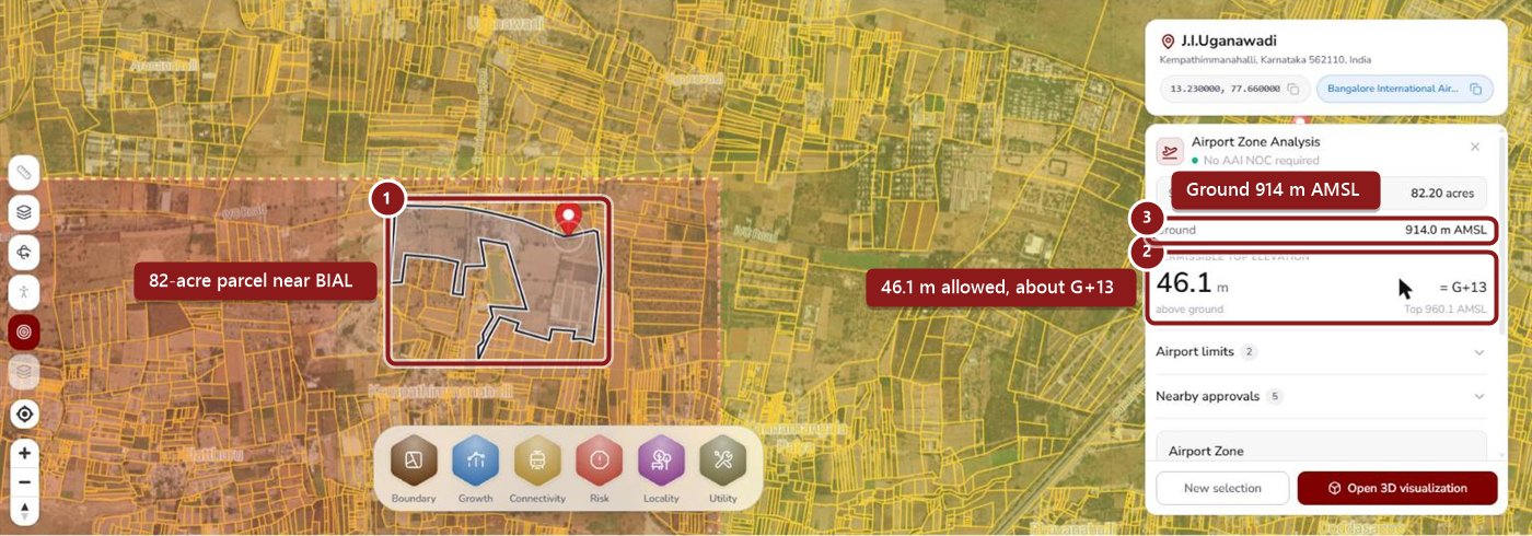
- 1The selected parcel, inside the BIAL airport zone and planning area.
- 2Permissible top elevation works out to 46.1 m above ground, about G+13, with a ceiling of 960.1 m AMSL.
- 3Ground elevation: 914 m AMSL. That is the number to confirm with your surveyor.
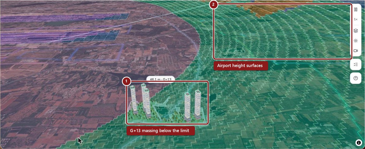
- 1G+13 towers drawn at the permissible height, sitting just under the surface.
- 2The airport's height surfaces, coloured by zone, rising away from the runway.

- 1The parcel, inside the defence zoning around Yelahanka.
- 2Result: an IAF NOC is required at any height, so even a low building needs defence clearance.
- 3Ground elevation: 919 m AMSL.
Why applications get rejected
For Bengaluru specifically, see our guide to building height restrictions near Bengaluru airport, and for upcoming airports, Bengaluru's second airport and Purandar airport in Pune.
Know the height limit before you buy the land
Realm screens civil and defence airport limits for any parcel: ground elevation, permissible height, approximate floors and a 3D view, alongside land records and zoning.
Book a Realm demoFrequently asked questions
NOCAS is the No Objection Certificate Application System of the Airports Authority of India. Builders and owners use it to apply for height clearance for buildings and other structures near civil aerodromes and to view the Colour Coded Zoning Maps.
The Ministry of Civil Aviation's 2015 height restriction rules control structures within 20 km of an aerodrome reference point. Where a Colour Coded Zoning Map exists and the building stays within its permissible height, local authorities can approve the building within those heights; otherwise, or where the authority asks for it, you apply to AAI through NOCAS. Check the current rules and your local authority's requirements.
It is a map prepared and certified by AAI that divides the area around an airport into colour-coded grids, each with a permissible top elevation above mean sea level.
Subtract your site's ground elevation above mean sea level from the permissible top elevation for your location. The result is the maximum height above ground, and it must include everything on the roof, such as water tanks, lift rooms and antennas.
Common reasons are documentation errors, such as site coordinates or site elevation in the application not matching the surveyor's certificate, wrong coordinate formats, and a proposed top elevation above what is permissible for the location.
Yes. Defence aerodromes such as Air Force stations follow defence rules, and clearance comes from the defence authority concerned, not only from AAI. Near Yelahanka in Bengaluru, for example, Realm's screening shows that an IAF NOC is needed at any height.
This article is general information, not legal or aviation advice. Height rules, zoning maps and NOC procedures change; check the current rules on AAI's NOCAS portal and with your planning authority. Realm results shown are screening estimates from a TalkingLands demo account in November 2026, not NOCs.