Key takeaways
- There are three kinds of real estate virtual tour: 360° photo tours, rendered 3D walkthrough videos and interactive 3D master plans.
- 360° tours need a real space to photograph, so they suit sample flats and ready projects.
- Walkthrough videos show the design beautifully but cannot answer "is this unit still available, and at what price?"
- An interactive 3D master plan on satellite imagery shows the location, towers, units, plans, availability and price, and can stay current as inventory changes.
- A virtual tour does not replace the site visit; it makes buyers arrive knowing which unit they want.
- Reveal builds the interactive version on a live map and connects it to booking and site visit requests.
Which virtual tour does your project need?
Pick one answer per question. Nothing you choose is sent anywhere.
1. Project stage
2. What buyers ask about most
3. How often does your inventory or pricing change?
4. Project type
A buyer in Pune is looking at a project in Bengaluru. A brochure shows towers in a perfect sunset. A video shows a sample flat. Neither answers the three questions the buyer actually has: where exactly is it, which unit is still available, and what will it cost? A good real estate virtual tour answers all three before anyone gets on a flight.
What a real estate virtual tour is
A virtual tour is any way for a buyer to explore a property online before visiting. For developers, the useful question is not whether to have one, but which kind, because each kind answers different questions and needs a different amount of work to keep up to date.
The three types compared
| Type | What the buyer sees | Before construction? | Live availability and price? | Keeping it current | Best for |
|---|---|---|---|---|---|
| 360° photo tour | Panoramic photos of a real room or site | No, the space must exist | No | Re-shoot when the space changes | Sample flats, ready homes, clubhouses |
| 3D walkthrough video | A rendered fly-through of the design | Yes | No | Re-render for design changes | Launch films, ads, brand |
| Interactive 3D master plan | Towers, floors and units the buyer can click, on a real map | Yes | Yes, when linked to inventory | Updates with the inventory | Selling specific units, plots and phases |
Most projects end up using more than one: a walkthrough film for the launch, a 360° tour of the sample flat, and an interactive master plan as the place where buyers actually choose. The mistake is using the first two to do the third one's job.
What buyers need to see
- Location: the project on real satellite imagery, with the roads, schools, hospitals and highways around it.
- The master plan: towers or plots, open spaces and amenities, in their real positions.
- The unit: tower, floor, facing, the floor plan, and both carpet and super built-up areas.
- Availability and price: whether that unit is still open, and what it costs. See our guide to the cost sheet format for what the price should include.
- A next step: book a site visit, or reserve the unit.
Inside a 3D project tour on Reveal
Here is what a buyer sees when they open a Reveal project page, from a demo project in our walkthrough. The map is real satellite imagery; the towers, units and pins are placed from the project's own master plan.
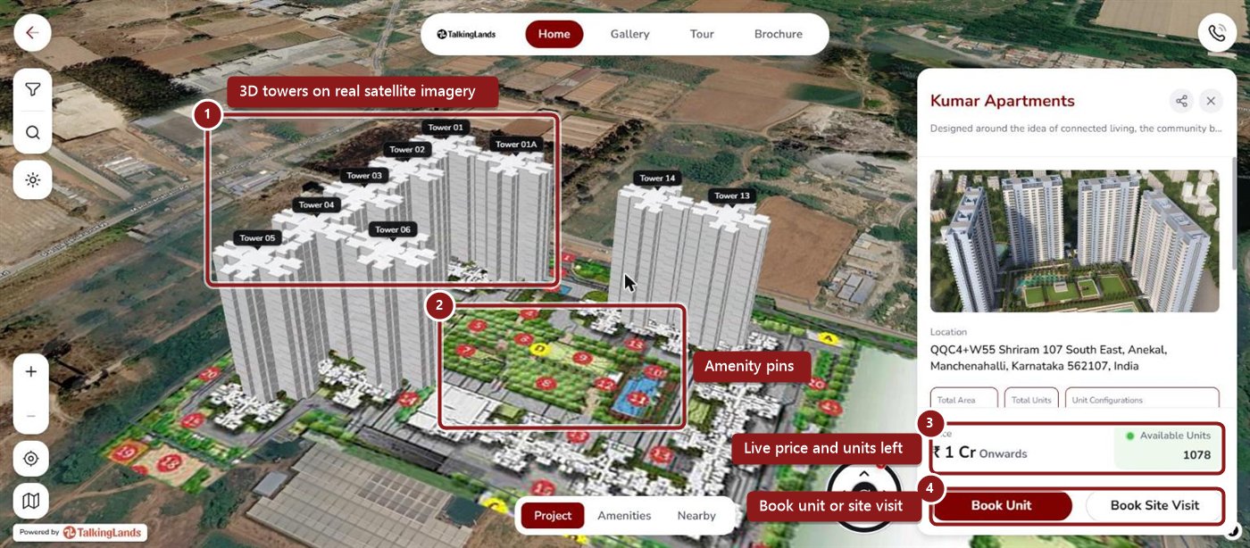
- 1Every tower, labelled, in its real position. The buyer can rotate, tilt and zoom.
- 2Numbered amenity pins in the landscape, from the master plan.
- 3Starting price and the number of units still available.
- 4Book Unit and Book Site Visit, always one tap away.
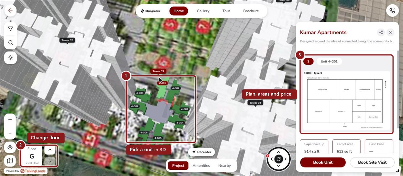
- 1The units on the chosen floor, drawn in 3D. Tap one to select it.
- 2Move up and down the floors.
- 3The unit card: configuration, floor plan, super built-up and carpet area, and base price.
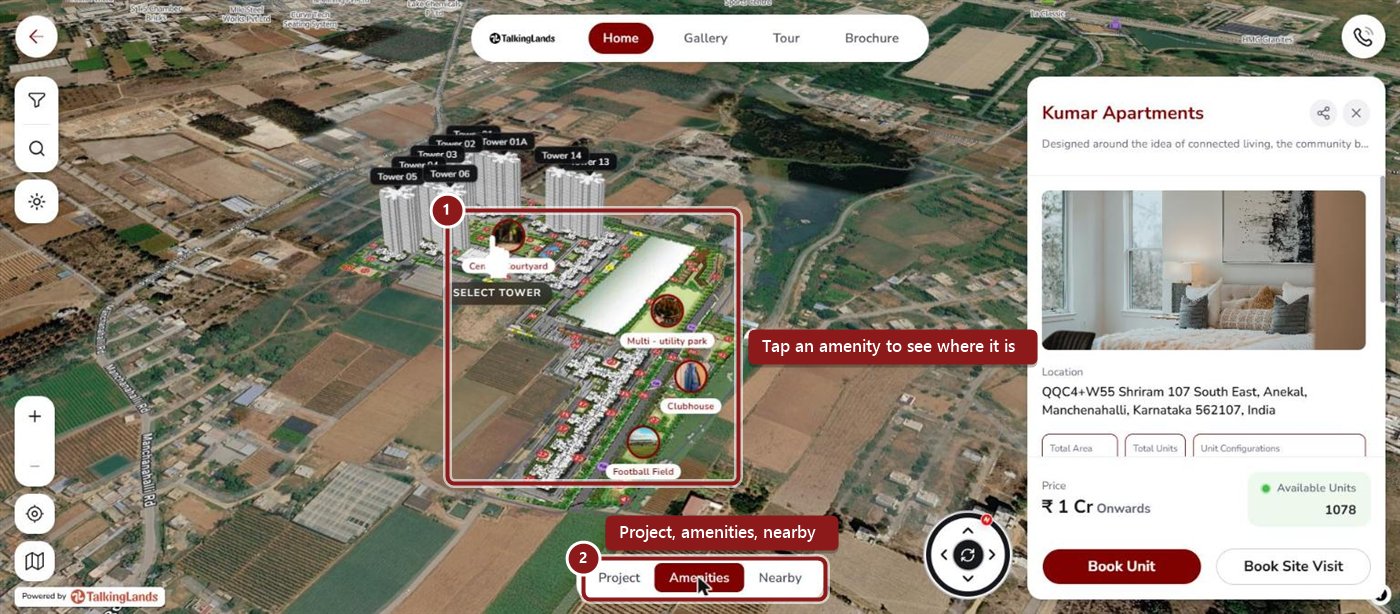
- 1Each amenity as a photo pin in its real place: courtyard, park, clubhouse, football field.
- 2Switch between Project, Amenities and Nearby.
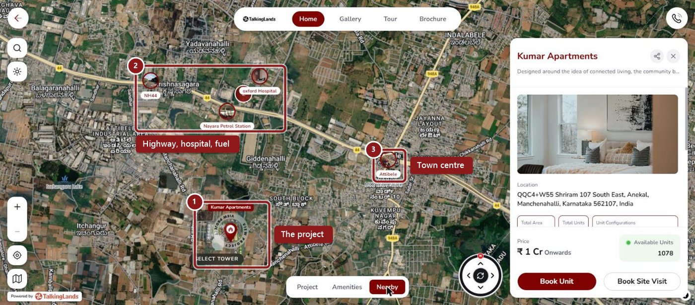
- 1The project, so the buyer never loses their bearings.
- 2The highway, a hospital and a fuel station, pinned by the developer.
- 3The nearest town centre.
From tour to site visit
The tour's job is to produce a confident site visit. On a Reveal project page, Book Site Visit opens a short form: name, mobile number or email, number of people, date and time, and comments. Because each buyer opens the project from their own link, the sales team also sees what they looked at before they arrived. Our guide to real estate lead generation for builders covers how that link is created and tracked.
How to set up an interactive 3D tour
- Place the site: upload the project boundary so it sits on the map in the right place.
- Add the master plan: towers with their floors, or plots, plus roads and open spaces.
- Load the units: unit numbers, configurations, floor plans, areas and status.
- Add pricing so every unit shows the right price.
- Pin amenities and nearby places, with photos.
- Add media: gallery, brochure, and any 360° or walkthrough links.
- Share personal links with buyers, and watch who opens what.
Mistakes to avoid
For the bigger picture of selling a project online, see our guides to property microsites, real estate sales software and the digital twin of a property.
Let buyers choose their unit before they visit
Reveal puts your towers, units, amenities and neighbourhood on a live 3D map, with prices, availability and a booking button on every screen.
Book a free demoFrequently asked questions
It is an online way for a buyer to explore a property before visiting: a 360-degree photo tour, a rendered 3D walkthrough video, or an interactive 3D master plan where the buyer can pick a tower, floor and unit.
A 360 tour is made from panoramic photos of a real space, so the space must exist. A 3D virtual tour is built from a 3D model, so it can show a project before it is built, and an interactive 3D model can also connect to unit data such as plans, areas and availability.
Yes, with renders or a 3D model. A rendered walkthrough video shows the design; an interactive 3D master plan on a map also lets the buyer choose a unit and see its plan, area, price and whether it is still available.
No. It shortlists. A good virtual tour helps buyers arrive at the site already knowing the tower, floor and unit they want, which makes the visit shorter and more likely to end in a booking.
The location and neighbourhood, the master plan and amenities, the tower and floor, the unit plan with carpet and built-up areas, live availability and price, and a clear way to book a site visit or the unit.
Reveal places the project's master plan, towers and units on satellite imagery, adds amenity and nearby pins, media and tour links, and connects each unit to its plan, area, price and status. Buyers open it from a personal link and can book a site visit or unit from the same page.
Screens shown are from a demo project in a TalkingLands Reveal account in November 2026; project names, images and numbers in the demo are for illustration. Features can change, so confirm them in a demo.