.png)
Solur Township Bangalore: Location, Status & Investor Guide (2026)
The "Next Bidadi" Trap
If you are an investor looking at the fringes of Bengaluru right now, your phone is likely buzzing with WhatsApp messages from brokers pitching a new goldmine. The pitch usually goes like this: "Bidadi is already too expensive. The government is building a massive new smart city in Solur next. Buy this half-acre agricultural plot now for cheap, and flip it to developers for 5x the price when the township gets built."
The hype is partially true—Solur Township is indeed one of three massive integrated satellite cities proposed by the state government to decongest Bengaluru.
But the trap lies in the timeline and the execution. Buying land inside a proposed government township before the final master plan is frozen is often a one-way ticket to a decade-long legal headache. If the government acquires your plot for the project, you don't hit the jackpot—you get locked into a protracted compensation process.
Whether you are a retail investor looking for early-stage appreciation or a developer scouting the North-West corridor, this is the definitive 2026 guide to the proposed Solur Township: where it is, its current status, the very real acquisition risks, and what you must verify before paying an advance.
Quick Answer: Solur Township is a proposed integrated "work-live-play" satellite city in the Ramanagara district, located north-west of Bengaluru near NH-75 and the STRR. It is part of the BMRDA’s three-township plan (Bidadi, Solur, Nandagudi). However, Solur is currently in the early planning stages. Buying land here carries severe acquisition risks—you must map your exact survey number to ensure it is not locked under preliminary government acquisition notifications.
What is Solur Township?
To understand Solur, you have to understand Bengaluru’s breaking point. The core city is choking, and expanding the outer rings is no longer enough. To survive the next two decades, the state revived a two-decade-old master plan to build entirely new, self-sustaining satellite cities far beyond the current urban limits.
Spearheaded by the Bangalore Metropolitan Region Development Authority (BMRDA) and the newly formed Greater Bengaluru Development Authority (GBDA), the state has shortlisted three regions for these mega-projects: Bidadi, Solur, and Nandagudi.
Solur Township is proposed as an Integrated "Work-Live-Play" Township.
Unlike traditional layouts that only build houses and force residents to commute 30 kilometers into the city for work, an integrated township is designed to be a standalone micro-economy. The Solur blueprint targets a mix of logistics parks, commercial high-rises, data centers, and residential blocks, all powered by sustainable solar grids and integrated public transit.
Where is it Located?
Solur sits in the Ramanagara district, situated to the north-west of Bengaluru.
Its geography is highly strategic. Positioned roughly along the Nelamangala–Magadi–Kunigal belt near NH-75 (the Bangalore-Mangalore Highway), Solur benefits from massive upcoming infrastructure. A major factor reportedly driving Solur’s selection is its expected integration with the under-construction Satellite Town Ring Road (STRR).
The STRR will act as a high-speed bypass connecting Solur directly to Hosur, Devanahalli, and Doddaballapura without ever touching the congested Bengaluru city center. Furthermore, the BMRDA has reportedly requested Namma Metro and the BWSSB to conduct feasibility studies to explore extending mass transit and potable water lines directly to the Solur region.
Bangalore's 3 Integrated Townships at a Glance
.png)
Current Status: Proposed, Not Finalized
If a broker tells you that the Solur Township is "approved and construction starts next month," they are lying to you.
While the state cabinet has given sweeping approvals to the Greater Bengaluru Integrated Satellite Town framework, Bidadi is the designated pilot project. The government has already deployed land acquisition officers and approved the acquisition of thousands of acres for Bidadi.
Solur, on the other hand, remains in the proposed and early-planning stages. The groundwork, including Detailed Project Reports (DPRs) and social impact assessments, is still being mapped out. This means the exact boundary of the Solur Township has not been permanently frozen, which creates a massive window of regulatory ambiguity.
(To understand the momentum of the pilot project, read our deep dive on the Bidadi Smart City (GBIT) Project Update).
The Land Acquisition Trap (The Real Risk)
Here is the uncomfortable reality of investing in Solur right now: building an integrated township requires assembling massive, contiguous tracts of land—often thousands of acres. The government cannot buy this on the open market; they acquire it from local farmers and landowners using statutory powers.
To minimize cash payouts, the state often utilizes a Land Allocation Model (similar to the Amaravati model or the Kempegowda Layout format). Under this framework, if the government acquires your 1-acre plot, they don't pay you market value in cash. Instead, they typically use a land-pooling model where owners receive a share of developed land back as a residential or commercial site once the township is complete.
This creates a terrifying scenario for retail buyers:
- The Freeze: Once a preliminary notification for acquisition is issued on a survey number, that land is legally frozen. You cannot build on it, you cannot sell it, and banks will not touch it.
- The Waiting Game: Township development timelines in India routinely stretch past 10 to 15 years. If your plot is acquired, your capital is locked in a holding pattern until the government finally allots you your developed piece of the pie.
- The Broker Dump: Local speculators often try to sell off agricultural land that they know is slated for acquisition to unsuspecting retail buyers from Bengaluru, letting the new buyer deal with the legal freeze.
Invest or Wait? The Verdict
Solur represents classic high-risk, high-reward frontier investing.
The Upside: If you purchase a clear-titled plot immediately outside the official acquisition boundary of the future township, you stand to make a fortune. You will benefit from the massive STRR infrastructure, the Namma Metro extension, and the inevitable commercial spillover, without your land being frozen by the state.
The Downside: If you accidentally buy inside the proposed master plan boundary, your investment becomes a multi-year legal waiting game.
For retail buyers, the safest play is to hold off on direct land purchases in Solur until the final Comprehensive Development Plan (CDP) and the exact acquisition boundaries are gazetted. For developers and institutional funds with high risk tolerance, early land banking on the immediate periphery of the STRR intersections is a calculated, strategic bet.
What Buyers MUST Verify Before Paying an Advance
If you are determined to invest in the Solur/Ramanagara belt right now, manual due diligence is not enough. You must run a strict compliance check on your exact survey number:
- Acquisition Notifications: Check the local KIADB (Karnataka Industrial Areas Development Board) and BMRDA notifications. Is the survey number currently flagged for the integrated satellite town project?
- Master-Plan Zoning: Even if it escapes the township acquisition, is the plot designated as a permanent agricultural Green Belt under the local planning authority? (Learn more about Land Acquisition Due Diligence Checklists).
- Environmental Buffers: Ramanagara district is ecologically sensitive. Verify that your plot does not fall into overlapping lake buffers, forest buffers, or high-tension power line setbacks. (See our guide on How to Find Risk Associated with Land).
Map the Township Risk Instantly
Relying on broker promises and outdated PDF maps will leave your capital exposed. You cannot afford to guess where the government plans to draw the Solur boundary line.
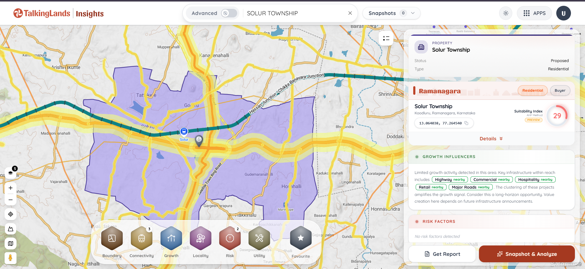
This is exactly why TalkingLands Insights was built. By dropping your exact survey number into our spatial mapping engine, you can overlay your plot's cadastral boundary onto a live satellite map.
Activate the Proposed CDP & Planning Authority layers to see precisely where your targeted land sits in relation to infrastructure corridors, growth signals, and high-risk acquisition zones. Disqualify restrictive parcels in seconds and protect your capital from the township trap.
-p-2000.png)
Frequently Asked Questions
1. What is Solur Township?
Solur Township is a proposed integrated satellite city located in the Ramanagara district, north-west of Bengaluru. It is part of the state government's initiative to build self-sustaining "work-live-play" communities outside the core city limits to alleviate urban congestion.
2. Is the Solur Township project officially approved?
While the broader concept of creating integrated townships (including Bidadi, Solur, and Nandagudi) has received top-level state backing, Bidadi is currently the only one acting as the active pilot project. Solur is still in the early planning and feasibility stages, meaning the final blueprints and exact land borders are not yet frozen.
3. Where exactly is the Solur integrated township located?
It is located near the Solur hobli in the Ramanagara district. Strategically, it sits near NH-75 (the Bengaluru-Mangaluru highway) and heavily leverages the upcoming Satellite Town Ring Road (STRR) to ensure seamless connectivity bypassing the main city.
4. Is it safe to buy land in Solur right now?
It carries high risk. Because the exact master plan boundaries are not finalized, buying agricultural land right now means you risk purchasing a plot that the government will soon freeze for mandatory acquisition. The safest strategy is to wait for the final CDP or use spatial data to buy securely on the township's immediate periphery.
5. How does Solur compare to Bidadi and Nandagudi?
Bidadi is the most mature of the three, with land acquisition already underway and strong backing as the pilot "smart city" project. Solur is positioned as a future logistics and commercial hub tied to the STRR. Nandagudi, located in the east near Hoskote, is being strategically aligned with the Bengaluru-Chennai Expressway corridor.
6. Will Namma Metro connect to Solur Township?
The BMRDA has reportedly requested Namma Metro to conduct feasibility studies to explore extending metro connectivity to these new satellite towns, including Solur, to ensure they remain accessible without private vehicles. However, final metro alignments are years away from execution.
.png)

.png)


