.png)
Bengaluru Suburban Rail 2026: Which Corridor Is Getting Built First (and Where to Buy Land Now)
Two land buyers, working with the exact same budget in the exact same year, make their investments. One purchases a plot near a station on a corridor that is actually under construction-viaducts are going up, and heavy civil contracts have been awarded. The other buyer secures land on a corridor that looks identical on the master map but is hopelessly stuck in the tender stage, with absolutely no work started on the ground.
On paper, both plots are proudly marketed as being "near the Bengaluru Suburban Rail." In reality, one investment has a five-year head start on capital appreciation, while the other is trapped in an indefinite waiting game.
Here is the inconvenient truth that glossy real estate brochures will not tell you: as of 2026, the Bengaluru Suburban Railway Project has 0 km operational. Roughly 55 km of its expansive ~149 km network is actively under construction, while the vast majority remains effectively on paper. The four corridors are moving at drastically different speeds.
If you are buying land based on the suburban rail story, which specific corridor you choose dictates your returns far more than the overall story itself. This guide overlays the critical element of timing onto our comprehensive BSRP map and impact guide, helping you navigate where to buy right now.
Quick Answer: As of 2026, the Bengaluru Suburban Railway Project (BSRP) - a ~149 km, four-corridor network developed by K-RIDE - has 0 km operational. Roughly 55 km is actively under construction, while the remainder sits in the tender and planning phases. Corridor 2 (Mallige) and Corridor 4 (Kanaka) are the furthest along, with civil contracts awarded and station work visibly underway. Meanwhile, Corridors 1 (Sampige) and 3 (Parijaata) remain significantly earlier in the pipeline. For land buyers, targeting a corridor that is actually under construction-and verifying a plot's precise distance from a confirmed station rather than falling inside an acquisition buffer zone-matters infinitely more than proximity to a line drawn on a map.
Bengaluru Suburban Rail Status in 2026 - The Honest Picture
The Bengaluru Suburban Railway Project is a massive commuter rail initiative designed to integrate the city's dense urban core with its outer satellite towns. Managed by K-RIDE (Rail Infrastructure Development Company (Karnataka) Ltd), the ~149 km, four-corridor network was officially approved in 2020 with an estimated capital outlay of ~₹15,767 crore.
However, tracking its true progress requires looking past the political announcements.
- The Ground Reality: As of late 2026, 0 km of the network is operational. Approximately 55 km of the alignment is undergoing active construction, while a staggering ~94 km remains locked in the tender and administrative clearance phase.
- The Timelines: The Union Minister of State for Railways has reportedly targeted partial completion for specific priority corridors by December 2026. While this signals strong government intent, seasoned investors know to treat this as an aggressive target rather than an absolute operational guarantee.
The Four Corridors, Ranked by How Far Along They Are
Evaluating land potential is about sequencing. To maximize the velocity of your capital, you must align your entry with the corridors experiencing genuine physical momentum.
Ahead: Contracts Awarded & Under Construction
- Corridor 2 - Mallige (Baiyyappanahalli–Chikkabanavara, ~25 km): This corridor serves as a major bypass for central congestion. Following an earlier contractor exit, fresh civil contracts for Corridor 2 were awarded in April 2026, and intense contractor mobilization is physically visible on the ground. This makes it one of the most derisked lines for near-term real estate plays.
- Corridor 4 - Kanaka (Heelalige–Rajanakunte, ~46 km): The longest line in the network, Kanaka forms a critical spine connecting East Bengaluru (Bellandur, Marathahalli) down to the industrial powerhouse of Bommasandra. Station work and significant civil construction are actively underway, positioning it alongside Mallige as a top priority for early commissioning.
Earlier: Tendering & Planning Phase
- Corridor 1 - Sampige (KSR Bengaluru–Devanahalli, ~41 km): This highly anticipated line connects the central city to the airport region. While it carries phenomenal long-term transformative potential for North Bengaluru land, it remains in the very early construction and tendering phases. Buyers here must possess patient capital.
- Corridor 3 - Parijaata (Kengeri–Whitefield, ~35 km): Despite linking two massive employment hubs across the East-West axis, Parijaata is the slowest-moving corridor. Major execution contracts remain pending, as authorities prioritize capital expenditure on Corridors 2 and 4.
What "0 km Operational" Means for Your Money
In real estate, infrastructure appreciation does not move in a straight, linear line. It front-loads heavily around visible progress, not initial political announcements.
When a project has "0 km operational," it presents both the highest commercial upside and the highest timeline risk. The moment heavy machinery arrives, concrete viaducts span the road, and station structures become unmistakable physical realities, local land markets aggressively price in the train's arrival.
If you purchase land near Corridors 2 or 4 today, your holding period is aligned with this visible, momentum-driven phase. If you buy land near Corridors 1 or 3, you are locking your capital into a much longer, speculative holding cycle where physical progress may not be seen for years. Match your entry point to a corridor that is actually moving.
"Near the Station" is a Trap Without the Numbers
Because the BSRP is a broad-gauge commuter rail network rather than an intra-city metro, its stations are placed much further apart-often 5 to 8 kilometers between stops.
For investors, this spatial reality is critical. The sweet spot for land value is proximity to a confirmed station catchment. If your land physically abuts the railway tracks but sits 4 kilometers away from a station, your property gains the noise and dust of passing trains, but absolutely zero transit utility.
Furthermore, you must rigorously distinguish a plot inside a viable station-catchment from one trapped inside a K-RIDE buffer or land acquisition zone. As detailed in our comprehensive Land Due Diligence Checklist, any private property situated inside an infrastructure right-of-way will eventually be acquired by the government, effectively eliminating your commercial development upside.
How to Verify a Plot Near the BSRP (Bengaluru)
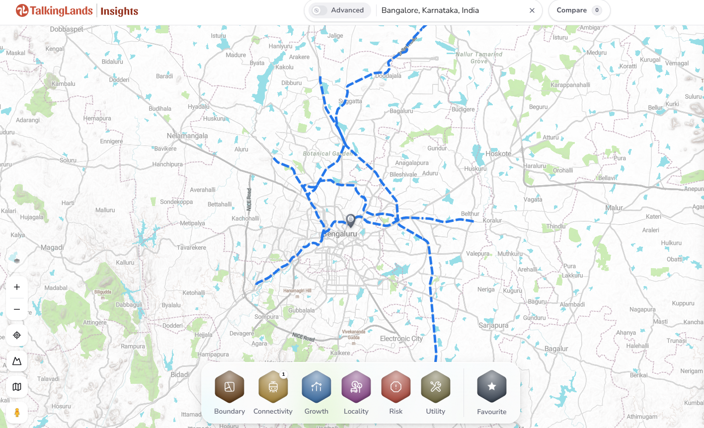
Because Bengaluru's spatial and revenue data is heavily digitized, investors no longer have to rely on a broker's verbal assurances. You can verify exactly where your plot sits relative to the suburban rail matrix before paying a premium:
- Corridor & Station Status: Confirm exactly which of the four corridors your land sits on, and whether it is actively under construction or merely proposed.
- Distance to Alignment & K-RIDE Buffers: Measure the precise spatial distance from your survey number to the K-RIDE alignment to guarantee it safely clears the acquisition zone.
- CDP Zoning: Check the official Comprehensive Development Plan (CDP) zoning to ensure the land is marked for residential or commercial use, rather than being locked in an agricultural green belt.
- RTC Ownership & Title: Pull the live Karnataka RTC (Pahani) to ensure the seller has flawless, unencumbered ownership.
- Layout Approval: If buying a plotted development near a station, ensure the layout possesses official planning authority (BMRDA/BDA) approval.
BSRP Corridors: 2026 Build Status at a Glance
.png)
-p-2000.png)
Frequently Asked Questions
1. What is the status of the Bengaluru Suburban Rail in 2026?
As of 2026, the Bengaluru Suburban Railway Project (BSRP) comprises ~149 km across 4 corridors. Roughly 55 km of the network is actively under construction, while the remainder is in the tendering and planning stages. Currently, there are 0 km of the network operational.
2. Which BSRP corridor will be completed first?
Corridor 2 (Mallige) and Corridor 4 (Kanaka) are reported to be the furthest along in their execution lifecycles. Both have secured major civil contracts, and active station and viaduct construction are visibly underway across their alignments.
3. When will the Bengaluru Suburban Rail start?
Partial operations on the priority corridors have been aggressively targeted by the Ministry for around December 2026. However, buyers should treat this as a strong government intent rather than a confirmed opening date, as major rail infrastructure timelines are inherently fluid.
4. Is it good to buy land near the Bengaluru Suburban Rail?
Yes, provided you buy precisely within the confirmed catchment area of a station on a rapidly moving corridor (like Mallige or Kanaka). Purchasing land on tender-stage lines ties up capital indefinitely, and buying land trapped within the alignment's acquisition buffer will result in your land being acquired rather than developed.
5. How far is safe from the BSRP alignment?
Station-catchment proximity (generally within a 1-to-2 km radius of an approved station) is excellent for capital appreciation. However, land that directly intersects the K-RIDE alignment and its designated buffer/acquisition zone is unsafe, as it is marked for government procurement. You must verify spatial safety on a per-plot basis.
6. How do I check land near a BSRP station?
To thoroughly evaluate a plot, use digital mapping tools like TalkingLands Insights to measure the exact distance from the survey number to the K-RIDE buffer and nearest station. Simultaneously, cross-reference the plot's CDP zoning to ensure buildability and pull the live RTC to confirm clean ownership and title.
.png)

.png)


