.png)
How to Check RTC (Pahani) Online in Karnataka: Bhoomi Guide (2026)
The Agricultural Title Trap
You have identified a beautiful, two-acre agricultural plot just outside the city limits. The seller introduces himself as the sole owner, hands you a neatly folded paper copy of the land record, and points out the physical boundary stones. The paperwork looks official, the deal seems straightforward, and you are ready to write the advance check.
Before you do, your lawyer pulls the live digital record from the government portal. The screen tells a completely different story.
The paper record you were shown was five years old. The live digital record reveals that the land was recently partitioned among four brothers—meaning the seller only owns half an acre, not two. Furthermore, a massive crop loan has been registered against the property, which you would have inadvertently inherited upon purchase.
When you buy rural, agricultural, or unconverted land in Karnataka, the RTC (Record of Rights, Tenancy and Crops)—commonly known as the Pahani—is the ultimate source of truth. Relying on an outdated paper copy or a broker's verbal assurance is a direct path to a financial nightmare.
Whether you are looking to build a farmhouse or acquire raw land for future DC Conversion, this is the definitive 2026 guide to understanding the Karnataka RTC, how to read its complex columns, how to check it online, and the fastest way to trace ownership, legal disputes, and spatial risk in a single scan.
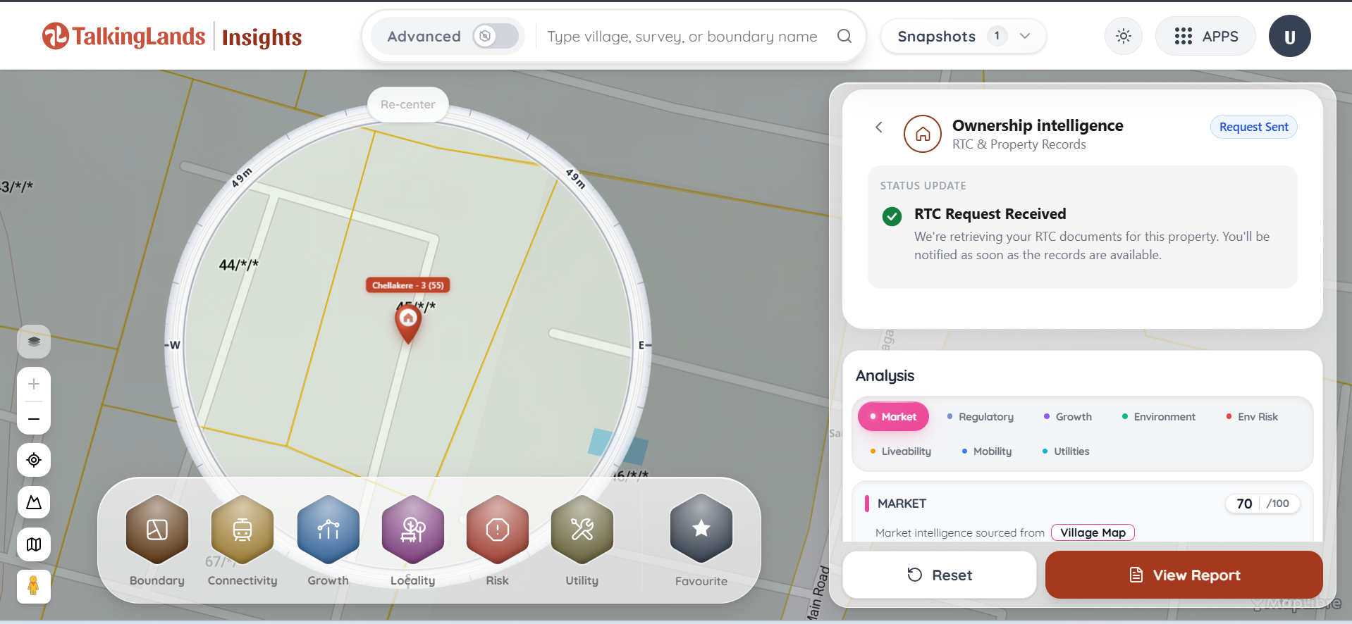
Quick Answer: To check your RTC (Pahani) online, visit the official Bhoomi portal (landrecords.karnataka.gov.in) and select "View RTC and MR." You must enter the property's District, Taluk, Hobli, Village, and Survey Number. For a faster, comprehensive check, use TalkingLands Ownership Intelligence to instantly view owner holdings, ULPIN, mutation status, court cases, and environmental spatial risks all in one unified dashboard.
What is the RTC (Pahani)?
In Karnataka, the RTC (Record of Rights, Tenancy and Crops) is the foundational land ownership record maintained by the state's Revenue Department.
If a piece of land is classified as agricultural, revenue land, or has not yet been officially converted for urban municipal use, the RTC acts as its birth certificate, identity card, and financial ledger all rolled into one. It records exactly who holds the rights to the dirt, what kind of dirt it is, and who has a financial claim over it.
Without a clean, updated RTC in the seller's name, you cannot legally buy the land, register a sale deed, or apply for a bank loan.
(To understand how the RTC fits into the broader legal picture alongside Khatas and Encumbrance Certificates, read our complete master guide on How to Check Who Owns a Property in Karnataka).
How to Read an RTC: What the Columns Show
To an untrained eye, a downloaded RTC looks like a confusing matrix of Kannada or English terms, numbers, and revenue codes. However, you only need to focus on a few critical sections to verify ownership safely.
Here is exactly what a standard Karnataka RTC shows:
- Khatedar (Landowner) Details: This lists the name of the absolute owner(s), their father's name, the specific owner category, and their respective share (if it is a joint family property).
- ULPIN: Modern digitized RTCs now frequently reference the Unique Land Parcel Identification Number (ULPIN)—a 14-digit alphanumeric "Aadhaar for Land" that prevents duplicate registrations.
- Survey Number & Hissa: The unique identifier for the land parcel (e.g., Survey No. 45). If the land was subdivided, it will show a Hissa (sub-division) number (e.g., 45/2). (Learn how to verify your survey number correctly).
- Land Extent & Classification: It details the total area in acres and guntas. It also classifies the land as agricultural, dry (Kushki), wet (Tari), or garden land (Bagayath).
- Mutation Reference: The MR (Mutation Register) number that proves how and when the current owner acquired the title (via sale, gift, or inheritance).
- Crop Details: A historical log of what crops have been cultivated on the land during specific seasons.
- Liabilities and Tenancy (Column 11): This is the most crucial section for buyers. If the owner has taken a tractor loan, crop loan, or mortgaged the land to a rural bank, it will be entered here. You cannot buy the land until these liabilities are cleared.
RTC vs. EC vs. Mutation: Understanding the Difference
Buyers frequently confuse the RTC with other property documents. Here is how they work together to form a complete title:
.png)
How to Check RTC Online (The Bhoomi Method)
You no longer have to stand in line at the Nadakacheri or Tahsildar’s office to verify basic land records. The Karnataka government’s Bhoomi Portal gives you digital access.
Follow these exact steps to check an RTC manually:
- Visit the Bhoomi Portal: Navigate to the official state land records website (
landrecords.karnataka.gov.in). - Access RTC Services: On the homepage, locate the "RTC Services" block and click on "View RTC and MR" (Mutation Register).
- Select the Geographic Path: The system requires you to drill down to the exact village level. Select your target property's District, then Taluk, then Hobli, and finally the Village from the drop-down menus.
- Enter the Survey Number: Input the primary Survey Number. If the plot has been divided, enter the Surnoc (Survey Number Character) and the Hissa (Sub-division number).
- Fetch the Record: Choose the period (current year or a past year) and click "Fetch Details." The system will generate a free, viewable version of the RTC instantly on your screen.
Note: If you need a legally valid, digitally signed copy to submit to a bank, you must use the "i-RTC" service, create a login, and pay a nominal statutory fee.
RTC vs. Khata: The Rural vs. Urban Rule
A massive point of confusion for buyers is asking a broker for an RTC on a city apartment, or demanding an A-Khata for a rural farm.
The Golden Rule:
- RTC (Pahani) is exclusively for Rural/Agricultural Land. It is maintained by the Revenue Department.
- Khata is exclusively for Urban/Converted Property. Once agricultural land undergoes DC Conversion and is approved for development by a planning authority, the RTC system is officially closed for that plot. Ownership tracking transfers to the local urban body, which issues a property tax Khata (like the e-Aasthi or e-Khata system).
If you are buying a site in an approved residential layout inside city limits, you should be verifying the Khata and the Sale Deed, not the RTC.
How to Verify Ownership Before Buying (Spotting Red Flags)
When looking at an RTC, keep a sharp eye out for these massive red flags:
- Name Mismatches: The name on the seller's Aadhaar card must perfectly match the Khatedar name on the live RTC. Watch out for missing middle initials or deceased parents still listed as owners.
- Joint Holdings (Multiple Khatedars): If the RTC lists four siblings as owners, and only one is offering to sell you the land, walk away. You need a registered partition deed or signatures from all co-owners to execute a valid sale.
- Active Liabilities (Column 11): If a cooperative bank holds a loan against the survey number, that debt is attached to the land, not the person. If you buy the land, you inherit the debt.
- Tenancy Entries: If someone other than the owner is listed as cultivating the land under tenancy laws, removing them legally is incredibly difficult.
The Faster Way: TalkingLands Ownership Intelligence
The Bhoomi portal is a functional tool for checking paper records, but jumping between Bhoomi for the RTC, Kaveri for the EC, and the e-Courts portal to check for litigation is tedious and exhausting.
More importantly, pure record-retrieval sites and basic government portals have a dangerous blind spot: they only tell you who owns the paper. They never tell you if the land is actually safe to build on.
TalkingLands Ownership Intelligence is different. We take you from owner verification to physical buildability in one single, unified report.
By simply entering your survey number into our platform, you instantly unlock:
- Live Owner Holdings (RTC Data): View the exact owner's name, father's name, ULPIN, land extent (acres/guntas), and owner category pulled directly from state databases.
- Mutation Status: Verify instantly if the title transfer has been officially recognized by the revenue department.
- Legal & Court-Case Check: We automatically scan the survey number for active litigation, delivering a clear "No court cases found" or flagging active disputes.
- Official RTC / Pahani Extract: Need the actual document? You can request the certified extract directly through the interface.
- Spatial Risk Integration: On the exact same screen, we map your verified survey number against master plan zoning. You instantly see if your cleanly-owned plot is secretly trapped inside a lake buffer, an Eco-Sensitive Zone, or a highway setback.
You no longer have to guess if a perfect title hides a geographic nightmare.
Frequently Asked Questions
1. How can I check my RTC (Pahani) online in Karnataka?
You can view your RTC for free on the official Karnataka Bhoomi portal (landrecords.karnataka.gov.in). Click on "View RTC and MR" and enter your district, taluk, hobli, village, and survey number. Alternatively, you can use TalkingLands Ownership Intelligence to view owner holdings and request the extract instantly.
2. What details are included in a Bhoomi RTC?
An RTC contains the absolute details of an agricultural land parcel. It lists the registered owner's name (Khatedar), father's name, the survey and hissa number, the ULPIN, the total land extent (in acres and guntas), soil and crop details, and any active liabilities, such as bank loans or court stays.
3. How do I download a digitally signed i-RTC?
While viewing the RTC is free on Bhoomi, if you need a legally valid copy for bank loans or property registration, you must use the "i-RTC" service on the Bhoomi homepage. It requires a simple login, mobile verification, and a nominal payment for the digitally signed copy.
4. Why doesn't my urban property have an RTC?
The RTC is maintained exclusively by the Revenue Department for agricultural, rural, and unconverted land. Once a property is legally converted (DC Conversion) and brought under urban municipal limits (like Bangalore's GBA/BBMP), the RTC is closed, and a Khata is issued to track ownership and property taxes.
5. What should I check in the RTC before buying land?
Always ensure the seller's name exactly matches the Khatedar name on the live digital RTC, not just a paper copy. Verify that the land extent matches the sale agreement, ensure there are no other joint-family owners listed, and check Column 11 for any uncleared bank loans.
6. Does a clean RTC mean I can build a house on the land?
No. An RTC only proves legal ownership and agricultural classification. To build a residential property, the land must undergo DC Conversion, and you must verify through spatial mapping that the survey number is not trapped inside a government green belt, lake buffer, or highway setback.
.png)

.png)


