.png)
What Is Dishaank? How to Use the Dishaank App to Find Survey-Number Boundaries in Karnataka (2026)
The Plot on the Map... But Is It Safe?
You are standing on a vacant parcel of land on the outskirts of Bangalore. The broker assures you it is Survey Number 45, it is two acres in size, and it is perfectly safe to buy. To verify, you pull out your smartphone, open the government’s Dishaank app, and let your GPS location load.
A digital polygon appears on the satellite map. The app confirms it: you are indeed standing inside Survey Number 45.
You feel a sense of relief. The government app validated the broker's claim. You go ahead and pay the advance to secure the land. But weeks later, your building plan is rejected. Why? Because while Dishaank successfully showed you the boundary of the land, it did not show you that a highly restrictive Eco-Sensitive Zone (ESZ) cuts right through the middle of the polygon, rendering it completely unbuildable.
The Dishaank app is an incredible technological achievement by the Karnataka government, fundamentally changing how citizens identify land parcels. However, relying on it as your only due-diligence tool is a massive mistake.
Whether you are a farmer looking up an ancestral plot or a developer underwriting a new layout, here is the definitive 2026 guide on what the Dishaank app is, exactly how to use it, what critical data it hides, and how to verify your plot's complete legal and spatial reality.
Quick Answer: Dishaank is a free GIS mobile app by the Karnataka Revenue Department that overlays digitized village cadastral maps onto satellite imagery. Using your phone's GPS, it shows you the exact survey-number boundary of the land you are standing on. While excellent for locating physical boundaries, Dishaank does not show master-plan zoning, environmental buffers, or active court cases. For a complete check—combining the survey boundary with zoning, risk, and verified ownership—you must use a comprehensive spatial intelligence platform like TalkingLands.
What is the Dishaank App?
For decades, Karnataka’s land records existed purely on fragile paper maps (Village Maps) stored in dusty revenue offices. Finding your exact plot boundaries meant hiring a surveyor to physically measure the land using traditional chains and reference stones.
To modernize this, the Survey Settlement and Land Records (SSLR) department and the Karnataka State Remote Sensing Applications Centre (KSRSAC) digitized over 30,000 revenue village maps. They overlaid these cadastral maps onto a satellite base layer to create Dishaank.
Dishaank is essentially "Google Maps for Survey Numbers." It allows any citizen to stand anywhere in Karnataka, open the app, and instantly see the official survey boundaries of the land beneath their feet.
What Dishaank Shows
When working correctly, the Dishaank app is a powerful preliminary identification tool. It provides:
- GPS "Where Am I?" Location: It places a blue dot on your live location and identifies which survey number you are currently standing inside.
- Survey & Hissa Boundaries: It draws distinct polygons (usually in bright colors) outlining the primary survey number and its specific sub-divisions (Hissas).
- Village Map Overlays: It shows you how the specific parcel fits into the larger village map structure, including adjacent survey numbers and access roads.
- Base Map Toggles: You can switch between standard terrain maps and satellite imagery to compare the drawn government boundaries against physical ground realities like trees, fences, and roads.
How to Use the Dishaank App (Step-by-Step)
Using Dishaank is relatively straightforward, provided the government servers are active. Here is how to locate any land parcel in Karnataka:
1. Download and Install
Search for "Dishaank" (or "Dishaank KSRSAC") on the Google Play Store (Android) or Apple App Store (iOS).
2. Enable GPS Accuracy
For the app to work on the ground, your smartphone’s location services must be turned on and set to "High Accuracy." Open the app and grant the required location permissions.
3. Finding Your Current Location
If you are physically standing on the land:
- Skip the welcome screens to access the main map interface.
- Tap the "Current Location" (crosshair) icon.
- The map will zoom in, drop a blue dot on your location, and highlight the polygon of the survey number you are inside.
4. Manual Survey Number Search
If you are sitting at home and want to look up a plot remotely:
- Tap the Search (Magnifying Glass) icon.
- You must enter the exact geographic hierarchy. Select the District → Taluk → Hobli → Village from the drop-down menus.
- Enter the Survey Number. (If you don't know the exact number, you cannot use the manual search function).
- The map will automatically fly to the location and highlight the parcel boundaries.
(If you are unsure of how to find or read your survey details, read our complete guide on How to Verify a Survey Number in Bangalore).
What Dishaank Does NOT Show (The Limitation)
Dishaank is a boundary identification tool, not a complete due-diligence platform. Using it to clear a property for purchase leaves you exposed to massive legal and geographical risks.
Here is what Dishaank fails to show:
- Master Plan Zoning (CDP): Dishaank does not show you the Comprehensive Development Plan (CDP). The plot might have a clear boundary on Dishaank, but the local municipal authority may have zoned it as a permanent agricultural Green Belt where you cannot build a home.
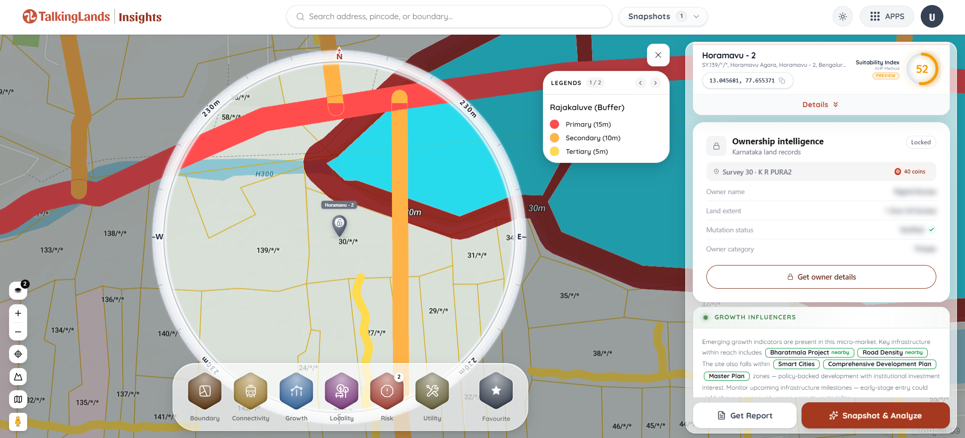
- Environmental Risk & Buffers: Dishaank will not highlight the invisible 75-meter NGT buffer around a nearby lake or a Rajakaluve (stormwater drain) cutting through the edge of your plot.
- Live, Seamless Ownership: While Dishaank has an "RTC" button, it simply redirects you to the external Bhoomi portal web browser. It frequently times out, and it does not alert you to active civil court cases or title disputes.
- App Stability Issues: In 2026, the Dishaank app remains notoriously buggy. Users frequently report "Network Connectivity Errors," infinite loading screens, and GPS offsets where the blue dot is misaligned with the actual physical ground by 10 to 20 feet.
Dishaank vs. TalkingLands: Getting the Full Picture
If you want to buy land safely, you need to combine the cadastral boundaries of Dishaank with advanced spatial and legal intelligence.
This is exactly what TalkingLands does. We take the same official survey-number boundaries you see on Dishaank and supercharge them with the missing layers of intelligence.
Furthermore, with the newly launched TalkingLands Ownership Intelligence, you don't have to suffer through Bhoomi server timeouts. For any survey number, you can instantly look up owner holdings (RTC), ULPIN, mutation status, and run a live check for active court cases—all inside the same spatial map.
Dishaank vs TalkingLands — What Each Shows
.png)
How to Fully Verify a Plot (The 4-Step Process)
Do not pay a token advance until you have run this complete 4-step check:
- The Boundary Check (Where is it?): Use Dishaank or TalkingLands to confirm the physical land on the ground matches the exact survey number in the seller's paperwork.
- The Ownership Check (Who owns it?): Use TalkingLands Ownership Intelligence to verify the seller’s name against live RTC holdings, ensure the mutation is complete, and verify there are zero active court cases.
- The Zoning Check (Can you build?): Overlay the local municipal master plan zoning to ensure the land is cleared for residential or commercial development.
- The Risk Check (Is it safe?): Scan the plot for hidden spatial risks like flood zones, high-tension power lines, and Eco-Sensitive Zone buffers.
Frequently Asked Questions
1. What is the Dishaank app?
Dishaank is a free mobile GIS application developed by the Survey Settlement and Land Records (SSLR) department of Karnataka. It allows users to view digitized village cadastral maps and identify exact survey-number boundaries over satellite imagery using their smartphone's GPS.
2. Can I use Dishaank on my PC or laptop?
There is no official native desktop or web version of the Dishaank app directly offered to the public by the government; it is primarily designed as an Android and iOS mobile app. To view survey boundaries and spatial data on a desktop web browser, users typically use platforms like TalkingLands.
3. Does Dishaank show land ownership details?
Dishaank provides an "RTC" button when you click on a survey polygon, but it does not display the data natively. Instead, it redirects you to the external Bhoomi portal website to fetch the Record of Rights, Tenancy, and Crops (RTC). For a seamless owner and court-case check, modern spatial platforms integrate this data directly.
4. Are the boundaries shown on Dishaank legally valid?
No. The SSLR department explicitly states that the boundaries shown on the Dishaank app are for informational and reference purposes only. They cannot be used as legal evidence in a court of law to settle property boundary disputes or encroachment claims.
5. Why is the Dishaank app not working or crashing?
Users frequently experience network connectivity errors or infinite loading screens on Dishaank due to heavy traffic on the government servers or outdated app versions. If the app fails to load, ensure your GPS is set to "High Accuracy," clear the app cache, or use alternative private GIS mapping tools to view the survey boundaries.
6. Can Dishaank tell me if my land is safe to build on?
No. Dishaank only shows the physical survey boundary. It does not display the municipal master plan zoning (CDP), nor does it highlight environmental risk zones like lake buffers, Rajakaluve drains, or highway setbacks. You must check these critical layers on a spatial intelligence platform before buying.
.png)

.png)


