
Property Report Bangalore (2026): How to Verify Any Plot or Project in Minutes
A Bangalore homebuyer finally finds what looks like the perfect property: a ready-to-move apartment in a quiet, high-demand residential pocket, priced just below the market average, with documents that the broker repeatedly insists are "one hundred percent clear." Reassured by the smooth pitch, the buyer transfers a token advance of ₹5 lakh to block the unit, without ever pulling a single property report Bangalore real estate experts rely on.
Three weeks later, when an independent advocate begins scrutinizing the file, the structural cracks emerge. The apartment complex is built on land carrying an unregularized B-Khata. Even worse, the underlying survey number sits on land demarcated as an agricultural green belt under the local master plan, meaning municipal building plan sanctions were never legally granted. To compound the disaster, an unresolved ancestral partition suit from 2014 remains active on the original survey number.
The deal unravels. The developer refuses to refund the token advance, litigation looms, and months of productive time are lost. None of this information was secret. Every single defect was recorded in state public registers, town planning maps, and revenue records. The problem was simple: the buyer lacked a unified, spatial mechanism to pull these fragmented threads together before signing the cheque.
That is precisely what a property report for a property in Bangalore delivers. Instead of spending weeks manually chasing half a dozen government offices, a consolidated property report unites cadastral boundary mapping, master plan zoning, Khata classifications, RERA filings, connectivity corridors, environmental buffers, and physical risk layers into a single, multi-page intelligence dossier. In a city where land records exist across disconnected state portals, having this unified view is the difference between making a confident, safe investment and entering a multi-year legal trap.
What is a Property Report — and Why Every Bangalore Buyer Needs One
Most property buyers equate due diligence with a standard "legal opinion" issued by a property advocate. While a legal opinion is indispensable for reviewing paper title deeds, it has an inherent blind spot: it rarely accounts for spatial geography.
An advocate reviews the sale deeds, encumbrance certificates, and tax receipts placed in front of them. However, paper documents cannot reveal whether a layout physically encroaches upon a primary storm water drain (Rajakaluve), whether a property sits inside a mandatory National Green Tribunal (NGT) lake buffer, or if the municipal master plan quietly rezoned the land for public infrastructure.
A modern property report is a consolidated spatial, legal, and environmental snapshot of a specific piece of real estate. It bridges the critical divide between paper title (who owns the asset on paper) and ground reality (what can legally and physically be built on that specific patch of earth).
Bangalore's rapid outward expansion over the past two decades has absorbed hundreds of rural revenue villages into the municipal fold. This urban sprawl created an administrative maze where property data is notoriously fragmented:
- Bhoomi Portal: Houses the RTC / Pahani & Revenue Mutation Extracts.
- Kaveri 2.0: Holds Encumbrance Certificates & Registered Deeds.
- BBMP / E-Aasthi: Manages Municipal Property Tax & Khata Registry.
- BDA / BMRDA / BIAAPA: Dictates Master Plan Zoning (CDP) & Layout Sanctions.
- Karnataka RERA: Tracks Project Approvals, Timelines & Litigation.
- KSRSAC / Revenue: Maps Lake Boundaries & Rajakaluve Cadastral Buffers.
Navigating this fragmented landscape independently requires searching half a dozen disconnected portals. A consolidated property verification report solves this structural inefficiency by pulling these statutory layers into one actionable assessment, allowing buyers to verify everything from the comfort of their screen.
What's Inside a TalkingLands Property Report (Page by Page)
A property report generated through TalkingLands Insights is structured to provide an exhaustive, multi-layered audit of any land parcel or residential development in Bengaluru. The report organizes complex spatial and legal datasets into distinct analytical sections:
Page 1: Property Summary & Spatial Analysis
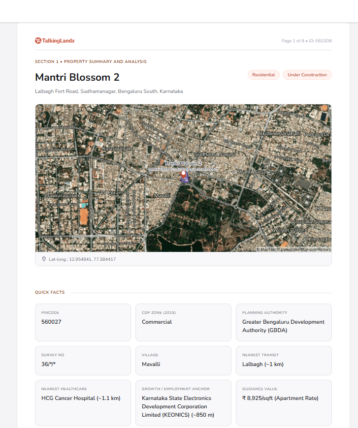
The report opens with high-resolution satellite imagery directly pinpointing the target parcel:
- Cadastral Geometry & Extent: Exact polygon coordinates (latitude and longitude) showing the true dimensions and perimeter of the land.
- Spatial Orientation: Visual demarcation of access roads, physical boundaries, and adjoining survey numbers.
- Geographical Context: Identification of the revenue village, hobli, taluk, and municipal ward enclosing the asset.
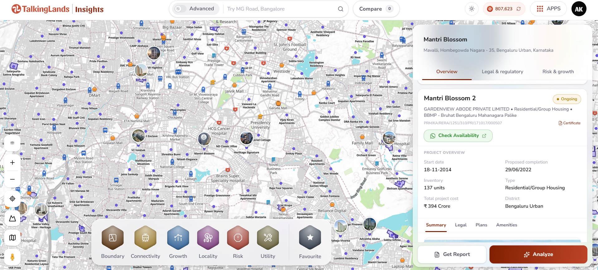
Search any Bangalore location, survey number or project — then click Get Report.
Page 2: Quick Facts Matrix
A standardized table capturing the critical regulatory and physical indicators:
- Master Plan (CDP) Zoning: The designated land use classification under the prevailing master plan (e.g., Residential Main, Residential Mixed, Commercial, Industrial, Public/Semi-Public, or Agricultural Green Belt).
- Planning Authority Jurisdiction: Identifies the governing planning agency legally authorized to sanction layouts or buildings on the site (e.g., BDA, BMRDA, BIAAPA, or DPA).
- Survey & Subdivision Reference: The exact revenue Survey Number, Hissa Number, or municipal plot identifier.
- Civic Infrastructure Proximity: Driving distance to the nearest operational or upcoming mass transit hubs (Namma Metro stations, suburban rail stations), healthcare networks, and primary educational institutions.
- Primary Growth & Employment Anchors: Proximity to major IT parks, industrial development corridors, and arterial expressways.
- Indicative Reference Valuation: A baseline reference rate reflecting localized values. (Note: This figure serves strictly as an indicative reference for preliminary sanity-checking; always verify the official guidance value determined by the Sub-Registrar Office or certified on the Kaveri portal).
Page 3: Legal, Regulatory & Project Compliance
This section outlines statutory compliance, varying based on whether the search is for a raw land parcel or an organized apartment/villa project:
- RERA Scrutiny: Confirms whether the project holds a valid Karnataka RERA registration, alongside the registered completion date, promoter profile, total land area, sanctioned building inventory, and registered encumbrance disclosures.
- Planning & Layout Sanctions: Verification of planning approvals, checking whether the layout holds statutory BDA/BMRDA sanctions or represents an unapproved subdivision.
- Khata Context: Structural analysis of the municipal tax registry classification (differentiating between permanent A-Khata entitlements and revenue-derived B-Khata entries).
Page 4: The Six Core Spatial Risk & Growth Layers
The report systematically evaluates the property against six spatial intelligence datasets:
- Boundary Layers: Cadastral boundaries, village maps, and revenue survey outlines, ensuring physical boundary markers match government land records.
- Connectivity Layers: Proximity to operational and proposed transport corridors, including Namma Metro lines, the Bengaluru Suburban Rail Project (BSRP), the Satellite Town Ring Road (STRR), and major arterial highways.
- Growth Layers: Active government infrastructure corridors, industrial clusters, and planned economic development zones driving localized appreciation.
- Locality Layers: Neighborhood density metrics, social infrastructure distribution, and immediate civic conveniences.
- Risk Layers (Critical Environmental Buffers): Audits whether the parcel intersects with NGT Lake Buffer Zones (mandatory 75-meter buffer from lake boundaries), Rajakaluve (Storm Water Drain) Buffers, and gazetted infrastructure acquisition corridors.
- Utility Layers: Proximity to primary municipal supply lines, water infrastructure, and major electrical networks.
How to Generate a Property Report for Any Bangalore Property
Generating a comprehensive property report online through TalkingLands Insights is straightforward, whether evaluating an empty agricultural parcel, a plotted layout, or a high-rise apartment.
Scenario A: Verifying an Apartment or Commercial Project
- Search the Project Name: Enter the registered project name (e.g., a branded apartment project in Whitefield, Sarjapur, or North Bangalore) into the search bar on TalkingLands Insights.
- Inspect the Project Overview: The platform brings up the digital property card showing the developer's entity name, RERA registration number, project completion timelines, sanctioned unit count, and exact spatial footprint.
- Generate the Report: Click the Get Report button to compile a multi-page PDF document detailing the project's spatial buffers, surrounding master plan zoning, connectivity scores, and municipal risk flags.
Scenario B: Verifying a Raw Land Parcel or Plotted Development
- Locate the Land: Search using the specific revenue Village Name and Survey Number, or drop a pin directly on the cadastral map interface.
- Review the Spatial Layers: Visualize the boundary overlay to confirm the plot's shape, check the surrounding Comprehensive Development Plan (CDP) zoning colors, and evaluate proximity to mapped roads.
- Generate the Report: Click Get Report to instantly generate a formal verification dossier detailing the survey number's planning authority, zoning compliance, environmental risk buffers, and growth proximity metrics.
What a Property Report Shows You That a Brochure Won't
Marketing brochures and developer pitch decks are sales tools designed to highlight aesthetic amenities while minimizing regulatory, spatial, and environmental constraints. A verified property report provides objective, data-backed scrutiny.
Broker's Word vs. a Property Report
What to Check in Your Report Before You Buy
Once you generate your property verification report, review it methodically. Pay close attention to these five critical indicators:
1. Verify Master Plan Zoning vs. Intended Land Use
The first rule of real estate due diligence in Karnataka is simple: Zoning dictates legality.
Check the "Master Plan Zoning" layer in your report.
- If you are purchasing an apartment or residential plot, the zone must be classified as Residential Main or Residential Mixed.
- If the report shows the zoning as Agricultural / Green Belt, you cannot legally construct a home, regardless of whether the seller has paid local panchayat taxes. Building on green belt land without a formal conversion order and a sanctioned layout plan invites municipal demolition. Learn how to find the zoning of a property in India to interpret town planning maps accurately. (Note: Master plan designations reflect the applicable CDP—always verify current zoning with the authority).
2. Scrutinize the Khata Context (A-Khata vs. B-Khata)
In Bengaluru, a Khata is an administrative record used by municipal bodies (like the BBMP) to assess and collect property tax. It is not a document of ownership title, but it determines whether a building is legally sanctioned.
- A-Khata: Signifies that the property complies with all town planning regulations, holds a valid building plan approval, and has paid all statutory development betterment charges. An A-Khata property is eligible for nationalized bank home loans and official occupancy certificates.
- B-Khata: An entry in a temporary register maintained by the BBMP to collect property taxes from unauthorized, unapproved, or non-converted properties. A B-Khata property cannot secure legitimate building plan sanctions, is rejected by top-tier financial institutions for mortgages, and carries ongoing regularization risks. Understand the legal mechanics in our detailed breakdown of A Khata vs B Khata in Bengaluru.
3. Cross-Examine RERA Project Registration Details
If purchasing an under-construction apartment, villa, or plotted development, cross-check the project details against the official Karnataka RERA portal:
- Verify that the registered promoter name matches the entity executing the sale agreement.
- Compare the completion deadline promised by the sales team against the legally declared RERA completion date.
- Examine whether the promoter has declared ongoing bank mortgages or active civil litigation on the project land.
4. Audit Environmental Buffers & Acquisition Corridors
Environmental compliance has become one of the strictest enforcement priorities in Bengaluru. The BBMP and revenue authorities regularly execute demolition drives against buildings infringing on water bodies.
Check the "Risk Layers" section of your report for:
- The 75-Meter Lake Buffer: Under NGT guidelines, construction is generally restricted within 75 meters of the water-spread boundary of any recognized lake (as per applicable rules — verify the current buffer with the authority).
- Rajakaluve (Storm Water Drain) Clearances: Identifying primary (50m), secondary (35m), and tertiary (25m) storm water drain buffers where construction is strictly prohibited (as per applicable rules — verify the current buffer with the authority).
- Compulsory Acquisition Overlays: Check whether the survey number intersects with gazetted infrastructure rights-of-way, such as BDA Peripheral Ring Road (PRR) corridors, Satellite Town Ring Road (STRR) alignments, or K-RIDE suburban rail buffers.
5. Validate Title Chain and Ensure Independent Verification
While the property report surfaces critical spatial and compliance metrics, combine it with a complete paper title audit:
- Unbroken Chain of Title: Ensure registered sale deeds form an unbroken chain. Under the landmark Supreme Court ruling in Suraj Lamp, a General Power of Attorney (GPA) transfer does not confer ownership title; only a registered Sale Deed is legally valid. Review the comprehensive land due diligence checklist for India.
- Encumbrance Certificate (EC): Cross-verify transactions using digital registration portals like Karnataka Anywhere Registration and Kaveri 2.0 to ensure zero undisclosed mortgages.
- Understand the Indicative Reference Rate: The property report provides an indicative reference rate to help you baseline micro-market pricing. Frame this strictly as an indicative reference—verify the official guidance value at the sub-registrar / Kaveri.
The Bottom Line
A residential plot or apartment purchase in Bengaluru is often one of the largest financial commitments an individual or family will make. Relying on verbal broker assurances, glossy brochures, or a superficial review of tax receipts is a dangerous gamble in an urban market with complex zoning overlaps and strict environmental buffer enforcement.
The smart, disciplined approach is to verify the property's spatial and regulatory fundamentals before signing a contract or transferring an advance deposit. By pulling a consolidated property report on TalkingLands Insights, you immediately uncover the land's master plan zoning, confirm administrative Khata boundaries, validate RERA disclosures, and ensure your building does not infringe upon lake buffers or planned road-widening corridors. Verify your parcel down to the survey number, read the report thoroughly, and invest with complete confidence.

Frequently Asked Questions
1. What is a property report for a Bangalore property?
A property report for a Bangalore property is a unified, multi-page spatial and legal intelligence document. It consolidates a plot or project's master plan zoning (CDP), local planning authority (BDA, BMRDA, BIAAPA), revenue survey numbers, municipal Khata classification, and Karnataka RERA compliance, alongside critical spatial risk overlays like lake buffers, storm water drains (Rajakaluves), and infrastructure acquisition lines.
2. How do I get a property report in Bangalore?
To get a property report, visit TalkingLands Insights, search for your target project name, locality, or specific revenue survey number on the map, review the spatial layers on the digital property card, and click the Get Report button to download a comprehensive verification dossier.
3. What does a property report include?
A standard property report includes a Property Summary (satellite view, coordinates, extent), Quick Facts (master plan zoning, planning authority, survey/hissa details, transit, civic amenities), Regulatory Compliance (Karnataka RERA registration, promoter details, inventory, Khata classification), and Spatial Risk & Growth Layers (boundary accuracy, connectivity corridors, growth anchors, NGT lake buffers, Rajakaluve drain buffers, and acquisition corridors).
4. Why do I need a property report before buying?
You need a property report to uncover critical structural, spatial, and legal defects that do not appear on standard sales brochures or basic tax receipts. It protects your capital by identifying unapproved layouts, B-Khata classifications, agricultural green belt zoning mismatches, NGT lake buffer violations, and active infrastructure acquisition corridors before you pay a non-refundable token advance.
5. Can I get a property report for a RERA-registered project?
Yes. TalkingLands Insights allows you to generate a detailed property report for any RERA-registered apartment, villa, or plotted layout in Bengaluru. The report surfaces the official promoter entity, RERA registration number, declared completion timelines, sanctioned unit counts, and surrounding master plan zoning.
6. Is the property report only for Bangalore?
While TalkingLands provides spatial intelligence across multiple Indian growth markets, its deepest per-plot cadastral and revenue survey coverage is currently centered in Bengaluru. In Bengaluru, properties can be verified down to the specific survey number and parcel boundary level.
Sources & Legal Disclaimer
- Regulatory Data Sources: Master plan zoning classifications derived from the Bangalore Development Authority (BDA) Revised Master Plan (RMP) / Comprehensive Development Plan (CDP), BMRDA regional plans, and BIAAPA outlines. Land records, Pahani extracts, and mutation entries referenced via the Karnataka Revenue Department (Bhoomi portal). Registration and encumbrance frameworks referenced through the Department of Stamps and Registration (Kaveri 2.0 portal). Project disclosures sourced from the Karnataka Real Estate Regulatory Authority (K-RERA). Environmental buffer directives derived from the National Green Tribunal (NGT) and Bruhat Bengaluru Mahanagara Palike (BBMP) lake and storm water drain (SWD) management guidelines.
- Legal & Technical Disclaimer: The property report, spatial layers, and analysis provided above and generated through TalkingLands Insights are intended for informational, spatial awareness, and preliminary verification purposes only. The indicative reference rates shown are baseline reference metrics and must not be construed as official property valuations or binding guidance values; official guidance values must be certified by the Sub-Registrar Office. Master plan zoning reflects the applicable master plan published by the respective planning authority and is subject to statutory amendments. This guide and the resulting reports do not constitute formal legal, taxation, or architectural advice. Buyers must engage a qualified property advocate to examine original title deeds and execute physical site inspections before completing any real estate transaction.
.png)

.png)


