Hoskote Metro Proposal: Mapped Stations, Road Connectivity and What to Check
Explore the proposed KR Puram–Hoskote link alongside surrounding roads. This guide separates project reporting from what is visible in TalkingLands, then shows you which layers to use for location research.

The short answer
Reporting dated 5 October 2026 describes a proposed 16.3-km KR Puram–Hoskote Metro link with 11 planned stations and DPR work underway. These are reported proposal details, not confirmation of a running service, final station locations or a completion date. Read the October report.
What you can learn from the map
- See the proposed station markers visible in the Hoskote-area screenshot.
- Explore their relationship with NH-75 and surrounding roads.
- Check water-body, flood-indicator and planning layers separately where coverage is available.
- Distinguish the mapped proposal from existing transport and final official approvals.
What is proposed between KR Puram and Hoskote?
The October report describes a proposed elevated Metro link running along the NH-75 / Old Madras Road corridor from KR Puram towards Hoskote. It gives an indicative length of 16.3 km and 11 planned stations. Treat the dimensions, station count and design as reported proposal information until supported by the relevant approved documents. Source: Magicbricks, 5 October 2026.
Earlier reporting dated 3 February 2026 describes government approval of the extension and initiation of a feasibility and technical study. Approval to study or advance a proposal should not be equated with final construction sanction. Source: Asianet Newsable.
The practical question for a resident or property buyer is not just whether a line appears on a map. It is how a location connects today, where the proposed markers are shown, and which aspects still depend on project decisions.
Station markers visible in TalkingLands
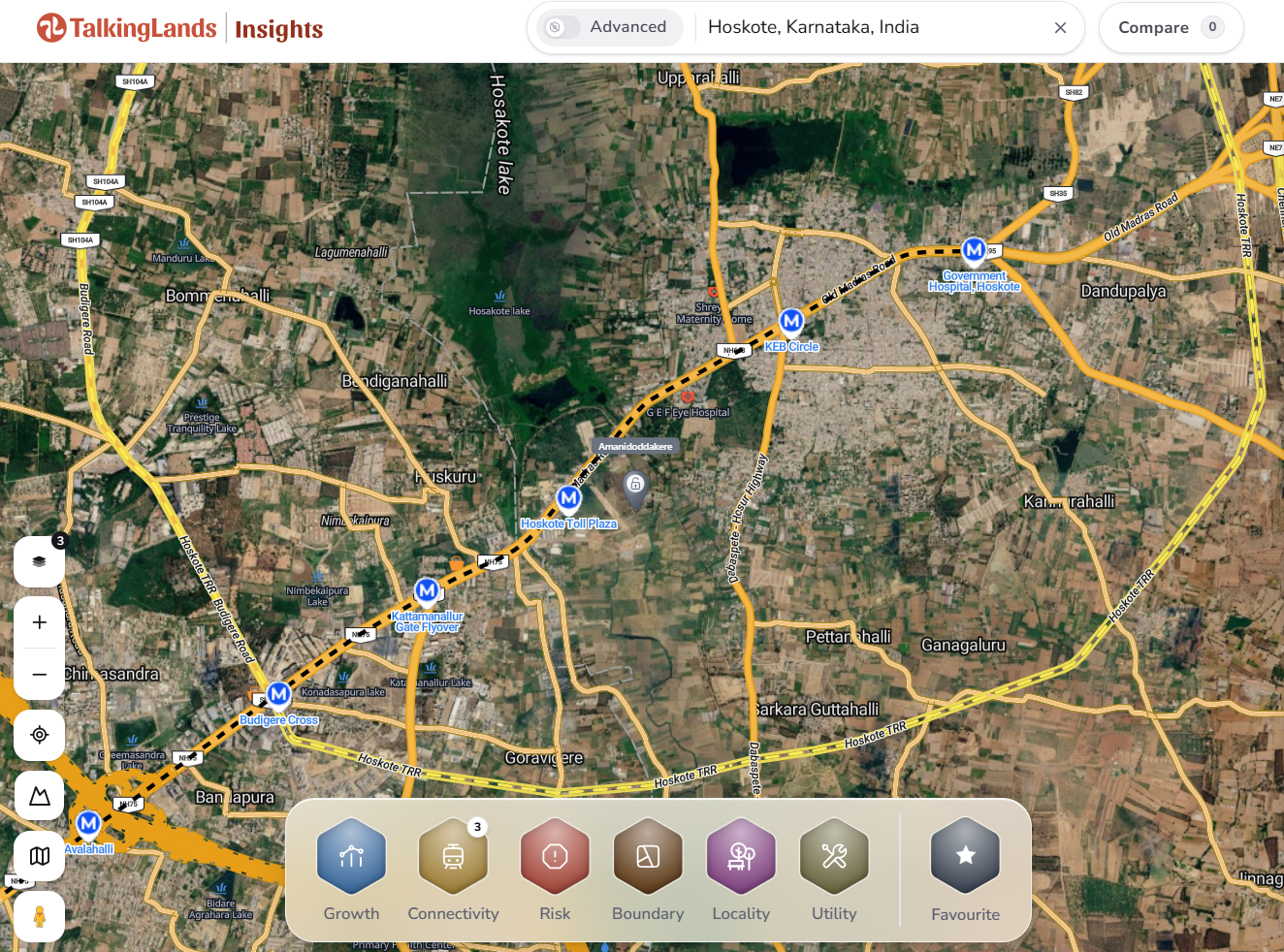
The screenshot below shows six named station markers on the Hoskote side of the mapped proposal. This is a partial view, not a verified list of all 11 planned stations. A marker identifies a mapped proposal location; it does not establish a final entrance, approved footprint or acquisition boundary.
| Marker label | What to inspect nearby | Evidence |
|---|---|---|
| Avalahalli | The western edge of this view and its road connections. | Visible map marker |
| Budigere Cross | NH-75, Budigere Road and surrounding junction access. | Visible map marker |
| Kattamanallur Gate Flyover | The road junction and available water-body mapping nearby. | Visible map marker |
| Hoskote Toll Plaza | Approach roads, crossing options and the actual route to a location. | Visible map marker |
| KEB Circle | Hoskote-town road connections and access constraints. | Visible map marker |
| Government Hospital, Hoskote | The eastern end of this view and surrounding local roads. | Visible map marker |
To research the KR Puram side, move the map west and inspect that section separately. A station not visible in this screenshot may still be available elsewhere in the application; this article does not classify it as missing.
Road connectivity: start with what serves the location
The Highway and Major Roads layers let you examine surrounding connections rather than relying on a proposed station alone. In this image, the labelled network includes Old Madras Road / NH-75, Budigere Road, the ring-road alignment labelled Hoskote TRR, and the Dabaspete–Hosur Highway.
A mapped road is a starting point for research. Check whether the relevant section is open, whether an interchange gives access, and whether the local approach is usable. A road passing close to a plot does not by itself establish a legal entrance or convenient access.
- NH-75: inspect the main corridor and the roads linking your location to it.
- Budigere Cross: examine the junction and crossing arrangements, rather than just proximity.
- Ring-road links: distinguish a labelled alignment from a verified operational connection.
- Existing Metro access: compare practical routes to existing stations. KR Puram is the reported proposal start, but the best current station depends on your location.
Which TalkingLands layers should you turn on?
Use separate views for separate questions. Start with the clean connectivity view, then add supporting layers only when they have coverage at the location.
1. Main view: transport connections
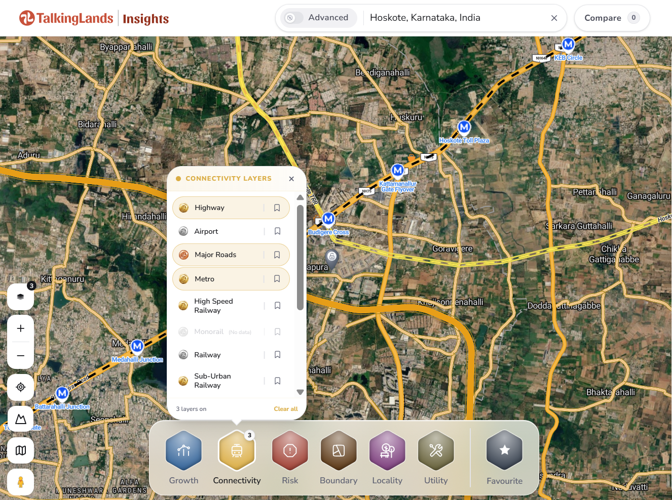
Connectivity → Metro + Highway + Major Roads. Inspect mapped station markers, the highway corridor and local approach roads. This is the combination used in the screenshot above.
2. Growth view: nearby activity
Growth → Industries, with Metro or Highway retained if useful. Explore mapped industrial locations. An industry marker is not evidence of a new announcement, employment forecast or guaranteed price growth.
3. Risk view: water and drainage context
Risk → Water Body + Flood Index; add Raja Kalva where available. These layers support screening. Water-body mapping is not a legal buffer determination, and a Flood Index is not live flood monitoring.
4. Planning view: jurisdiction and land use
Boundary → Master Plan + Planning Authority Maps; add Village Map where available. These establish planning and geographic context, not registered ownership or a legal parcel boundary.
Check a location in TalkingLands: step by step
- Search the area. Enter Hoskote, Karnataka, India, or search an identifiable locality or village.
- Open Connectivity. Turn on Metro, Highway and Major Roads.
- Locate your reference point. Use a known address, landmark or reliable coordinates. Confirm that it identifies the intended location, rather than a locality centre.
- Inspect proposed station markers. Note nearby labels and how roads connect to them. For walking or driving distances, use a suitable routing tool or field check; do not treat straight-line distance as travel distance.
- Check present-day access. Verify road status, entrances and crossings. Do not assume that a nearby highway provides direct access.
- Review Risk and Boundary. Select the available water-body, flood-indicator and planning layers. Keep the map readable by switching between focused views.
- Verify material facts. Check current BMRCL project records and applicable official planning documents. For a purchase, verify title, legal boundaries, approvals and encumbrances with qualified professionals.
What to verify before a property decision
Use the mapped proposal to frame questions, not to replace due diligence. Useful checks include:
- Has the latest official project stage changed since the cited reporting?
- Are station locations indicative, approved or revised?
- Does the location have usable and lawful road access today?
- Which planning authority and land-use provisions apply?
- Are there water-body, drainage or other constraints requiring official verification?
- Are claims about future station distance or completion dates supported by dated documents?
Infrastructure can change accessibility, but proximity alone does not establish future returns. Avoid treating a proposed Metro link as a guarantee of property appreciation.
Sources and evidence
- 3 February 2026 — Asianet Newsable: reported extension approval alongside a feasibility and technical study. Read the report.
- 5 October 2026 — Magicbricks: reported 16.3-km proposed link, 11 planned stations and DPR work underway. Read the report.
- TalkingLands Insights screenshot: visual evidence for the six markers listed in this article and the surrounding road labels. Open the full-size screenshot.
Project reporting and the map are different evidence types. Check current official BMRCL documents before relying on the final alignment, sanction or construction status.
See the connections around your location
Open TalkingLands Insights, search Hoskote, and explore Metro, Highway and Major Roads. Then review the available Risk and Boundary layers for more context.
Explore TalkingLands InsightsFrequently asked questions
Is there a metro to Hoskote right now?
No. The Hoskote link is a proposal, not an operating line. The October 2026 reporting cited in this guide describes a proposed KR Puram to Hoskote extension with detailed project report (DPR) work underway. Check BMRCL for any later change before treating it as sanctioned or funded.
How long is the proposed Hoskote Metro route and how many stations are planned?
Reports describe a proposed route of about 16.3 km between KR Puram and Hoskote with 11 planned stations. These are reported proposal figures. The alignment and station count can change when the DPR is finalised and approved.
Where are the proposed Hoskote Metro stations?
Reporting refers to 11 planned stations, but this guide lists only the six markers visible on the TalkingLands Insights map: Avalahalli, Budigere Cross, Kattamanallur Gate Flyover, Hoskote Toll Plaza, KEB Circle and Government Hospital, Hoskote. Treat all marker positions as indicative until BMRCL publishes a final station list.
When will the Hoskote Metro open?
No opening date is established by the sources cited here. A proposal at DPR stage still needs approvals, funding and construction before passenger service, so be cautious about any completion year quoted in a property listing or advertisement.
Will a metro station near my plot raise its price?
Not automatically. Proposed metro lines can influence demand, but price movement depends on whether the project is approved and built, the exact alignment, road access, the planning zone and the plot's legal status. Use the Connectivity, Growth and Risk views to check these factors, and treat any price claim as indicative.
How do I check whether my plot is near the proposed Hoskote Metro line?
Open TalkingLands Insights, search the village, survey number or area, and switch on Connectivity > Metro, Highway and Major Roads. Then zoom to your plot and compare its distance to the nearest marker. The steps are in the workflow section above.
Which TalkingLands layers should I check near Hoskote?
Start with Connectivity (Metro, Highway, Major Roads). Then add Growth > Industries, Risk > Water Body and Flood Index, and Boundary > Master Plan and Planning Authority Maps. Switch them on one at a time so each layer is easy to read.
Can the Boundary layers confirm who owns a plot?
No. Village, planning-authority and master-plan layers give geographic and planning context only. Legal ownership and exact property boundaries need authoritative records, such as the RTC, mutation records and a registered title chain, checked by a qualified professional.
What should I verify before buying land near the proposed metro?
Confirm the project's current status with BMRCL, check the plot's land-use zone and planning authority, look for lake, drain and flood exposure, verify title and the latest RTC, and confirm road access. Do not rely on a proposed metro marker as proof of future connectivity.
This guide provides general information, not legal, engineering or investment advice. Project details may change. Confirm material facts with BMRCL, the relevant authority and qualified professionals. Map coverage varies by location and layer.


