Chennai Metro Yellow Line (2026): Route, Stations, Map & Real Estate Impact
A complete guide to the Yellow Line (Corridor 4) — its route, every station, the opening timeline, and the localities along the corridor set to gain the most.
.png)
The Chennai Metro Yellow Line is Corridor 4 of Chennai Metro Phase 2, running about 26 km from Poonamallee in the west to Lighthouse on the coast, with around 30 stations. The elevated western stretch — from Poonamallee Bypass towards Vadapalani and Porur — reached roughly 95% completion and is targeted to open in 2026, giving fast-growing suburbs like Poonamallee, Iyyappanthangal and Porur direct rail access to the city for the first time. The underground section towards Lighthouse follows in a later phase.
Key takeaways
- The Yellow Line is Corridor 4 of Phase 2: Poonamallee ↔ Lighthouse, ~26 km, ~30 stations
- The elevated Poonamallee–Vadapalani/Porur stretch (~95% complete) is targeted to open in 2026
- The underground Vadapalani–Lighthouse section opens in a later phase
- Western suburbs — Poonamallee, Kumananchavadi, Iyyappanthangal, Porur — gain the most
- The line links with existing corridors around Vadapalani and the CMBT/Koyambedu belt
- Better connectivity typically lifts housing demand along the corridor
For years, getting from Poonamallee or Porur into central Chennai meant crawling along a choked arterial road for well over an hour. Every monsoon made it worse, and every new apartment block added to the traffic. The Chennai Metro Yellow Line is about to rewrite that daily reality — and, with it, the demand for land and homes right across the western corridor. As the elevated western stretch enters its final stages, here is everything a buyer or landowner needs to know: the route, the stations, the opening timeline, and the localities set to gain the most.
What is the Chennai Metro Yellow Line?
The Yellow Line is the popular name for Corridor 4 of Chennai Metro Phase 2 — the roughly 118 km, three-corridor expansion being built by Chennai Metro Rail Limited (CMRL). Phase 2 is one of the largest urban transit programmes underway in India, and it is designed to take the network deep into neighbourhoods that the first phase never reached.
Corridor 4 runs east–west across the city, connecting the western gateway town of Poonamallee to Lighthouse near the Marina, a distance of about 26 km. It is built as a mix of an elevated western section that runs above the suburban arterials and an underground central section that tunnels beneath the dense city core. The other Phase 2 corridors intersect the Yellow Line at key points, so the value of Corridor 4 is not just the line itself but the interchanges it creates.
Why was the west prioritised? Because that is where Chennai has been expanding fastest. Poonamallee, Porur and the belt around them have absorbed enormous residential and IT growth over the last decade, while road infrastructure has struggled to keep pace. A metro line is the single most effective way to unlock that congestion — and the demand that follows it.
Yellow Line route and station list
The Yellow Line runs from west to east, beginning at Poonamallee, threading through the suburban belt on an elevated viaduct, and then descending underground as it approaches the city centre on its way to the coast. Key stations along the corridor include:
| Station | Locality | Status |
|---|---|---|
| Poonamallee Bypass | Poonamallee (west terminus) | Opening 2026 |
| Mullaithottam | Poonamallee Govt Hospital | Opening 2026 |
| Kumananchavadi | Kumananchavadi | Opening 2026 |
| Thelliyaragaram | Iyyappanthangal (west) | Opening 2026 |
| Iyyappanthangal | Iyyappanthangal | Opening 2026 |
| Porur Bypass | Porur | Opening 2026 |
| Valasaravakkam | Valasaravakkam | Under construction |
| Virugambakkam | Virugambakkam | Under construction |
| Vadapalani | Vadapalani (city interchange) | Under construction |
| Kodambakkam / T. Nagar | Central Chennai (underground) | Under construction |
| Lighthouse | Marina (east terminus) | Under construction |
The full corridor is planned with around 30 stations; the table above lists the major stops. Station names and sequence should be confirmed against the latest CMRL alignment before relying on them for a purchase decision.
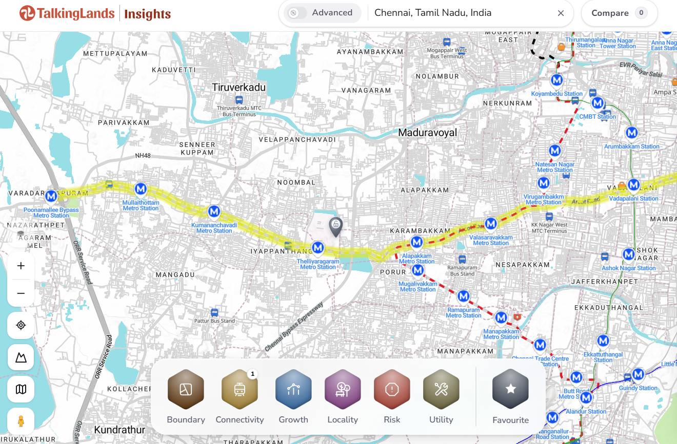
The Yellow Line runs west to east from Poonamallee, going underground as it nears the city core.
When will the Chennai Metro Yellow Line open?
The Yellow Line is opening in phases. The elevated western stretch — from Poonamallee Bypass towards Vadapalani and Porur — reached about 95% completion and cleared its major trial runs, with commercial operations targeted for 2026, subject to the mandatory Commissioner of Metro Rail Safety (CMRS) clearance. This is the segment that western commuters will feel first, and it is the reason the corridor is generating so much attention right now.
The underground section through the city core towards Lighthouse involves deeper tunnelling and more complex station work, and is expected to follow in a later phase. As with any metro project, exact dates can move with safety approvals and final testing — treat published timelines as the latest available position, not a guarantee. The direction of travel, however, is clear: the western corridor is nearly ready, and the rest of the line will follow.
Why the Yellow Line matters for the western suburbs
Connectivity is the single biggest driver of long-term property value, and the Yellow Line delivers it to a part of Chennai that has been starved of rapid transit. Today, a resident in Poonamallee or Iyyappanthangal relies almost entirely on buses and private vehicles to reach the city. Once the elevated stretch is live, that same commute becomes a predictable, air-conditioned metro ride — immune to monsoon flooding and peak-hour gridlock.
That shift does three things at once. It widens the pool of people willing to live in the western suburbs, because the commute is no longer a dealbreaker. It supports the IT and commercial clusters around Porur, making them easier to staff. And it tends to pull up both rental yields and land values within walking distance of stations. The pattern has played out along metro corridors in every major Indian city, and there is little reason to expect Chennai to behave differently.
Which Chennai localities benefit most from the Yellow Line?
The biggest winners are the western suburbs that, until now, had no rail link to the city:
- Poonamallee & Kumananchavadi: the western gateway, long dependent on a single congested arterial — now anchored by a metro terminus zone that will draw both residents and retail.
- Iyyappanthangal: a dense, established residential belt that suddenly gains direct city access, making it far more attractive to end-users and tenants.
- Porur: a major IT and residential hub where road congestion has been a chronic pain point; the metro is a genuine relief valve.
- Valasaravakkam & Virugambakkam: mature residential areas that gain a faster, more reliable route into central Chennai.
- Vadapalani: already well connected, it becomes an even stronger interchange node as the corridor links into the wider network.
That said, connectivity is only one factor. Two plots in the same locality can have very different prospects depending on zoning, approvals, road access and flood risk. A metro station nearby raises the ceiling on value — it does not guarantee it for every parcel.
What the Yellow Line means for real estate and land
For homebuyers, the practical takeaway is timing. Property near a confirmed, near-complete metro corridor tends to be priced ahead of the opening, but there is usually still a gap between "under construction" pricing and "fully operational" pricing. Buyers who do their diligence early — before every station is live — often capture part of that upside.
For landowners, the corridor changes the calculus on what to do with a holding. A parcel that was previously "too far out" can become a credible residential or mixed-use site once a station is within reach. But the same caution applies: the value is real only if the land use, title and approvals support development. It is worth checking the master-plan land use for your parcel and confirming there are no low-lying or water-body constraints before you count on a metro-driven premium.
How to check a plot before buying near a metro station
A metro line makes a location more attractive, but it does not make every plot along it a safe buy. Before you commit near a Yellow Line station, verify:
- Walking distance to the actual station — "metro connectivity" only helps if the station is genuinely close, not two kilometres away.
- Approved land use / zoning under the CMDA plan for that specific parcel.
- Road width and access to the plot, which affects both usability and resale.
- Low-lying / water-body risk — parts of Chennai are flood-prone, so check the terrain and drainage carefully.
- Clear title and encumbrance before parting with any advance.
Visualising the corridor and the neighbourhoods around each station on a map is the fastest way to sanity-check a location before you visit or negotiate — and to separate a genuinely well-placed plot from one that only looks close to the line on paper.
.png)
See the Yellow Line corridor on the map
Explore every Yellow Line station and the neighbourhoods around it on TalkingLands Insights — visualise the corridor and connectivity before you decide where to buy.
Explore on TalkingLands Insights →Frequently asked questions
The Chennai Metro Yellow Line is Corridor 4 of Chennai Metro Phase 2. It runs about 26 km from Poonamallee in the west to Lighthouse on the coast, with around 30 stations across an elevated western section and an underground city section.
The elevated western stretch from Poonamallee Bypass towards Vadapalani and Porur reached about 95% completion and is targeted to open in 2026, subject to CMRS safety clearance. The underground section towards Lighthouse follows in a later phase.
Corridor 4 is planned with around 30 stations, including a long elevated stretch along the Poonamallee–Vadapalani alignment plus underground stations through the city core. Exact counts can vary slightly by source as the underground section is finalised.
The line runs from Poonamallee in the west through Kumananchavadi, Iyyappanthangal, Porur, Valasaravakkam, Virugambakkam and Vadapalani, then continues underground through central Chennai towards Lighthouse near the Marina.
The fast-growing western suburbs gain the most — Poonamallee, Kumananchavadi, Iyyappanthangal, Porur, Valasaravakkam and Virugambakkam — which receive direct rail access to the city core for the first time.


