
Chennai Peripheral Ring Road (CPRR): Route, Phases & What It Means for Land Buyers
A 133 km outer ring road is being built to loop traffic around Chennai — from Ennore Port in the north to the Mamallapuram side in the south. Here is the route, the phase-by-phase status, and how to read the corridor before you invest.
.png)
The Chennai Peripheral Ring Road (CPRR) is a planned high-capacity outer ring road, roughly 133 km long, designed to connect Ennore Port in the north to the Mamallapuram (ECR) side in the south while bypassing the congested city core. By stitching together the northern port belt, the western industrial hubs of Sriperumbudur and Oragadam, and the southern IT corridor, it is set to reshape where Chennai grows next.
Key takeaways
- CPRR is a roughly 133 km outer ring road from Ennore Port to the Mamallapuram / ECR side, bypassing central Chennai.
- It is being built in five phases and links Thatchur, Sriperumbudur, Oragadam, Singaperumal Koil and Maraimalai Nagar.
- Progress is uneven — some stretches are largely built, others are still under construction or in land acquisition.
- It is implemented by Tamil Nadu road agencies (TNRIDC/TNRDC) with CMDA planning, part-funded by JICA.
- The strongest early beneficiaries are the Sriperumbudur–Oragadam belt and the southern Singaperumal Koil–Maraimalai Nagar nodes.
- Corridor benefit is local — proximity to an interchange and actual phase progress matter far more than the corridor name.
Every big city eventually hits the same wall: too much traffic funnelling through the middle. Chennai’s answer is the Peripheral Ring Road — a wide outer loop that lets port, freight and inter-city traffic skirt the city instead of crawling through it. For anyone watching land on Chennai’s edges, a corridor like this is one of the clearest signals of where the next decade of growth will concentrate. But “near the CPRR” is doing a lot of work in property ads right now, and the reality is far more location-specific.
What Is the Chennai Peripheral Ring Road?
The CPRR is a planned outer ring road of about 133 km, built to connect Ennore Port in the north to the Mamallapuram / East Coast Road side in the south, looping around the western edge of the metropolitan area. Its job is to move goods and long-distance traffic — especially port and industrial freight — without pushing it through the city, while opening up large tracts of the periphery for planned development.
It is being implemented by Tamil Nadu’s road infrastructure agencies (TNRIDC/TNRDC), with the CMDA handling planning and land acquisition, and part-funding from the Japan International Cooperation Agency (JICA). Because it is being delivered in phases, the corridor is not a single finished road today — it is a mix of completed, under-construction and still-being-acquired stretches.
CPRR Route and the Nodes It Connects
Broadly, the ring runs from the northern port belt down the western flank of the city and around to the south. Along the way it ties into several established growth nodes:
- Ennore / North Chennai — the port and logistics belt at the northern end.
- Thatchur & Tiruvallur side — the northern-to-western link, with plotted and affordable housing potential.
- Sriperumbudur & Oragadam — the established automobile, electronics and manufacturing heartland; the strongest current belt.
- Singaperumal Koil & Maraimalai Nagar — the southern industrial and residential nodes along GST Road.
- Mamallapuram / ECR side — the southern coastal end of the loop.
On a map, the value of the corridor is obvious: it connects the port, the airport catchment, the industrial west and the southern IT belt in one loop. But that value lands unevenly — a plot beside a planned interchange is a very different proposition from one several kilometres from the nearest access point.
CPRR Phases at a Glance
Here is the broad phase structure and indicative status. Treat all figures as indicative and subject to change — always verify the current notified alignment and progress before acting.
| Phase | Stretch (approx.) | Indicative status (2026) |
|---|---|---|
| Phase 1 | Ennore Port – Thatchur (~25.5 km) | Under construction; advanced in parts |
| Phase 2 | Thatchur – Pooncheri via Pattabiram (~26.3 km) | Some packages near complete; acquisition ongoing |
| Phase 3 | Pooncheri – Sriperumbudur (~30.0 km) | Slowest stretch; early construction |
| Phase 4 | Sriperumbudur – Singaperumal Koil (~27.0 km) | Main carriageway substantially built |
| Phase 5 | Singaperumal Koil – Mamallapuram (~24.2 km) | Early stage; targeted later (around 2030) |
The takeaway from the table is that CPRR is not one timeline but five. The Sriperumbudur–Singaperumal Koil side is far more advanced than the northern and far-southern phases, which is exactly why the western belt is seeing the most activity today.
.png)
The CPRR corridor traced on TalkingLands Insights — from the Ennore side down through Sriperumbudur, Oragadam and Maraimalai Nagar. Click to explore it live.
What CPRR Means for Land Buyers
A ring road changes land value through access — but the effect is concentrated, not uniform. Here is how to think about it:
- Proximity to an interchange is everything. Land value follows the entry/exit points, not the whole length of the road. A plot near a planned interchange benefits far more than one that the corridor merely passes by.
- Phase progress sets the timeline. On advanced stretches (Sriperumbudur–Singaperumal Koil), access is closer to real; on early phases, you are buying on a promise, so the risk and the wait are higher.
- Industry pulls housing. The Sriperumbudur–Oragadam manufacturing base and southern IT belt create the job density that makes nearby housing worth building — corridor plus employment is stronger than corridor alone.
- Alignment can shift. Until land is acquired and built, exact alignment and interchange locations can change — so a plot “on the CPRR” in a brochure may not be once the notified plan is final.
The honest summary: the CPRR is a real, large-scale catalyst, but the phrase “near the ring road” is only as good as the specific plot’s distance to an interchange and the phase’s actual progress. Both are things you can see on a map before you ever visit.
How to explore the corridor on TalkingLands Insights
Before you shortlist anything along the CPRR, it helps to see where a location actually sits relative to the corridor and what is around it. On TalkingLands Insights:
- 1. Search a town or location along the corridor — Sriperumbudur, Oragadam, Singaperumal Koil, and so on.
- 2. Open Connectivity → Highway to see the ring road and major roads around that location.
- 3. Add Growth and Locality layers to see what is developing nearby — industry, amenities and the wider node.
- 4. Check Boundary and Risk on any specific parcel before you take it further.
- 5. Verify the corridor alignment against the notified CMDA / TNRIDC plan and a property lawyer before you commit.
Coverage on the Chennai corridor is still growing, so treat Insights as a fast way to orient yourself and compare locations — then confirm the specifics against the official notified plan.
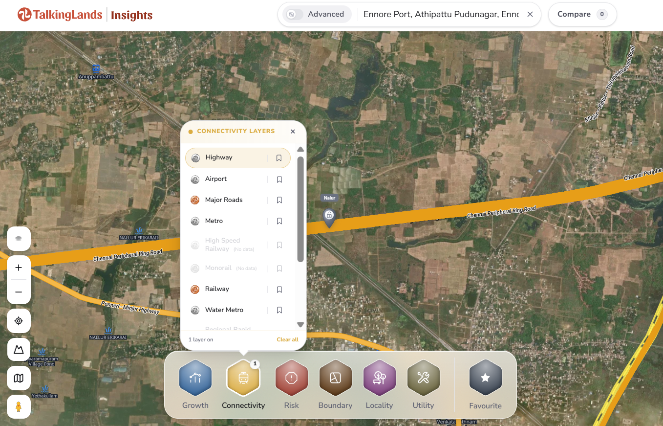
Connectivity layers on TalkingLands Insights — Highway switched on to trace the ring road and major roads near a location. Click to try it.
Common Mistakes Buyers Make Near a Ring Road
- Believing “on the CPRR” at face value — check the plot’s real distance to a planned interchange, not just that the corridor is nearby.
- Ignoring which phase it is — an early-stage stretch can be years from real access; match your timeline to the phase, not the map.
- Assuming the alignment is fixed — until land is acquired and built, alignment and access points can move; verify against the notified plan.
The Chennai Peripheral Ring Road is one of the most important things happening to the city’s edges — but it rewards buyers who read it as a map of interchanges and phases, not a single line on a brochure. Locate the plot, understand its phase, and verify the plan, and you turn corridor hype into a clear-eyed decision.
Explore the CPRR corridor on TalkingLands Insights
See the ring road, highways and growth nodes around any Chennai location — then dig into the parcels that interest you. Free to explore.
Explore the corridorFrequently asked questions
The CPRR is planned as an approximately 133 km outer ring road connecting Ennore Port in the north to the Mamallapuram (ECR) side in the south, bypassing central Chennai. It passes through nodes such as Thatchur, Sriperumbudur, Oragadam, Singaperumal Koil and Maraimalai Nagar, linking the northern port belt with the southern IT and industrial corridors.
Progress varies by phase. Some packages around Thatchur–Tiruvallur and the Sriperumbudur–Singaperumal Koil stretch are substantially built, while others — notably the Tiruvallur–Sriperumbudur stretch and the southern Singaperumal Koil–Mamallapuram phase — are still under construction or in land acquisition, with completion timelines running from 2027 to around 2030. Always check the latest notified status before acting.
The established western industrial belt around Sriperumbudur and Oragadam, the southern nodes of Singaperumal Koil and Maraimalai Nagar, the Tiruvallur side, and the northern Red Hills logistics belt are most often cited as gaining from the corridor. Benefit depends heavily on proximity to an interchange and the phase’s actual progress, so it varies plot to plot.
The corridor is being implemented by the Tamil Nadu road infrastructure agencies (TNRIDC/TNRDC) with CMDA handling planning and land acquisition, and is part-funded by JICA. Alignment, interchanges and land acquisition are defined by the notified plan, which is the record you should verify against.
On TalkingLands Insights, search a location along the corridor and turn on Connectivity to see the ring road and major roads, then add Growth and Locality layers to see what is developing nearby. It is a fast way to understand a plot’s position relative to the corridor before you verify the alignment against the notified CMDA/TNRIDC plan.
Disclaimer: This article is general information as of September 2026 and not legal or investment advice. CPRR alignment, phase status and timelines are indicative and change over time — verify the current notified plan with CMDA/TNRIDC and a qualified property lawyer before buying or building.


