Rajakaluve Buffer Zone Guidelines According to Bruhat Bengaluru Mahanagara Palike (BBMP) plays a pivotal role in regulating land use near rajakaluves buffer zone, Bengaluru's vital stormwater drains, to mitigate urban flooding and protect public safety. These rajakaluve buffer zone rules are legally enforced under the Revised Master Plan 2015 (RMP-2015) and National Green Tribunal (NGT) directives, mandating no-development zones around drains. Key regulations include setback distances by drain category, requiring No Objection Certificates (NOCs) for approvals, ensuring sustainable urban planning amid rapid city growth.
A Rajakaluve buffer zone refers to the restricted area around Bengaluru's stormwater drains, classified as primary (lake-to-lake/river flows), secondary (to lakes/primary drains), and tertiary (to secondary drains). Legally, under BBMP Rajakaluve buffer zone guidelines, this zone prohibits construction to preserve natural water flow, prevent encroachments, and reduce flood risks during monsoons. Standard distances, updated in the 2025 notification, include ~15m total for primary (7.5m each side from center), ~10m for secondary, and ~5m for tertiary Rajakaluves. These buffer zone for rajakaluve measures stem from NGT 2016 orders, later moderated by state plans, safeguarding ecology while allowing limited infrastructure like roads.
BBMP Rajakaluve buffer zone guidelines outline official setbacks measured from the drain's center line per revenue records, applicable across BBMP, BDA, and BMRDA jurisdictions. An NOC from BBMP's Storm Water Drains (SWD) division is mandatory for any layout or building plan near Rajakaluves, verifying compliance. Violations attract hefty fines starting at ₹5,000 per square meter, plus legal action under the Karnataka Municipal Corporations Act. Demolition risks loom for illegal structures, with BBMP conducting surveys and issuing notices, often leading to Supreme Court-backed removals. These rules align with RMP-2015, prioritizing flood prevention over unchecked development.
Before purchasing land in Bengaluru, verifying Rajakaluve buffer zone status is crucial to avoid BBMP Rajakaluve buffer zone pitfalls. Start by accessing official maps and records for accurate checks.
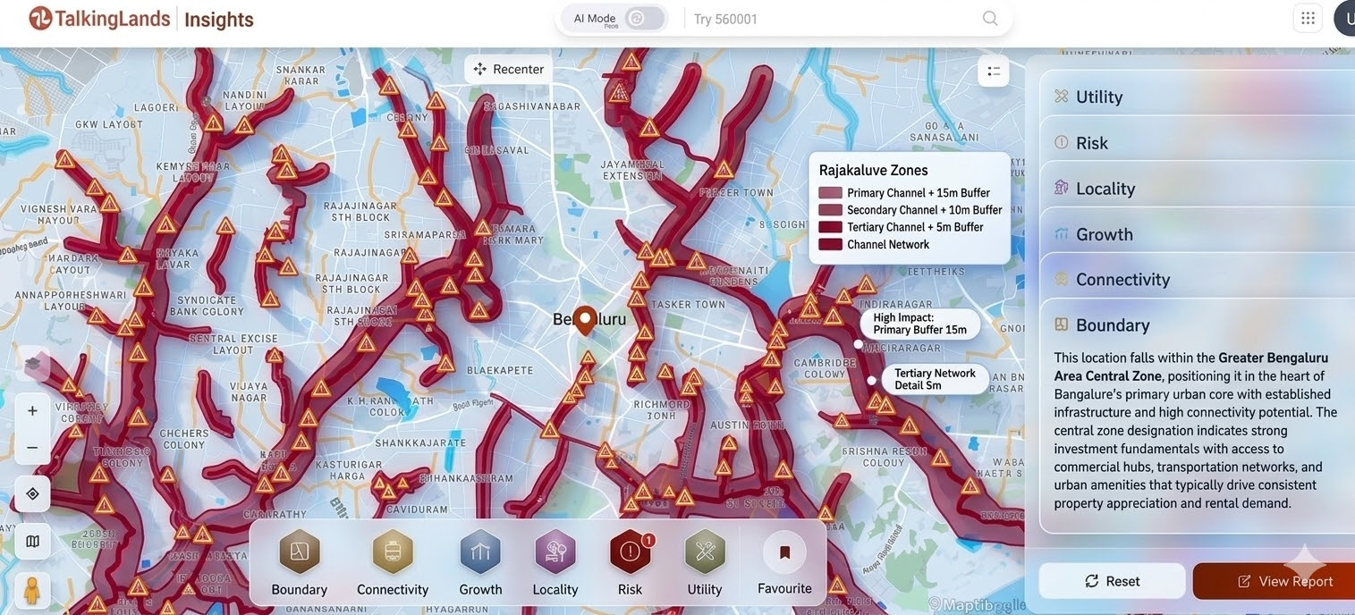
Step 1: Visit the Talking Lands portal and enter the survey number or property details to check Rajakaluve proximity and identify whether the land falls near a stormwater drain.
Step 2: Review the land insights available on the Talking Lands platform to understand the Rajakaluve classification (primary, secondary, or tertiary) and nearby drainage alignment.
Step 3: Use the digital map overlays on the Talking Lands portal to view the Rajakaluve buffer zone limits and assess potential restrictions before purchasing the property.
Step 4: Analyze the property report and supporting land data available on the platform, including layout details and surrounding infrastructure insights.
Step 5: If required, consult a local engineer or legal expert for a field verification to confirm there are no encroachments and that the land complies with local regulations..
The 2025 Karnataka government notification standardized rajakaluve buffer zone distances under BBMP oversight, reducing them from NGT 2016 levels for balanced development. Measurements are from the drain center, with no permanent structures allowed.
Ignoring buffer zone for Rajakaluve rules invites severe repercussions from BBMP Rajakaluve buffer zone enforcement, as seen in ongoing NGT-monitored drives. Properties in violation face immediate halts, financial losses, and legal battles, undermining investments.
- Heavy fines (₹5,000–₹50,000/sq.m) plus daily penalties until compliance.
- Compulsory demolition by BBMP bulldozers, with owners bearing costs.
- Criminal cases under IPC sections for public nuisance/flooding endangerment.
Access to green belts/parks in permitted zones, enhancing livability.
Legal peace of mind; avoids NGT/BBMP litigation costs.
Supports urban planning, qualifying for incentives like TDR (Transferable Development Rights).

Q1. What is the buffer distance for a primary Rajakaluve?
Approximately 25m total (~12.5m each side from center), per 2025 notification.
Q2. Can construction be done within the Rajakaluve buffer zone?
No permanent buildings; only roads, drains, or green belts with BBMP NOC.
Q3. How can I check if my property falls under a Rajakaluve buffer zone?
Use BBMP portal, RTC records, or GIS maps; apply for NOC/site inspection.
Q4. Does BBMP demolish illegal structures in buffer zones?
Yes, via surveys and notices; NGT enforces compliance.
Q5. Is bank loan approval affected if land is in a buffer zone?
Yes, loans are denied or recalled for non-compliant sites.
Q6. Which authority regulates Rajakaluve buffer zones in Bengaluru?
Primarily BBMP's SWD division, with BDA/BMRDA for layouts.

.png)
.png)
.png)
