.png)
A buyer sees an online advertisement for dirt-cheap plots in the "Sathanur Integrated Township—the next Bidadi." Believing they are getting in on the ground floor of a massive, government-backed satellite town, they pay a premium.
Years later, they try to secure a building plan sanction to construct a home. That is when reality sets in. The buyer discovers that the government's integrated township for Sathanur never actually materialized. The land they bought still carries old agricultural constraints from a decade-long land-use freeze, and their "township plot" is merely an unconverted, unapproved gram-panchayat B-khata parcel carved out of a farmer's field by a private broker.
Because "Sathanur Township" was an official government proposal back in 2006 under the BMRDA, the name carries a lingering aura of legitimacy. Unscrupulous developers routinely exploit this name to sell private layouts to unwary buyers.
If you are looking at land along the Kanakapura Road corridor in 2026, you must separate the historical hype from the legal reality. Here is the unvarnished truth about the Sathanur Township, its current status, why it was left behind by active mega-projects like Bidadi (GBIT), and exactly what you must verify before paying for a plot here.
Quick Answer: Sathanur (located in Kanakapura taluk, Ramanagara district, on the NH-948 corridor) was one of five BMRDA satellite townships originally proposed in 2006. To prevent speculation, the government placed a "land-use freeze" on the area. While the government is actively developing the Bidadi corridor today under the new Greater Bangalore Development Authority (GBDA), Sathanur is not currently an active government integrated township project. Recently, the Cabinet allowed Change of Land Use (CLU) applications in Sathanur on a case-by-case basis. If you buy a plot here, it is a private layout—you must independently verify its DC Conversion, Green Belt zoning, and DTCP/BMRDA approval.
Sathanur is strategically located in the Kanakapura taluk of the Ramanagara district. It sits squarely on the Kanakapura Road / NH-948 corridor (the Bengaluru–Kollegal–Coimbatore highway).
To understand the legal mess surrounding Sathanur plots, you must understand what happened in 2006 and how the governing authorities have evolved.
The 2006 Proposal: To decongest Bengaluru, the Bangalore Metropolitan Region Development Authority (BMRDA) proposed five massive, self-sustaining integrated satellite townships: Bidadi, Ramanagaram, Sathanur, Solur, and Nandagudi. Each required thousands of acres.The Land-Use Freeze: To stop land speculators from buying up the areas before the government could acquire them, a blanket land-use freeze was placed over these regions. Landowners could not get DC Conversion (Change of Land Use) to build residential layouts or commercial buildings.The Stall: Due to political shifts and massive farmer protests over land acquisition, the mega-township project stalled for nearly two decades.
The 2026 Reality: Recently, the state government revived the satellite town initiative under the newly formed Greater Bangalore Development Authority (GBDA). However, they prioritized Bidadi—now known as the Greater Bengaluru Integrated Township (GBIT)—along with Solur and Nandagudi due to their immediate proximity to the Satellite Town Ring Road (STRR) and the Bengaluru-Chennai Expressway.
Sathanur was left off the active mega-development list. Acknowledging that the 2006 land-use freeze had unfairly locked local farmers out of developing their land for 15+ years, the State Cabinet recently relaxed the rules, allowing CLU (Change of Land Use) applications in the Sathanur region to be processed on a case-by-case basis.
Note: Government mega-project statuses are highly fluid. The table reflects reported administrative priorities as of early 2026.
(Read our complete guide to the Bidadi Smart City / GBIT Project to understand the active township model).
.png)
Even without a massive government-funded mega-city, the Sathanur and Kanakapura Road corridor remains highly attractive to private investors. The growth here is organic, driven by fundamental infrastructure:
Because the "township" label is abused, buying a plot here requires ruthless due diligence. Watch out for these catastrophic traps:
To safely buy in Sathanur, you must verify the spatial and legal status of the exact piece of dirt you are standing on.
You cannot tell if a layout is legally approved or sitting inside a Green Belt by looking at a broker's glossy PDF brochure.
With TalkingLands Insights, checking your Sathanur plot takes seconds.Drop the exact survey number into the platform to visualize the plot on a live satellite map. Activate the Zoning / Land-Use Layer to instantly see if the land is legally zoned for residential development or trapped in an agricultural zone. Check the layout boundaries, measure distances to the NH-948 highway, and view critical spatial risks all on one screen.
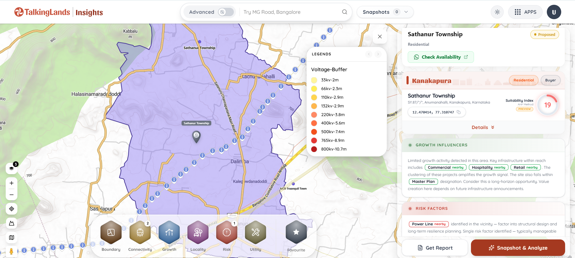
Sathanur is located in the Kanakapura taluk of the Ramanagara district. It sits along the Kanakapura Road (National Highway 948) corridor, south of Bengaluru, positioned past the Harohalli industrial belt.
No. While Sathanur was officially proposed as one of five BMRDA integrated satellite townships in 2006, the mega-project stalled. As of 2026, the government's active integrated township projects are focused primarily on Bidadi (GBIT), Solur, and Nandagudi under the new Greater Bangalore Development Authority (GBDA). "Sathanur Township" plots advertised today are generally private, independent layouts utilizing the historical name.
When the government proposed the satellite townships in 2006, it placed a freeze on land transactions and conversions in those areas to prevent speculation. Recently, recognizing that Sathanur is not an immediate government priority, the State Cabinet relaxed this freeze, allowing landowners to apply for Change of Land Use (CLU) on a case-by-case basis.
Absolutely. All land in Sathanur is originally agricultural. To legally construct a residential layout or a home, the developer or owner must secure a formal Change of Land Use (DC Conversion) from the Deputy Commissioner, explicitly changing the status from agricultural to residential.
It is safe only if you conduct rigorous due diligence. You must ensure the plot is not an unapproved Gram Panchayat "B-Khata" parcel, that it does not sit inside a restricted Agricultural Green Belt, and that the layout has secured formal planning authority (BMRDA/DTCP) approval.
You must verify the exact Survey Number of the plot. By utilizing a spatial intelligence platform like TalkingLands Insights, you can overlay the plot’s boundaries against official zoning maps to instantly check if the land is legally zoned for residential development and free from ecological buffer restrictions.



.png)

.png)
