
A simple verification step can prevent years of stress and uncertainty.
Buying land in Bengaluru can feel like a smart long-term investment. But before you finalize a deal, one critical check often gets overlooked, Rajakaluve Buffer Zone Before Buying Land.
Rajakaluve are natural stormwater drains that connect lakes across the city. Over the years, many properties have been built near or over these drains, leading to legal complications, demolition notices, and financial losses. Proper verification ensures your investment remains safe and compliant.
Purchasing land without checking its proximity to a Rajakaluve can expose you to serious financial and legal risks. Government authorities strictly enforce buffer zone regulations to prevent flooding and encroachment. If your property falls within a restricted zone, you may face penalties or even demolition.
A simple verification step can prevent years of stress and uncertainty.
Start by checking whether the land is located near any lakes in Bengaluru. Rajakaluves are designed to connect lakes and allow excess rainwater to flow safely from one water body to another. If your property lies between two lakes, there is a higher possibility of a stormwater drain running nearby.
Look into historical maps to verify old water channels, as some drains may not be visibly active today but still legally exist. Physically inspect the site to understand the natural slope and drainage pattern, water typically flows along the natural gradient. Low-lying areas or visible concrete storm drains near the plot may indicate proximity to a Rajakaluve.
The Revised Master Plan (RMP) and zoning maps provide official planning details for different areas of the city. These documents clearly mark stormwater drains, buffer zones, and land-use categories.
By reviewing these maps, you can determine whether your land falls within a designated buffer zone or close to a primary or secondary drain. Zoning maps also reveal if the land is classified as residential, commercial, agricultural, or green belt. Cross-checking your property survey number with these records helps avoid future regulatory issues.
Always ensure that the property’s usage aligns with the zoning category before proceeding with the purchase.
An official survey sketch provides the exact measurements and boundaries of the property. A Tippani copy (village map extract) shows the broader land layout, including adjacent government land, drains, and public spaces.
By examining these documents, you can identify whether any portion of the land overlaps with a stormwater drain or government land. Ensure that the survey number matches all other legal documents.
If needed, consult a licensed surveyor to conduct a physical demarcation of the plot. This ensures that the on-ground boundaries align with official land records and reduces the risk of future disputes.
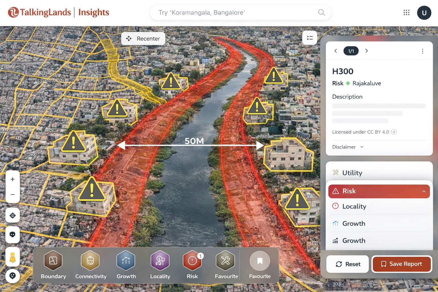
Modern tools make Rajakaluve verification easier. Platforms like the Talking Lands insights portal provide satellite-based mapping to analyze land parcels accurately.
You can overlay property boundaries on satellite imagery and check for nearby stormwater drains or water bodies. The tool helps assess the proximity of the land to natural drainage channels and identify potential risk zones.
Cross-verifying with satellite imagery allows you to visually confirm whether any visible drain runs close to or through the property. This digital layer of verification strengthens your due diligence process before finalizing the purchase.
Buffer distance rules vary depending on the type and width of the drain. Authorities mandate minimum setback distances from the edge of the Rajakaluve to prevent flooding and protect natural flow systems.
Typical buffer guidelines include:
Always verify the exact measurement from official authorities rather than relying on verbal assurances.
For complete clarity, visit the local zonal engineering office or municipal authority responsible for stormwater management. Submit your property details and request written clarification on buffer status.
Ask whether building plan approval is possible for the specific survey number. Written confirmation is essential, verbal assurances hold no legal value.
If the property is part of a larger development project, also check regulatory compliance under Karnataka RERA to ensure the project is legally registered and approved.
Preserve all correspondence and official documents carefully. These records provide legal protection if disputes arise later.
Beyond buffer verification, reviewing supporting legal documents ensures comprehensive due diligence.
Important documents to check:
Each document should clearly match the survey number and property dimensions. Any mismatch can signal legal complications. Thorough documentation review safeguards your ownership rights and prevents unexpected challenges after purchase.

While verifying Rajakaluve status, be alert to warning signs that may indicate hidden risks. Properties near drains are often marketed at attractive prices, but underlying legal issues may exist.
Watch out for:
If any of these signs appear, pause the transaction and conduct deeper verification. Acting early can save significant financial loss and legal trouble.
Q1. How do I know if my land is near a Rajakaluve?
Check zoning maps, survey sketches, satellite imagery, and physically inspect the area for visible stormwater drains or low-lying channels.
Q2. Can I build if land partially falls in buffer zone?
No permanent construction is typically allowed within the notified buffer zone. You may need to revise plans or avoid purchase.
Q3. Are buffer rules different for each drain type?
Yes, buffer distances vary depending on whether the drain is primary, secondary, or tertiary.
Q4. Can BBMP demolish buffer zone structures?
Yes, authorities can issue demolition notices for encroachments within designated buffer zones.
Q5. Do banks check buffer zone status before loan approval?
Yes, most banks conduct legal verification, and properties within restricted zones may face loan rejection.