The Peripheral Ring Road (PRR) in Bangalore, also known as Bengaluru Business Corridor (BBC), is a major infrastructure project aimed at easing traffic congestion beyond the Outer Ring Road (ORR). Developed by the Bangalore Development Authority (BDA), it promises enhanced connectivity and economic growth for the city.
Current roads have given way with Bangalore's rapid urbanization; like the ORR, which handles over 10,000 trucks daily as a de facto bypass. The Peripheral Ring Road Bangalore addresses this by creating an outer ring to divert interstate and long-distance traffic, reducing intra-city congestion and the urban heat island effect. Spanning north and east Bangalore, this 8-lane access-controlled expressway with service roads will integrate with NICE Road, forming a complete 116 km bypass around the city. Approved under a PPP-DBFOT model, it targets completion by late 2027, boosting logistics and real estate along its corridor.
The Bangalore peripheral ring road plan originates from BDA's vision to decongest ORR amid Bangalore's expansion beyond it, with the project notified in 2007 but revived in 2022 and rebranded as Bengaluru Business Corridor in 2024-2025. Estimated at Rs 27,000 crore, it features a 100m right-of-way (RoW), 8 main lanes (3.5m wide each), 6 service lanes, cycle tracks, and provisions for future metro. The government funds land acquisition, while the concessionaire handles construction, tolling for 50 years, and maintenance under PPP-DBFOT.
Get exclusive insights into how the Peripheral Ring Road is transforming connectivity, infrastructure, and real estate.
Objectives: Divert heavy vehicles from ORR, improve airport and highway connectivity, support future traffic growth up to 100 kmph design speed.
Scope: 73.5 km greenfield expressway closing the ring with NICE Road; includes cloverleaf junctions, flyovers, ROBs/RUBs, toll plazas, and green corridors.
Phasing: PRR-1 (current focus) covers 73 km; PRR-2 in DPR stage for southern/western parts.

The peripheral ring road Bangalore map shows a semi-circular alignment encircling north and east Bangalore, starting from Tumakuru Road (west) and ending at Hosur Road (east), complementing NICE Road's southern arc. Official BDA tender maps detail villages like Totadaguddahalli, Soladevanahalli, Yelahanka, Hennur, and Channasandra along the path.
Alignment: Counterclockwise from BIEC on Tumakuru Road (NH-4), via Hessaraghatta Road, Doddaballapur Road, Ballari Road, Hennur Road, Old Madras Road, Hoskote Road, Sarjapur Road to Hosur Road (NH-44).
Start-End Points: Begins at NICE Road junction near BIEC/Tumakuru Road; ends at Hosur Road junction with NICE Road near Electronics City.
Areas Covered: North (Yelahanka, Doddagubbi), East (Hoskote, Anekal), villages including Kogilu, Agrahara, Varthur, Gunjur.
Peripheral Ring Road Bangalore Length & Key Junctions
Measuring approximately 73.5 km, the PRR Bangalore length forms the missing link in Bangalore's outer bypass, with a 100m RoW narrowing to 65m built-up width (41m expressway + service roads). Key junctions include interchanges at major highways for seamless flow.
This setup ensures 100 kmph speeds with toll plazas at strategic points.
Discover what PRR really means for Bangalore’s future — visit Talking Lands for the full insights!
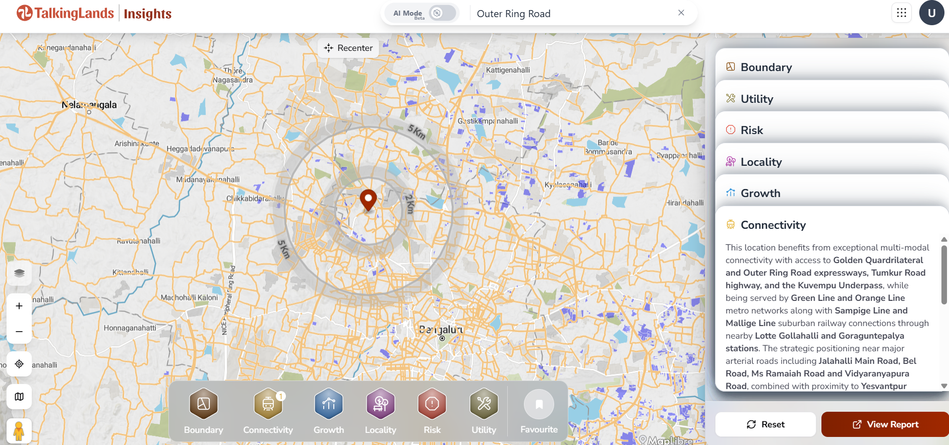
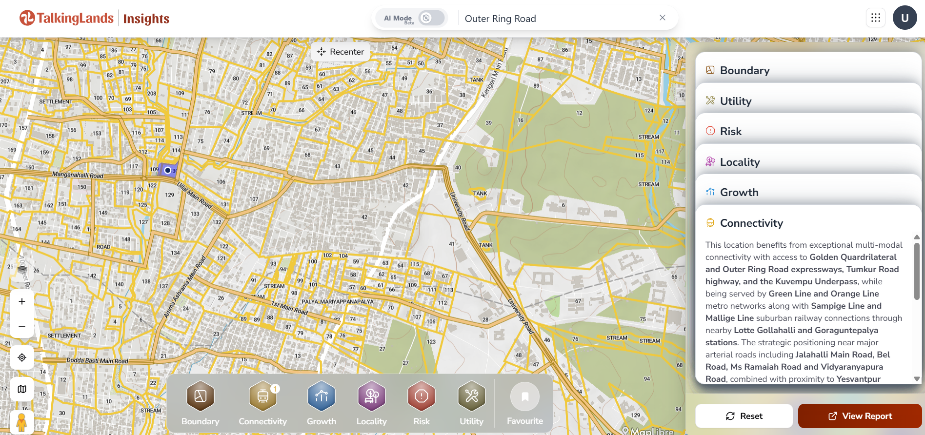
The new peripheral ring road Bangalore enhances Bangalore's role as a logistics hub by diverting trucks from ORR, potentially cutting peripheral traffic by 40%. It links key economic zones, easing inter-city movement and airport access.
- Traffic Relief: Diverts 10,000+ daily trucks from ORR, reducing congestion and heat island effects in central Bangalore.
- Logistics Boost: Direct connectivity to NH-4 (Tumakuru), NH-44 (Hosur), Ballari Road for freight to ports/airport.
- Inter-City Movement: Faster links to Tumakuru, Hoskote, Electronics City; service roads aid last-mile urban access with cycle tracks.
- Economic Ties: Integrates BIEC, IT parks in Whitefield/E-City, supporting business corridor vision.
- Peripheral Ring Road Bangalore Land Acquisition Status
Land acquisition for peripheral ring road Bangalore has been contentious, requiring ~2,560 acres across 1,036 hectares, with only minimal progress until recent cabinet approvals. In 2025, Karnataka empowered BDA for revised compensation on 948 acres (50% of needs), amid stalled talks with landowners. By early 2026, over 600 landowners consented, with options like 2-3x guidance value cash, TDR (twice land value), or enhanced FAR on remaining plots.
Challenges: Protests over denotification demands; prior notifications since 2007 yielded just 3.21 acres.
Progress: 2025 policy returns 35m of 100m RoW for commercial use; Rs 10,000 crore cost savings projected.
Current: Cabinet nod in Jan 2026 for higher payouts; first phase acquisition advancing for mid-2027 target.
As of February 2026, peripheral ring road Bangalore latest news highlights momentum with first-phase completion eyed for mid-2027, per Deputy CM DK Shivakumar. Tenders worth Rs 7,000 crore expected by March 2026 after prior cancellations. Renamed BBC, it integrates metro provisions and citizen centers for khata services.
Government Updates: Cabinet approved in Oct 2025 with new compensation; Shivakumar reviewed progress in Feb 2026.
Timelines: Phase 1 by mid-2027 (18 months from Feb 2026); full deadline Dec 2027.
Approvals: BDA empowered for 948 acres; no denotification, despite conservationist pushback.
The Peripheral Ring Road significantly impacts Bangalore real estate by unlocking peripheral lands for development, driving demand in underserved north-east corridors. Areas along the route see rising values due to improved access, with investors eyeing pre-completion buys for 20-30% appreciation post-ORR-like trends. Logistics parks, residential townships, and IT extensions are booming, though acquisition disputes cause short-term uncertainties.
Positive Drivers: Enhanced connectivity spurs commercial/residential growth; ORR saw 50% value hikes post-completion.
Challenges: Acquisition delays hit farmer sentiments; potential denotification risks in sensitive zones.
Investor Tips: Target villages like Yelahanka, Hennur for plots; diversify with TDR options; monitor BDA auctions.
The Peripheral Ring Road is vital for Bangalore’s sustainable expansion, alleviating ORR overload and fostering economic hubs in peripherals. By enhancing connectivity and land values, it positions investors for gains while curbing urban sprawl. With 2026-2027 milestones, timely action can capitalize on this transformative infrastructure.
1. What is Peripheral Ring Road Bangalore? - An 8-lane, 73.5 km expressway by BDA to bypass ORR, diverting heavy traffic and forming a 116 km ring with NICE Road.
2. What is the total length of PRR Bangalore? - Approximately 73.5 km for PRR-1; full ring ~116 km with NICE.
3. Which areas will PRR connect? - Tumakuru Road to Hosur Road via Ballari, Hennur, Old Madras Roads; covers Yelahanka, Hoskote, Electronics City fringes.
4. When will Peripheral Ring Road be completed? - First phase by mid-2027; full project targeted Dec 2027.
5. How will PRR reduce traffic congestion? - Diverts trucks/interstate vehicles from ORR, eases airport/highway flow, cuts peripheral traffic by up to 40%.
6. Is PRR good for real estate investment? - Yes, boosts values in north-east Bangalore; invest early in aligned areas for appreciation, but watch acquisition risks.