Bengaluru’s Nine Proposed Industrial Townships: What Land Buyers Should Check
Karnataka has announced a 10 to 15 year plan for the Bengaluru Metropolitan Region, built around nine integrated industrial townships, a new ring road, regional rail and a big water and housing push. Here is what was reported, what was not, and what land buyers should check.
.png)
The Bengaluru industrial townships are nine integrated industrial townships proposed across the Bengaluru Metropolitan Region as part of a 10 to 15 year development plan. Chief Minister D.K. Shivakumar spoke about the plan on 5 October 2026 after a review meeting, and it was widely reported on 6 October. About 13,500 acres have been identified for the townships, but the reporting does not name their locations or give approved footprints.
Key takeaways
- Nine integrated industrial townships are planned in the Bengaluru Metropolitan Region, with about 13,500 acres identified, of which about 7,900 acres are acquired and about 5,600 acres are being acquired.
- The locations of the nine townships were not specified, and no approved footprints have been reported.
- The plan proposes 6 to 6.5 lakh homes, including 40,000 to 50,000 for industrial workers.
- Transport proposals include 312 km of metro by 2037, a 210 km ring road linking 10 hubs, a 270 km regional rapid transit system and a possible high-speed rail extension to Mysuru.
- The region is projected to need 3,600 million litres of water a day by 2037, so water is a central part of the plan.
- Transport items were described as proposals under discussion, with no sanctions, funding or schedules reported.
Every few months a headline about Bengaluru industrial growth sends land buyers scrambling to the map. The latest is the plan for nine industrial townships across the Bengaluru Metropolitan Region. It sounds specific, and it is easy to turn it into a list of “best places to invest”. But the reporting does not name the township locations, and a list built on guesswork can cost a buyer real money. This guide sets out what the Bengaluru industrial township plan actually says, how it fits with the wider Bengaluru metropolitan region development plan, and what it does and does not tell you about land.
What was announced
As reported, Chief Minister D.K. Shivakumar spoke on Monday, 5 October 2026, at a meeting of the advisory group on the economic development plan for the Bengaluru Metropolitan Region. The plan was prepared with the ISEG Foundation, and news coverage followed on 6 October. It is described as a 10 to 15 year plan for the areas under the Bengaluru Metropolitan Region Development Authority, covering transport, housing, water and industry.
The headline targets are large. The state is reported to be aiming for an economy of 400 to 420 billion dollars by 2037 and one trillion dollars by 2047. To get there, the plan names five growth areas: technology, high-tech manufacturing, healthcare and education, infrastructure and sustainability, and planned urbanisation and housing. The industrial townships sit under the high-tech manufacturing and planned urbanisation parts of that framework.
Two further announcements got attention. The government wants an AI city modelled on Singapore’s Punggol, and an AI university, and officials were directed to identify land for both. Neither has a reported location yet. Bengaluru’s industrial growth story is therefore now being told at three scales at once: individual townships, regional transport links and city-level governance.
The nine townships: what is known
The core claim is simple: nine integrated industrial townships across the Bengaluru Metropolitan Region. An integrated township combines industrial land with housing, utilities, roads and services, so that jobs and homes are planned together. The reporting gives land figures but not a site list, and the table below separates what is reported from what is open.
| Question | What the reporting says | What is still open |
|---|---|---|
| How many townships? | Nine integrated industrial townships in the Bengaluru Metropolitan Region | Whether all nine will be notified, and in what order |
| Where are they? | Locations were not specified in the coverage we reviewed | Official township boundaries and survey numbers |
| How much land? | About 13,500 acres identified; about 7,900 acquired; about 5,600 being acquired | How the acreage splits across the nine sites |
| Housing? | 6 to 6.5 lakh homes, including 40,000 to 50,000 for industrial workers | Construction timeline and locations |
| Transport? | Metro, ring road, regional rapid transit and rail ideas under discussion | Approved alignments, funding and schedules |
| Timeline? | A 10 to 15 year plan, with 2037 and 2047 targets | Start dates for individual projects |
The land numbers deserve a second look. If about 7,900 acres are already acquired and about 5,600 more are under acquisition, then a large part of the land is already in government hands. That makes this different from a purely speculative announcement, but it also means the sites are likely to be tied to existing acquisition processes. Coverage also noted possible concern among farmers in Bidadi and nearby areas already in a land acquisition dispute with the state, which shows how sensitive the acquisition side of any township can be.
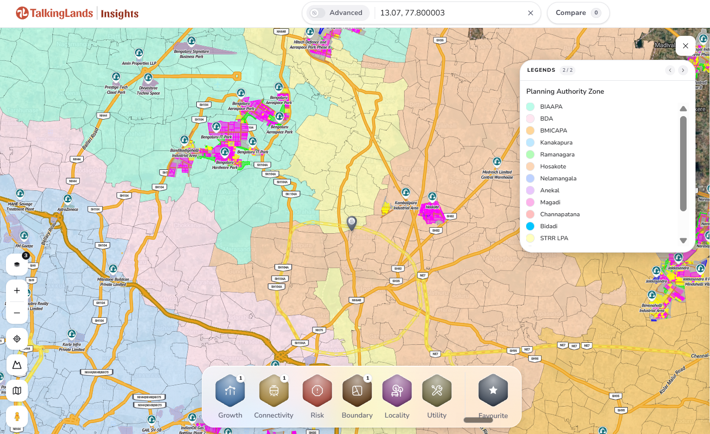
The Planning Authority Zone layer on TalkingLands Insights, with the legend listing authorities across the Bengaluru region. Tap to open the live map. Official township boundaries are not on it.
The transport corridors in the plan
Townships need access, and the plan pairs them with a set of regional transport proposals. These are the headline items as reported. All were described as proposals under discussion, and the coverage did not establish sanctions, funding or construction schedules.
- Metro expansion: 312 km of additional metro connectivity by 2037, alongside better suburban rail connectivity. One report mentions a 72 km suburban rail network.
- A 210 km ring road: a road linking 10 additional hubs around Bengaluru and connecting Phase 2 of the Peripheral Ring Road with NICE Road.
- Regional Rapid Transit System: a 270 km system linking Bengaluru with Tumakuru, Mysuru and Kolar Gold Fields.
- High-speed rail: a suggestion to extend the proposed Mumbai-Bengaluru high-speed rail corridor to Mysuru.
It helps to read these as a set. The ring road ties the outer hubs together, the regional rail lines run out along the Tumakuru, Mysuru and Kolar Gold Fields directions, and metro and suburban rail work on the inner side. Together they suggest an outer-ring and spoke pattern, which is why land buyers on the fringes of Bengaluru follow these announcements closely. At the same time, a proposed ring road without an approved alignment cannot tell you whether any particular village is on it. Many past proposals around Bengaluru have changed alignment between announcement and notification, so treat each item as a direction of travel, not a route on a map.
The ring road is also not the first of its kind in the conversation. Peripheral Ring Road Phase 2 and NICE Road are existing reference points in the plan, and the proposed 210 km road is described as linking them. That makes it a connector between known corridors rather than a wholly new idea, but its exact path is not public.
Housing, water and governance
The industrial townships are only one part of a package that also covers where people will live, where water will come from and who will govern it.
Housing. The plan proposes 6 to 6.5 lakh houses across the region, including 40,000 to 50,000 for industrial workers. No construction timeline was reported. The worker housing figure is a useful signal that the townships are meant to house their own workforce, but it also shows how small that share is against the total.
Water. The Bengaluru Metropolitan Region is projected to need 3,600 million litres of water a day by 2037. The government is to prepare a plan for drinking and industrial water, with priority on reusing treated water and rejuvenating lakes. Reports add that all of Bengaluru Urban district would be brought under the Bengaluru Water Supply and Sewerage Board in phases. For a land buyer, water is not a side issue: industrial clusters are big water users, and supply near a township is a fair question to ask.
Governance. Reporting says all areas of Bengaluru Urban district would come under the Greater Bengaluru Authority and urban local bodies, and that the full road network of the district would be mapped with a development plan prepared. These are administrative proposals. As one report put it, announced plans should not be read as completed infrastructure or notified jurisdiction changes.
What it could mean for land buyers
An announcement of this size will move conversations about land long before it moves anything on the ground. There are three sensible ways to think about it.
Direction, not destination. The plan tells you which way the region is being steered: more industry on the outer ring, more regional rail along the main highways, and more planned housing. It does not tell you which plot benefits. The 10 to 15 year horizon means any effect will be gradual, and short-term price claims deserve scepticism.
Inside or outside the boundary. Land inside a notified township boundary may be acquired or restricted. Land just outside may see rising interest. Since the boundaries are not public, a buyer cannot yet tell which side a plot sits on. That uncertainty is the single biggest reason not to buy on the headline. One thing you can already see is which planning authority covers an area, as the Planning Authority map earlier in this guide shows, and that decides which office and which master plan apply to a plot.
Jobs and services arrive later. Industrial employment can lift demand for rental homes and plots nearby, but demand follows jobs, not announcements. Townships that are proposed today may be years from operations, and infrastructure such as water and roads tends to arrive in phases.
Existing industrial areas on the map show the historical pattern: industrial parks, aerospace and logistics clusters have grown along highways with good access. That history helps you read a corridor, but it does not reveal where the nine new townships will be, and no existing industrial marker should be read as one of them.
What to verify before you buy
Whatever the final township map looks like, the checks for a plot near an industrial corridor stay the same:
- Status of the proposal: confirm whether a nearby township is proposed, notified or allotted, and ask for the official notification.
- Land acquisition: check whether the survey number is under acquisition or covered by a notification.
- Planning authority and zone: confirm which authority covers the plot and what zone the master plan assigns to it.
- Approvals: match the site to a sanctioned layout and confirm the land conversion order.
- Title and RTC: verify the RTC, mutation and a registered title chain with a property lawyer.
- Water, flood and access: check lake, drain and flood exposure, water supply and legal road access.
How to check on TalkingLands Insights
If a plot you are considering lies in an industrial corridor, three layers give you a quick first read of its surroundings:
- 1. Search the village or survey number on TalkingLands Insights.
- 2. Growth → Industries: turn on this layer to see tech parks, business parks, logistic parks and KIADB land nearby.
- 3. Connectivity → Highway: turn on this layer to see how the plot connects to highways.
- 4. Boundary → Planning Authority Maps: turn on this layer to see which planning authority the plot falls under.
- 5. Get Report: pull a property report, then confirm zone and approvals on the record.
These layers show existing context. They do not show the nine proposed townships, because official footprints have not been published.
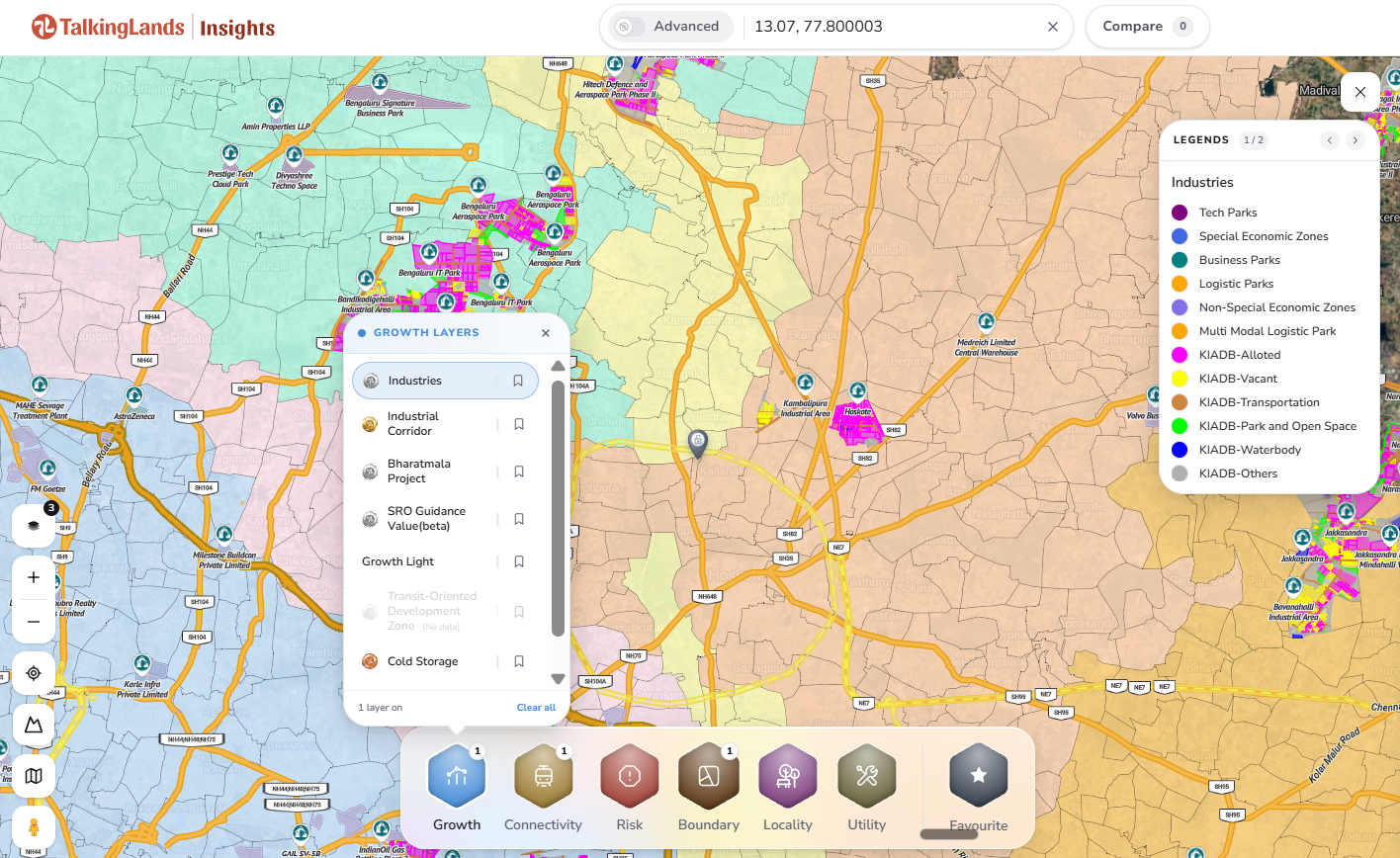
Open Growth, switch on Industries, then add Highway and Planning Authority Maps. Tap to open the live map.
Checking land near Bengaluru’s industrial belt?
See industries, highways, planning authority and risk layers for any plot on one map before you decide. Sign up free and get 5,000 coins.
Check Your Plot FreeFrequently asked questions
As reported after a 5 October 2026 review meeting on the Bengaluru Metropolitan Region economic development plan, the Karnataka government plans nine integrated industrial townships across the region, with about 13,500 acres identified. The locations of the nine townships were not specified in the reporting we reviewed, so treat any list of named sites with caution until an official notification appears.
Reports say about 13,500 acres are identified, of which roughly 7,900 acres have been acquired and acquisition of about 5,600 acres more is under way. These are reported figures from the announcement, not a parcel-level list.
The reporting does not name the locations. Until the government publishes township footprints, you cannot assume that any particular village or survey number falls inside one. Use the map to check a plot's context, not to claim it is part of a proposed township.
Not automatically. Price movement depends on whether the township is notified and built, the exact footprint, road and water access, the planning zone and the plot's legal status. Any price figure is indicative, and a proposal alone is not a guarantee of appreciation.
Search the village or survey number on TalkingLands Insights, then open Growth and switch on Industries, open Connectivity and switch on Highway, and open Boundary and switch on Planning Authority Maps. Then confirm the zone and approvals with the relevant authority.
It is a 10 to 15 year plan for the Bengaluru Metropolitan Region reported after the 5 October review, prepared with the ISEG Foundation. It covers technology, high-tech manufacturing, healthcare and education, infrastructure and sustainability, and planned urbanisation and housing. Transport items in it, such as metro, ring road and regional rail expansion, were described as proposals under discussion.
Disclaimer: This article is general information as of October 2026 and not legal or investment advice. It relies on media reports of a government announcement. Plans, locations, approvals, acquisitions and timelines may change, and map coverage varies by location and layer. Verify current information with the relevant authority and a qualified property lawyer before buying or booking.


