.png)
LAMS Software Explained: Land Acquisition Management Systems for Developers (2026)
The Spreadsheet Breakdown
Every year in India, top-tier real estate developers and infrastructure companies lose crores of rupees to bad land data and internal bottlenecks. Deals fall through because a hidden lake buffer wasn't flagged early, legal teams duplicate due-diligence efforts on rejected parcels, and acquisition pipelines tracked on scattered spreadsheets become hopelessly tangled.
For modern enterprises assembling 50-acre plotted layouts or acquiring contiguous land for industrial parks, managing land acquisition manually is no longer a viable business strategy. The solution scaling across India's top real estate developers, PE funds, and infrastructure firms is LAMS software (Land Acquisition Management System).
Whether you are an institutional fund evaluating commercial assets or a government parastatal managing highway acquisitions, here is the definitive 2026 guide to what LAMS software is, the core features you actually need, the true cost of manual acquisition, and how to choose the right platform.
Quick Answer: A Land Acquisition Management System (LAMS) is an end-to-end enterprise software platform that digitises the entire land-buying lifecycle. It centralises parcel identification, spatial due diligence, negotiation, legal documentation, and compensation tracking into a single dashboard, eliminating the financial and legal risks of manual spreadsheet management.
What Is LAMS Software?
At its core, LAMS software acts as the central nervous system for your enterprise land team. It is designed specifically to replace fragmented WhatsApp groups, static Excel trackers, and isolated physical files with a unified, spatially-aware digital pipeline.
A true LAMS platform tracks a land parcel from the very moment a broker pitches it, guiding it through preliminary spatial screening, intensive legal encumbrance checks, and financial negotiation, all the way to the final sale deed execution and mutation.
By maintaining a single source of truth, it ensures that your legal counsel, financial controllers, and on-ground acquisition managers are operating with the exact same real-time data. It prevents the all-too-common scenario where the finance team releases an advance payment for a plot that the legal team hasn't fully cleared for zoning compliance.
Why Manual Acquisition Fails
Relying on legacy methods to assemble multi-crore land parcels creates massive systemic vulnerabilities. When you manage land acquisition on spreadsheets, your process is inherently blind to geography.
- Missed Spatial Risks: Spreadsheets cannot overlay a survey number against a live Coastal Regulation Zone (CRZ) or a Rajakaluve (stormwater drain) buffer. You often discover zoning conflicts only after paying the non-refundable advance.
- Duplicated Effort: Without a central database, your legal team might spend weeks investigating the title history of a survey number that the acquisitions team already rejected six months ago.
- Data & Relationship Loss: When a key acquisition manager leaves the company, the historical context of local negotiations, family tree complexities, and broker relationships often leaves with them, forcing the enterprise to start from scratch.
Manual vs LAMS: The Cost Difference
The argument against adopting enterprise software usually revolves around the initial subscription cost. However, the true cost comparison must look at the financial leakage caused by manual processes. The ROI on a robust LAMS platform is often realized within the first avoided bad deal.
1. The Cost of Dead AdvancesIn manual workflows, spatial due diligence is often done sequentially after an initial token advance is paid to lock the land. If a physical surveyor later discovers that 40% of the plot falls under a protected Eco-Sensitive Zone (ESZ) or a proposed NHAI acquisition line, the deal is dead. Recovering that advance from landowners can take years of litigation. LAMS software shifts spatial screening to the very front of the funnel, catching these deal-breakers before a single rupee is transferred.
2. The Cost of Duplicate Legal Verification
Law firms charge significant fees for title search reports and Encumbrance Certificate (EC) verifications. In a large developer firm using spreadsheets, it is incredibly common for the same parcel (or adjacent parcels with the same root title) to be evaluated multiple times across different quarters by different acquisition managers. A LAMS platform logs every legal document against the specific polygon and survey number, creating a permanent, searchable archive that eliminates duplicate legal billing.
3. The Time-Value of Money (Holding Costs)
Land assembly for a 100-acre township requires negotiating with dozens of fragmented landowners. Manual tracking leads to stalled negotiations, missed follow-ups, and delayed compensation payouts. When a project's launch is delayed by 12 months because the land acquisition phase dragged on due to administrative chaos, the internal rate of return (IRR) on that capital drops significantly. LAMS accelerates the pipeline, turning capital into deployable assets faster.
%20(2).png)
Core Features to Look For (The LAMS Checklist)
Not all software marketed as LAMS is built the same. Many are simply repurposed CRMs that lack the spatial data required for real estate. When evaluating a platform, ensure it includes these non-negotiable features:
- Parcel-Level Mapping & Polygon Creation: The system must go beyond generic location pins. It needs to provide precise property polygons and cadastral boundary mapping so you know exactly where the property lines end.
- Duplication Detection Across Teams: A true enterprise system will automatically flag if a newly entered parcel overlaps or duplicates a parcel already evaluated by another team member.
- Comprehensive Deal Tracking: Customisable pipeline stages to track negotiation progress, financial disbursements, and document collection seamlessly.
- On-Map Utilities: Built-in capabilities to measure elevation, distance, and area, as well as the ability to attach media and notes directly to the map interface.
India-Specific Must-Haves: The Spatial Layer
Generic global real estate software fails in India because our land records, revenue systems, and regulatory frameworks are incredibly complex. A functional Indian LAMS must account for the reality on the ground by offering deep spatial intelligence overlays:
- Boundary & Zoning Data: Instant visibility into Village Maps, Comprehensive Development Plans (CDP), Ward Maps, and Planning Authority jurisdictions to ensure regulatory compliance.
- Connectivity & Growth Signals: Overlaying existing and upcoming infrastructure (Metro lines, High-Speed Railways, Industrial Corridors, and Bharatmala Projects) to gauge future appreciation potential.
- Environmental & Risk Buffers: Highly localised risk detection including Flood Indexes, Protected Area limits, Lake Buffers, and the critical Rajakaluve (stormwater drain) network.
- Pan-India Survey Data: The platform must possess a proprietary national survey number dataset, not just standard street addresses.
Who Uses LAMS?
The user base for institutional-grade Land Acquisition Management Systems is broad, encompassing any entity where land is a primary capital asset:
- Real Estate Developers: CEOs, MDs, and Procurement Heads use LAMS to manage massive land banks, evaluate joint ventures, and assemble multi-acre parcels for townships.
- Infrastructure Companies: Firms building airports, industrial parks, or data centers that require precise, contiguous land assembly across multiple jurisdictions.
- PE Funds & REITs: Investment vehicles and asset managers rely on LAMS for institutional-grade underwriting, compliance tracking, and managing the legal complexity of land portfolios.
- Government & Development Authorities: State bodies utilize the software to track large-scale public acquisitions and monitor development zones.
- Industries: Manufacturing, renewables, mining, and large-scale retail entities (malls, supermarkets) use it to scout and secure high-value commercial sites.
Where TalkingLands REALM Fits
If you are acquiring land in India, generic CRMs and globally-built real estate software will fundamentally bottleneck your growth. You need a platform built specifically for the complexities of the Indian market, running on a proprietary spatial data moat.
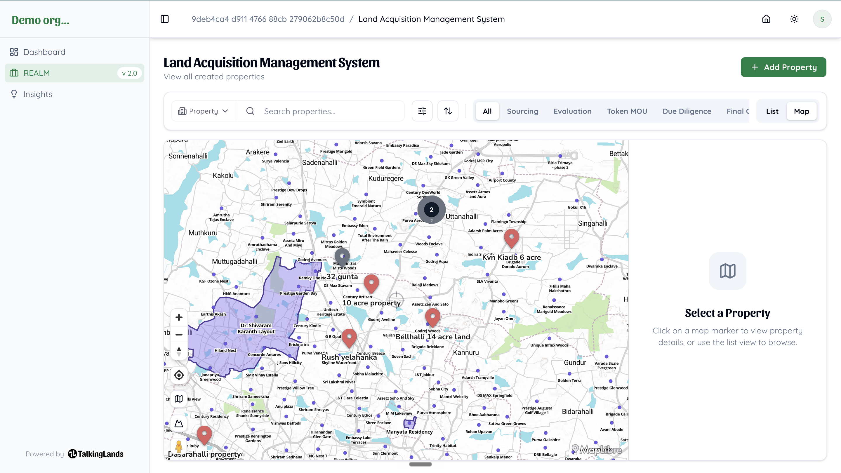
TalkingLands REALM is India's first end-to-end B2B land acquisition platform. It is engineered specifically for developers, PE funds, and enterprises, combining a dual architecture: robust Land Opportunity Management alongside Insights Spatial Intelligence.
REALM goes beyond basic pipeline tracking by offering over 40 interactive map layers—including precise Bangalore property polygons, pan-India survey datasets, and AI-powered Location & Property Reports. Instead of flying blind, your team can evaluate land backed by the same institutional-grade intelligence trusted by industry leaders like the Prestige Group and Hosachiguru.
With upcoming features on the roadmap including AI-powered Feasibility & ROI reports, digital delivery of EC/RTC documents, and deep Litigation Insights tied directly to survey numbers, REALM is the ultimate operating system for enterprise land acquisition.
Sources: Industry best practices, technological evaluations of enterprise land acquisition frameworks in the Indian real estate sector, and proprietary market data. Verified July 2026.
For a deeper dive into the specific compliance layers needed before buying, explore our guides on Land Acquisition Due Diligence and the Best Land Management Software in India.
-p-2000.png)
Frequently Asked Questions
1. What does LAMS stand for in real estate?
LAMS stands for Land Acquisition Management System. It is an enterprise software platform designed to digitise, track, and manage the entire lifecycle of acquiring land—from initial spatial identification and due diligence to final negotiation, legal registration, and compensation payout.
2. How is LAMS different from standard Land Management Software?
While standard Land Management Software usually focuses on managing properties after they are acquired (leasing, maintenance, tenant management, facility operations), LAMS is specifically built for the high-risk, complex workflow of acquiring the land. It deals with spatial screening, regulatory checks, boundary disputes, encumbrances, and owner negotiations.
3. Why is spatial intelligence crucial for a LAMS platform?
Without spatial intelligence, a LAMS is just a glorified spreadsheet or CRM. Integrating GIS data layers (like master-plan zoning, environmental buffers, and upcoming infrastructure) allows developers to visually and instantly disqualify unbuildable land before spending time and money on legal teams.
4. Who needs Land Acquisition Management Software?
It is essential for real estate developers, infrastructure firms, renewable energy companies, private equity funds, and government agencies that regularly assemble large or complex land parcels and need to manage the associated legal, spatial, and financial workflows at scale.
5. Can a LAMS platform prevent duplicate efforts in my team?
Yes. By acting as a single, centralised spatial database with built-in duplication detection, LAMS ensures that if your legal team rejects a survey number due to bad title history or a CRZ violation today, a new acquisition manager won't waste time evaluating the exact same parcel six months later. The history lives with the parcel polygon.
.png)

.png)


