NH-275 Mysuru–Madikeri Land Acquisition Notification 2026: What Landowners and Buyers Should Check
A Gazette notification dated 8 September 2026 lists 133 survey entries in 28 villages for the NH-275 Mysuru–Madikeri stretch. Here is what it says, which villages are covered, and how to check whether your land is on the schedule.

The NH 275 Mysuru Madikeri land acquisition notification is S.O. 4984(E), issued by the Ministry of Road Transport and Highways on 8 September 2026 under Section 3A(1) of the National Highways Act, 1956. It declares an intention to acquire specified private land along NH275 from Km 99.5 to Km 223.86 in Mysuru district. It is not proof that acquisition is complete, and being near the highway does not by itself mean a property is affected.
Key takeaways
- S.O. 4984(E), dated 8 September 2026, declares an intention to acquire land under Section 3A for NH275, Km 99.5 to Km 223.86 (Mysuru–Madikeri section).
- The schedule lists 133 entries covering 4.1158 hectares across 28 villages in Periyapatna, Hunsur and Mysuru taluks.
- Only the survey numbers in the schedule are covered. Being near NH-275 does not automatically mean a property is affected.
- The notification allows 21 days from Gazette publication to object under Section 3C(1), to be made to the competent authority, SLAO and CA Mysuru.
- Manchadevanahalli has the most entries (18), and Doddahosuru has the largest listed area (6,872 square metres).
- TalkingLands Insights shows highway and village context. It does not show the notified acquisition boundary.
When a highway notification lists survey numbers, the first question every owner and buyer asks is simple: is my land on it? This guide answers that for the NH 275 Mysuru Madikeri land acquisition, using the Gazette notification itself. We explain what the document says, which villages and survey numbers it lists, how to match your own land against the schedule, and what the notification does not tell you. The main message is worth stating up front: proximity to NH-275 does not mean a property is affected. A match on district, taluk, village and the complete survey number is what counts.
What does the NH 275 land acquisition notification say?
The notification is S.O. 4984(E), published by authority in the Gazette of India (Extraordinary) and dated 8 September 2026. It was issued by the Ministry of Road Transport and Highways. Using powers under sub-section (1) of Section 3A of the National Highways Act, 1956, the Central Government declares its intention to acquire land that it says is required for the public purpose of building, maintaining, managing and operating NH275.
The stated works are widening, two lane with paved shoulder, four laning and similar, on the stretch from Km 99.5 to Km 223.86, described as the Mysuru–Madikeri section, in Mysuru district of Karnataka. The reference number is NHAI/PIU-RMNG/14011/2018-19/NH-275/3A, and the notification is signed by Shaikh Aminkhan, Director.
Three points from the text matter most. First, this is a declaration of intention to acquire, not a statement that acquisition is complete. Second, any person interested in the land may object within 21 days from the date of publication in the Official Gazette, under Section 3C(1). Third, objections go in writing to the competent authority, named as SLAO & CA Mysuru, who must give the objector a chance to be heard and then decide, by order, whether to allow or disallow each objection. Any order made under Section 3C(2) is final. The copy we reviewed carries a digital signature dated 14 September 2026, so check the exact publication date and whether the objection window is still open with the competent authority.
Where is the listed land?
The schedule is organised by taluk and village, with a serial number, survey or plot number, type of land, nature of land and area for each entry. In total it lists 133 entries covering 4.1158 hectares (41,158 square metres), all of it private land. The villages fall in three taluks: nine village entries in Periyapatna, sixteen in Hunsur and three in Mysuru.
The individual entries are small. The average is about 309 square metres, and the largest single entry is survey number 65 in Thammadahalli at 2,630 square metres. That pattern is typical of strips taken for road widening, and it is another reason not to assume that a whole village, or a whole property near the road, is affected.
Most of the land is listed as agriculture. A handful of entries are listed as commercial (15 entries, all in Manchadevanahalli and Megalapura) and one as residential (survey number 2/2 in Manchadevanahalli). The table below shows every village entry in the schedule with its number of survey entries and total listed area. For the full list of survey numbers, use the Gazette schedule itself.
| Taluk | Village (as in the schedule) | Survey entries | Listed area (sq m) |
|---|---|---|---|
| Periyapatna | Doddahosuru | 10 | 6,872 |
| Periyapatna | Kandegala | 1 | 200 |
| Periyapatna | Mellahalli | 2 | 557 |
| Periyapatna | Kampalapura | 5 | 808 |
| Periyapatna | Borehosahalli | 11 | 2,468 |
| Periyapatna | Manchadevanahalli | 18 | 6,559 |
| Periyapatna | Kundanahalli | 1 | 1,500 |
| Periyapatna | Mallinathapura | 14 | 2,868 |
| Periyapatna | Harilapura | 3 | 2,020 |
| Hunsur | Belathuru | 1 | 150 |
| Hunsur | Kattemalalavadi | 1 | 145 |
| Hunsur | Agrahara | 1 | 170 |
| Hunsur | Undavadi | 2 | 170 |
| Hunsur | Hejjudlu | 7 | 1,828 |
| Hunsur | Krushnapura | 2 | 560 |
| Hunsur | Shiriyuru | 1 | 25 |
| Hunsur | Shiriyuru Nala | 2 | 325 |
| Hunsur | Kallahalli | 1 | 808 |
| Hunsur | Thammadahalli | 3 | 3,247 |
| Hunsur | Kirijaji | 2 | 170 |
| Hunsur | Kattemalalawadi Nala | 1 | 51 |
| Hunsur | Husenpura | 10 | 3,227 |
| Hunsur | Husenapurada Nala | 5 | 1,262 |
| Hunsur | Kempanahalli | 13 | 1,595 |
| Hunsur | Vaddarahalli | 3 | 1,737 |
| Mysuru | Yelachahalli | 1 | 175 |
| Mysuru | Megalapura | 9 | 1,133 |
| Mysuru | Ratnahalli | 3 | 528 |
Three of the Hunsur entries are listed as nala entries: Shiriyuru Nala, Kattemalalawadi Nala and Husenapurada Nala. They appear in the schedule as separate village headings, so look for them separately if your land is near a stream.
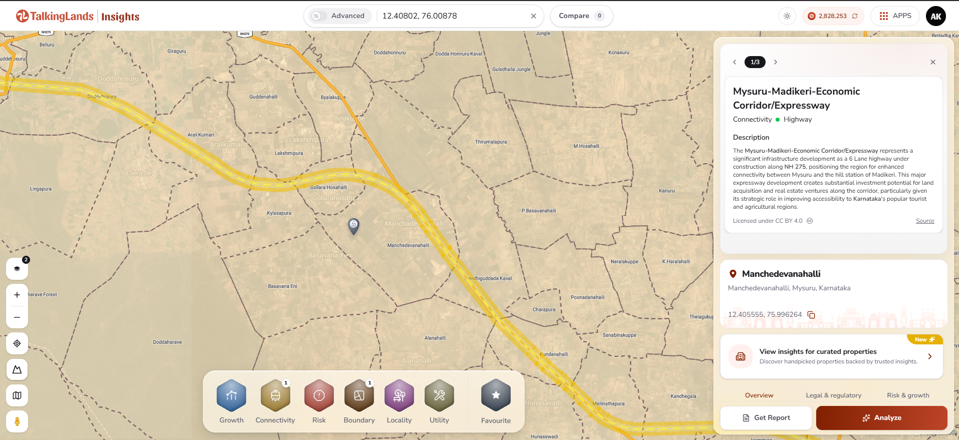
The Mysuru–Madikeri highway corridor near Manchadevanahalli on TalkingLands Insights, with the highway information panel. Tap to open the live map.
Manchadevanahalli: an example from the schedule
Manchadevanahalli, in Periyapatna taluk, has more entries than any other village in the schedule: 18 entries covering 6,559 square metres. The survey numbers listed are 1/3, 1/4, 11, 12/1, 12/2, 2/1, 2/2, 3/1, 3/2, 35/2, 35/3, 35/4, 35/5, 36, 6/1, 71/1, 71/4 and 8. Eight are listed as commercial, one as residential and the rest as agriculture. Note that the map shows the village spelled Manchedevanahalli, while the Gazette uses Manchadevanahalli. Spelling variants like this are common, so match on survey number as well as name.
Doddahosuru has the largest listed area at 6,872 square metres across 10 entries, followed by Manchadevanahalli.
How can you check your land against the notification?
Matching your land to the schedule is a careful, four-step job. Do it in this order:
- 1. Confirm the district, taluk and village. The schedule is for Mysuru district and lists Periyapatna, Hunsur and Mysuru taluks. If your land is in another taluk, it is not in this schedule.
- 2. Match the complete survey or subdivision number. A listing for 35/2 in Manchadevanahalli does not mean 35/6 is listed. Compare the whole number, including the part after the slash, with the RTC or sale deed.
- 3. Check the area listed in the schedule. The area is for the portion to be acquired, so it can be smaller than your whole parcel. Compare it with your parcel size.
- 4. Ask for the land plan. The notification says the land plans are available for inspection at the office of the competent authority. Use the plan, not a highway screenshot, to see the exact acquisition boundary.
If your land does appear in the schedule, you are the “person interested” the notification refers to. Contact the competent authority promptly about the objection process and your options, and consider speaking to a lawyer, because time limits apply.
What happens after a Section 3A notification
A Section 3A notification is the first formal step in a longer process under the National Highways Act. After objections under Section 3C are heard and decided, the Central Government can publish a declaration under Section 3D, and the compensation is determined under Section 3G. Those later steps are separate notifications. Until a later declaration is published, treat the 3A notification as a declared intention, and watch for any subsequent notifications covering your village.
This is general information, not legal advice. Timelines, compensation and rights depend on the details of the case, so confirm with the competent authority and a qualified lawyer.
What buyers and owners should verify next
If you are buying, selling or holding land near NH-275 in this stretch, the key point is simple: do not rely on highway proximity or a map screenshot. Verify these on the record:
- The schedule: check whether your village and the full survey number appear in S.O. 4984(E).
- Official land plans: ask the competent authority, SLAO and CA Mysuru, for the plan covering your survey number.
- Later notifications: look for any subsequent notification, including a declaration under Section 3D, covering your land.
- Title and RTC: verify the RTC, mutation records and the title chain with a property lawyer.
- The sale agreement: if you are buying, ask for written confirmation of whether any part of the parcel is affected, and what happens to the price if it is.
A plot beside a highway can be a good buy, but the right-of-way and any acquisition can reduce its usable area and change road access. That is a reason to ask the question before you pay, not a reason to panic.
How to check on TalkingLands Insights
TalkingLands Insights helps you see the highway and village context around a shortlisted location. It does not show the notified acquisition boundary, and the Notified Lands coverage is not currently available for this stretch. Use it for context, then use the Gazette schedule and the official plans for the notification itself.
- 1. Search the village, for example Manchadevanahalli, or its coordinates on TalkingLands Insights.
- 2. Connectivity → Highway: turn on this layer to see the NH275 corridor and the highway information panel.
- 3. Boundary → Village Map: turn on this layer to see the village boundaries around the location.
- 4. Get Report: pull a property report for the location, then match the survey number against the notification.
One caution: the highway panel on the map describes the corridor as a six-lane highway under construction, while the Gazette describes the purpose as widening, two lane with paved shoulder, four laning and similar. For what the acquisition covers, rely on the Gazette.
Open Connectivity, switch on Highway, then add the Village Map under Boundary. Tap to open the live map.
Understand the highway and village context around your land
Create a TalkingLands Insights account to explore the available layers for any shortlisted location. Sign up free and get 5,000 coins.
Check Your Plot FreeFrequently asked questions
S.O. 4984(E), dated 8 September 2026, is a Ministry of Road Transport and Highways notification under Section 3A(1) of the National Highways Act, 1956. It declares the Central Government's intention to acquire the listed land for building (widening, two lane with paved shoulder, four laning and similar), maintaining and operating NH275 from Km 99.5 to Km 223.86 in Mysuru district. It is a declaration of intention, not proof that acquisition is complete.
The schedule lists 28 village entries across three taluks: 9 in Periyapatna, 16 in Hunsur and 3 in Mysuru. Three of the Hunsur entries are listed as nala entries (Shiriyuru Nala, Kattemalalawadi Nala and Husenapurada Nala). The village table in this guide lists each one with its number of survey entries.
The schedule has 133 serial entries covering a total of 4.1158 hectares (41,158 square metres). Some survey numbers are subdivisions, so match the full number, including the part after the slash.
No. Only the survey numbers listed in the schedule are covered by this notification, and the listed areas are small parcels, with an average of about 309 square metres per entry. Match your district, taluk, village and complete survey number against the schedule, then confirm the exact boundary with the competent authority.
The notification allows 21 days from the date of publication in the Official Gazette to object under Section 3C(1). Objections go in writing to the competent authority, the SLAO and CA Mysuru. The copy we reviewed carries a digital signature dated 14 September 2026, so confirm the exact publication date and whether the window is still open with the competent authority.
No. Insights shows the highway and village context, such as the Highway layer under Connectivity and the Village Map under Boundary. The Notified Lands coverage is not currently available for this stretch, so the map does not show the notified acquisition boundary. Use the official land plans for that.
The notification says the land plans and other details are available for inspection at the office of the competent authority, SLAO and CA Mysuru. Ask for the plan covering your village and survey number.
Disclaimer: This article is general information as of October 2026 and not legal advice. It summarises Gazette notification S.O. 4984(E) dated 8 September 2026. Village names, survey numbers and areas are as listed in the schedule, so refer to the Gazette and the competent authority’s land plans for the authoritative record. Notifications, time limits and rights vary, so consult a qualified lawyer. Map coverage varies by location and layer.


