Rajakaluve Buffer Zone in Bangalore: New 2026 Rules (15m, 10m, 5m) & How to Check Your Plot
Karnataka cut the buffer zones along Bengaluru's stormwater drains in October 2025, and the change is being challenged in court. Here is what changed, what is unsettled, and how to check a plot on a map.
%20(1).png)
Under Karnataka's October 2025 notification, the rajakaluve buffer zone in Bangalore is 15 m for primary drains, 10 m for secondary drains and 5 m for tertiary drains, down from earlier buffers of 50 m, 25–35 m and 15–25 m. The notification is being challenged in the Karnataka High Court, so always confirm the latest status before buying.
Key takeaways
- The October 2025 notification sets rajakaluve buffers at 15 m (primary), 10 m (secondary) and 5 m (tertiary).
- Earlier buffers were 50 m for primary drains. Figures for secondary and tertiary drains differ by source.
- The notification is challenged in the Karnataka High Court. Notice was issued in June 2026, with no interim order reported then.
- Smaller buffers do not remove flood risk, and a structure on the drain itself is still an encroachment.
- On TalkingLands Insights, turn on Risk → Rajakaluve (Buffer) and read the red, orange and yellow legend.
Picture a buyer who finds a plot in East Bengaluru priced below its neighbours. After the advance is paid, the lender flags that part of the plot sits inside a drain buffer, and the loan stalls. This is an illustrative scenario, not a specific case, but it happens often enough to matter. The rajakaluve buffer zone, the no-build strip along Bengaluru's stormwater drains, is one of the most overlooked checks in plot buying. And since Karnataka changed the rules in October 2025, even buyers who checked earlier may now hold outdated information.
What is a rajakaluve? Meaning in English
Raja kaluve means king's canal in Kannada. These are Bengaluru's large stormwater drains, historically meant to carry overflow from one lake to the next in the city's lake chain. If you are searching for the rajakaluve in English, think of them as the city's primary drainage canals.
Primary, secondary and tertiary rajakaluve
In simple terms, primary drains are the largest and carry water towards lakes or the valley, secondary drains feed into them, and tertiary drains are the smallest feeders. The class of a drain comes from the master plan's drain records, so confirm the class for the drain near your plot instead of assuming it.
What is a buffer zone?
It is the no-build strip kept on both sides of a drain for floodwater, maintenance and access. Its width depends on the drain's class, and it is separate from the buffer around lakes, which follows its own standard.
Why it matters to a buyer: drains in this system are not decorative. They move monsoon runoff through built-up neighbourhoods, and the buffer is the legal margin that keeps construction away from the channel. A plot that touches the buffer can face refused plan approvals, a stalled bank loan, or a demolition notice years later. That is why the rajakaluve buffer zone belongs on every plot-buying checklist in Bengaluru, alongside title and zoning checks.
Rajakaluve buffer zone: old rules vs new rules
Before the change, buffers came from the Revised Master Plan 2015 (RMP-2015) zonal regulations. Activists have also pointed to older court positions: a Karnataka High Court judgment in 2012 and the Supreme Court's 2019 Mantri Tech Zone ruling are cited for a 30 m minimum buffer. We have only seen those claims in activist letters, so verify them against the judgments. The October 2025 notification then cut the drain buffers by more than half, as the table shows.
| Drain type | Earlier buffer (as reported) | New buffer (Oct 2025) | Change |
|---|---|---|---|
| Primary rajakaluve | 50 m | 15 m | −35 m |
| Secondary rajakaluve | 25 m (RMP-2015) or 35 m (NGT-era framework) | 10 m | −15 to −25 m |
| Tertiary rajakaluve | 15 m (RMP-2015) or 25 m (NGT-era framework) | 5 m | −10 to −20 m |
| Drains below tertiary | As per revenue records | No buffer required beyond revenue records | — |
Sources disagree on the earlier secondary and tertiary figures. RMP-2015 is reported at 25 m and 15 m, while an NGT-era framework cited by activists gives 35 m and 25 m, which is why the table shows both. We have not stated a measuring point, because the sources are not consistent on whether distances run from the drain's centre or its edge. Check this with the authority.
The October 2025 notification explained
The change comes through notification UDD 468 MNJ 2025 of the Urban Development Department, issued under Section 13-E of the Karnataka Town and Country Planning Act, 1961, which amends the RMP-2015 zonal regulations. A draft came out in September 2025, objections were invited, and the final notification followed on 15 October 2025.
It applies to approved master plans under the Bangalore Development Authority, the Bengaluru–Mysuru Infrastructure Corridor local planning area, and other local planning areas in the Bengaluru Metropolitan Region.
In practice, the buffer matters at two moments: when a plan is submitted for approval, and when a lender or lawyer checks the plot. Drains smaller than tertiary are not given a fixed buffer, and revenue records continue to apply.
Lakes are handled separately. Lake buffers follow the Karnataka Tank Conservation and Development Authority Act, whose size-based amendment was returned by the Governor for clarification in November 2025.
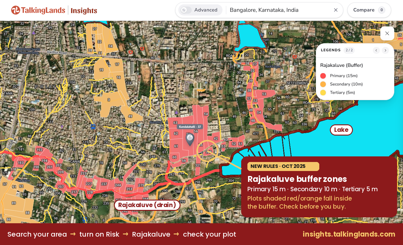
Rajakaluve buffer zones shaded on TalkingLands Insights. Tap the image to open the map.
Why the change is being challenged
Groups such as Bengaluru Town Hall opposed the draft, warning that smaller buffers would increase flood risk. Activists also argued that the cuts conflict with earlier court and tribunal positions.
A public interest litigation by Janaadhikara Sangharsha Parishat asks the Karnataka High Court to quash the final notification. According to reporting in early June 2026, a Division Bench issued notice to the State government, the Greater Bengaluru Authority (GBA) and the Bangalore Development Authority, directed them to file objections, and listed the matter for 2 September. No interim order was reported at that time. We could not find reporting on what happened next, so check the latest status before relying on either set of buffers.
Flood context explains the intensity of the debate. In September 2022, Bengaluru East and Mahadevapura were among the worst-hit zones, and Citizen Matters reported 2,626 recorded stormwater drain encroachment cases citywide, with 627 marked for demolition. The right framing is that the notification is under challenge, not struck down and not settled.
What the new rules mean for plot buyers and owners
Some land may be freed up. A plot that fell inside the old 50 m buffer may now sit outside the new 15 m buffer.
The risk does not go away. Flooding follows water, not regulations, and low-lying plots near drains can still flood.
Banks and approvals. Lenders and plan-approval authorities check drain proximity. If the High Court reverses the amendment, the earlier buffers could return.
Resale and legal risk. Buying on the strength of a reduced buffer that is still in court carries uncertainty, so speak to a property lawyer.
If you already own near a drain. Do not assume that a smaller buffer cures an old problem. Keep your sanctioned plan, completion documents and property records together, and ask the authority in writing if you are unsure which class of drain runs beside your property.
Checklist before buying near a rajakaluve
- Identify the drain type (primary, secondary or tertiary) from official records.
- Measure the distance from the plot edge to the drain on the ground and on the map.
- Ask about flood history in the area, and verify the survey number against records.
- Review approval documents, and check land ownership and the RTC.
- Check the status of the High Court case.
Rajakaluve encroachment and demolition drives
A structure built inside the buffer, or on the drain itself, is treated as an encroachment, and authorities have run demolition drives, notably after the 2022 floods. A smaller buffer does not legalise a building that sits on the drain. The Greater Bengaluru Authority, which replaced BBMP in September 2025, is now the civic body to approach.
Rajakaluve encroachment cases can also be tied up in stays and incomplete survey data, as reporting in 2022 showed, so a plot being untouched today does not prove it is clear. We are not quoting fine amounts, because we have no reliable source for them.
How to check rajakaluve buffer zone on TalkingLands Insights
- Open TalkingLands Insights and search your area or survey number.
- Open Risk in the layer bar and turn on Rajakaluve (Buffer).
- Read the legend: red is primary (15 m), orange is secondary (10 m) and yellow is tertiary (5 m).
- Zoom into your plot to see whether any shaded buffer touches it.
- Turn on the Waterbody layer too, to see nearby lakes.
- Save or compare plots before deciding.
A few reading tips help. Shaded plots show where a buffer overlaps parcel boundaries, while the thin yellow lines are the tertiary (5 m) buffers along smaller drains. The Risk panel lists other layers, such as Waterbody, Protected Area and Railway Buffer, and it marks layers with no coverage as No data, so a blank map does not always mean a clear plot. Zoom in far enough to see individual parcels, and compare against the official records for your survey number.
The map is a screening aid, not a legal clearance, and it does not show the High Court status. Rely on official records and your lawyer for anything final.

Risk → Rajakaluve (Buffer) on TalkingLands Insights. Tap the image to open the map.
Check Any Plot Before You Buy
See rajakaluve buffer shading, waterbodies and more on one map. Sign up free and get 5,000 coins.
Check Your Plot FreeFrequently asked questions
It is the no-build strip along stormwater drains. Under the October 2025 notification it is 15 m for primary drains, 10 m for secondary drains and 5 m for tertiary drains. The notification is being challenged in the Karnataka High Court.
They are the October 2025 amendment to the RMP-2015 zonal regulations (notification UDD 468 MNJ 2025), which cut the earlier buffers by more than half. A public interest litigation seeks to quash the amendment, so confirm the latest court status before relying on it.
It is 10 m under the new rules. Earlier figures reported for secondary drains are 25 m (RMP-2015) and 35 m (an NGT-era framework cited by activists), depending on the source.
Not settled. The High Court issued notice to the State, GBA and BDA in June 2026 and no interim order was reported at that time. Check the latest status before buying, and treat any claim that the rules are final and safe with caution.
Only outside the buffer and only with the required approvals. A smaller buffer does not legalise a structure on the drain itself, and flood risk remains. Check approvals and consult a property lawyer.
Use the Rajakaluve (Buffer) layer under Risk on TalkingLands Insights, or the official maps of the planning authority. A raja kaluve map is a screening aid, so confirm anything important with the authority.
Raja kaluve means king's canal in Kannada. In everyday use it refers to Bengaluru's large stormwater drains.
This is general information, not legal advice. Rules may change based on court rulings; consult a property lawyer before buying. Status checked against reporting available as of 13 October 2026.
Sources: South First: activists warn against cutting buffers · Deccan Herald: final notification · BLR Post: buffer zones reduced · Deccan Herald: High Court plea · The Hans India: HC notice · Mongabay: lake buffers


