%20(1).png)
The RTC (Record of Rights, Tenancy and Crops) — universally known as the Pahani — is Karnataka’s absolute core proof of who holds title and possession to a piece of land. Through Government Order RD-LGP/37/2026 dated 9 September 2026, the state has fundamentally redesigned its format, Form 16-A. By folding in Aadhaar-seeded ownership, a unique ULPIN, an Open Location Code, a geo-referenced survey sketch, and a dynamic QR code for instant digital verification, Karnataka is bridging the historical gap between textual records and physical geography. It is a massive leap toward making a land record something you can definitively trust and locate on a map — not just a static sheet of paper.
Key takeaways
- Karnataka has notified a redesigned Form 16-A (RTC) via GO RD-LGP/37/2026, effective from its Gazette publication.
- The new RTC integrates Aadhaar-seeded owner details (which are masked for privacy), plus a unified Farmer ID, enabling stronger identity verification.
- Every parcel now officially carries a ULPIN and Open Location Code, complete with a geo-referenced cadastral / survey sketch and an overview map.
- A QR code guarantees digital access to the verified ROR, the live mutation register, Akarbandh data, and encumbrance-related information directly from the state servers.
- The redesign does not change the legal character of the record or create/extinguish any rights — older RTCs stay perfectly valid.
- The state government has announced that over 20 lakh documents will be progressively issued in this new secure format, minimizing scope for land fraud.
- → What Is Form 16-A, and What Changed?
- → The Evolution of the RTC: Why Was a Redesign Necessary?
- → What’s New in the Redesigned RTC
- → Old RTC vs New Form 16-A: What’s Different
- → Understanding ULPIN and Open Location Code (OLC)
- → The Anatomy of the RTC: Decoding the Columns
- → How the Redesigned RTC Prevents Land Fraud
- → Why This Matters When You’re Buying Land
- → How to check this on TalkingLands Insights
- → Common Mistakes Buyers Make With RTCs
For decades, a Karnataka land buyer’s first question has been incredibly simple to ask but notoriously hard to answer with absolute confidence: does this RTC really match this piece of land, and this owner? A name and survey number printed on a Pahani did not tell you where the parcel sat geographically, whether the person standing in front of you was truly the recorded holder, or whether the paper in your hand was a genuine state-issued document or a sophisticated forgery. The state’s thoroughly redesigned Form 16-A is aimed squarely at closing that massive verification gap. For anyone executing land due diligence, from individual buyers to large institutional developers, it is vital to understand exactly what this new document contains and how it changes the title verification process.
What Is Form 16-A, and What Changed?
The RTC — Record of Rights, Tenancy and Crops, commonly known as the Pahani — is the fundamental land document maintained under the Karnataka Land Revenue Act, 1964 and its accompanying Rules of 1966. Its legally prescribed format is designated as Form 16-A. On 9 September 2026, the Revenue Department issued Government Order RD-LGP/37/2026 to redesign, enhance, and modernize that form. The new format comes into force immediately from the date of its publication in the official Gazette.
The explicit reasoning for this overhaul, articulated in the government’s own order, is that the department has made substantial, accelerated progress on statewide digitisation, Aadhaar linking, and the complex integration of authenticated databases with spatial land records (like maps and survey sketches). Because the backend technology had advanced so far, the old, purely textual form needed to catch up to provide citizens, banks, and buyers with a “more comprehensive, transparent and verifiable Record of Rights.” Crucially, the government order is careful to clarify that the redesign does not alter the fundamental legal character of the record. An RTC remains a record of possession and revenue data, not an absolute title deed, but it is now vastly more reliable.
The Evolution of the RTC: Why Was a Redesign Necessary?
To understand why this is a landmark shift, one must look at the history of Karnataka's land records. In the year 2000, Karnataka pioneered e-governance in India by launching the Bhoomi project, successfully digitizing over 20 million manual, handwritten land records previously maintained by village accountants. This eliminated massive amounts of lower-level corruption and bribery associated with issuing manual Pahanis.
However, while Bhoomi digitized the *text* (names, extents, and crops), it lacked spatial context. A digital record still couldn't visually show you where the land was located. Furthermore, the identity of the owner was recorded merely as a string of text. If "Ramesh Kumar" was listed on the RTC, there was no foolproof way to biometrically confirm which Ramesh Kumar it was, opening the door to rampant impersonation frauds during registrations at the Sub-Registrar offices.
With the subsequent introduction of Kaveri 2.0 (the state's property registration software) and the digitisation of Akarbandh and Phodi (survey and sub-division) records, the government finally possessed all the puzzle pieces. The September 2026 redesign is the culmination of bringing biometric identity, textual rights, and geographical mapping onto a single, unified sheet of paper.
What’s New in the Redesigned RTC
The revised Form 16-A brings together identity, location, and real-time verification in a way the older form never could. Here are the core structural additions:
- Aadhaar-seeded owner details: The recorded landholder’s particulars are now intricately linked to the authenticated national database. The Aadhaar number is shown masked (e.g., XXXX XXXX 1234) to protect citizen privacy, but its presence guarantees the identity has been biometrically verified by the state. For Non-Resident Indian (NRI) owners, the photo and address are pulled directly from the Kaveri database based on the registered transaction documents.
- Farmer ID (FID): A unique, state-issued identifier assigned to the recorded holder that operates alongside the masked Aadhaar, primarily used to streamline agricultural subsidies and direct benefit transfers (DBT).
- ULPIN + Open Location Code: Every parcel now displays a permanent parcel ID and a precise geo-code that irreversibly ties the textual record to a specific geographical coordinate on the earth.
- Geo-referenced survey sketch & overview map: The RTC now visually embeds a cadastral/survey sketch and a broader overview map of the survey number or hissa. The government marks this map as indicative, but it is an invaluable visual aid.
- Akarbandh integration: Direct linkage to the authenticated Akarbandh records, ensuring the land extent, boundaries, and classification (agricultural, non-agricultural, Kharab) mathematically match the state's master survey.
- QR code & digital access: By simply scanning the dynamic QR code printed on the RTC, a buyer, banker, or sub-registrar is immediately routed to the state servers to view the live, verified Record of Rights, the historical mutation register of old transactions, Akarbandh data, the survey sketch, and encumbrance-related information.
- Digital generation & authentication: The form is generated and digitally signed exclusively through the authorised state land-record system, complete with a secure barcode and a highly unique, trackable RTC number.
In short, the new RTC is purposefully built to be independently verified at a desk, checked against live servers, and visually located on a digital map — completely transforming the due diligence process.
Old RTC vs New Form 16-A: What’s Different
Here is the practical difference between the legacy RTC most buyers have seen over the past two decades and the newly redesigned Form 16-A. Treat this as your quick-reference guide to what to look for on a record. Always remember to verify that you are looking at the current, officially notified document format.
| Feature | Older Legacy RTC | Redesigned Form 16-A |
|---|---|---|
| Owner Identity | Text-based name only, highly prone to impersonation. | Aadhaar-seeded (masked for privacy) + Unique Farmer ID. |
| Parcel Identification | Basic Survey number / Hissa (sub-division) number. | Survey / Hissa + 14-digit ULPIN + Open Location Code. |
| Spatial Maps | None present on the record; required separate village maps. | Embedded geo-referenced survey sketch + visual overview map. |
| Document Verification | Manual verification required a physical office visit to the Taluk. | Dynamic QR code allows instant digital access & live authentication. |
| Linked Records | Required separate, arduous lookups for mutations and encumbrances. | QR links directly to Mutation register, Akarbandh, and encumbrance info. |
| Authenticity & Trust | Printed paper, susceptible to tampering and Photoshop alterations. | Digitally signed by the authorized system, features a barcode + unique RTC no. |
Notice the overarching theme here: every single addition is fundamentally about proof — proof of exactly who owns it, proof of exactly where it is, and proof that the document itself is undeniably real. That is exactly the checklist a careful buyer runs through anyway; the new form simply consolidates the heaviest lifting into one place.
Understanding ULPIN and Open Location Code (OLC)
Two of the most revolutionary additions to Form 16-A are the ULPIN and the Open Location Code. Understanding these is critical for modern land assessment.
The Unique Land Parcel Identification Number (ULPIN) is essentially an identity number for land. Implemented as part of the Digital India Land Records Modernization Programme (DILRMP), it is a 14-digit alphanumeric code. What makes ULPIN special is that it is generated using the exact latitude and longitude coordinates of the land parcel's vertices. Because no two parcels on earth share the exact same geographical boundaries, the ULPIN is globally unique. If an RTC has a ULPIN, it means the state has successfully matched the paper record to an actual surveyed polygon on a digital map.
The Open Location Code (OLC), also known widely as Plus Codes (developed by Google), is a geocode system for identifying any geographical area on Earth. It converts latitude and longitude coordinates into a short, easily readable string of characters and numbers (e.g., "7J4V+3Q, Bengaluru"). By having the OLC printed directly on the RTC, a buyer or bank official can type that exact code into a digital mapping application and instantly be taken to the precise location of the agricultural land, completely bypassing the need for vague, landmark-based rural addresses.
The Anatomy of the RTC: Decoding the Columns
While the format has received a high-tech facelift, the core data structure of the RTC remains fundamentally intact. Buyers still need to know how to read the vital columns of Form 16-A to spot red flags.
- Column 9 (Ownership Details): This is the most crucial section. It lists the names of the joint or sole owners, their extent of ownership (share), and now, their masked Aadhaar and Farmer ID. It also shows the mutation number through which they acquired the property (e.g., MR No. 12/2021). You must always trace this MR number to ensure the acquisition was legal.
- Column 10 (Extent and Classification): This column breaks down the total area of the survey number. Critically, it details the extent of 'Kharab' land. Kharab land is uncultivable land. 'A' Kharab is unfit for farming but belongs to the owner, while 'B' Kharab belongs exclusively to the government and absolutely cannot be sold, transferred, or converted. Ignorance of 'B' Kharab is a common trap for builders.
- Column 11 (Liabilities and Encumbrances): If the farmer has taken a crop loan, a tractor loan, or pledged the land to a cooperative society or bank, it will be listed here. You cannot legally buy this land and obtain a clear title until this encumbrance is officially discharged and struck from Column 11.
- Column 12 (Tenancy and Crops): This indicates who is actually cultivating the land and what crops are being grown. If a tenant's name appears here, it signals a massive legal risk under the Karnataka Land Reforms Act, as tenants hold significant statutory protections and potential claiming rights.
How the Redesigned RTC Prevents Land Fraud
Karnataka's real estate market, especially around booming hubs like Bengaluru, Mysuru, and Mangaluru, has historically been plagued by sophisticated land frauds. Form 16-A directly mitigates several classic scams.
Stopping Impersonation: Previously, fraud rings would identify vacant agricultural land, forge identity documents matching the text name on the RTC, and register a sale deed to a third party. Because the new RTC is Aadhaar-seeded, the sub-registrar can definitively match the biometric thumbprint of the seller to the Aadhaar hash linked to the property, neutralizing identity theft at the source.
Defeating Fake Documents: Tampering with a PDF or photocopying a genuine RTC and altering the owner's name or land extent used to be incredibly common, especially to secure fraudulent bank loans. Now, any bank manager or buyer can simply scan the printed QR code with their smartphone. If the paper says "2 Acres" but the scanned QR code opens the live Bhoomi server showing "0.5 Acres", the fraud is instantly exposed.
Resolving Boundary Overlaps: By embedding the geo-referenced survey sketch and ULPIN, the state severely limits the ability of sellers to misrepresent the physical boundaries of the land. You can no longer sell land based on a vague, unmarked stretch of dirt; the map explicitly defines the spatial reality.
Why This Matters When You’re Buying Land
A redesigned form is only truly useful if it tangibly changes how you buy and transact property. Here is exactly where the new Form 16-A alters the landscape for buyers and developers:
- Accelerated Title Search Reports (TSR): Real estate developers acquiring large 50-to-100-acre land banks traditionally spend months paying law firms to conduct exhaustive Title Search Reports. By utilizing the QR code and ULPIN, legal teams can trace mutation histories and encumbrance flow far more rapidly, drastically cutting down the legal due diligence timeline.
- Safer DC Conversion Processes: When converting agricultural land to non-agricultural (residential/commercial) use under Section 95 of the Karnataka Land Revenue Act, the Deputy Commissioner's office requires precise survey data. The geo-referenced sketch embedded in the new RTC heavily streamlines this bureaucratic process, leading to faster layout approvals.
- Fewer Surprises After Sale: The state government actively frames this redesign as moving toward "finality" and conclusive titling in land ownership. The entire objective is to ensure that fewer ancestral disputes, boundary overlaps, and hidden bank loans surface years after you have purchased the land.
However, none of this completely replaces the need for independent due diligence — it merely sharpens and empowers it. You still absolutely must read the RTC alongside the parcel’s physical boundaries, verify the mutation status, pull the EC (Encumbrance Certificate), and check for ecological risk layers before you commit vast sums of capital. That is precisely where seeing the record on a spatial map matters immensely. (If you are new to reading these specific records, we highly recommend starting with our foundational guide on how to check RTC / Pahani online in Karnataka.)
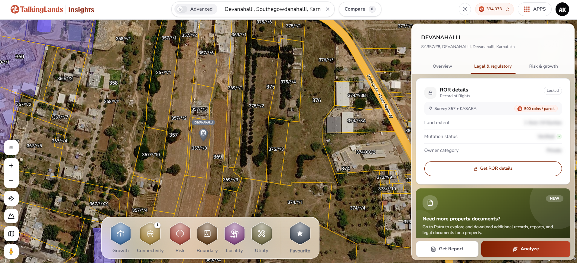
A digitized parcel at Devanahalli visualized on TalkingLands Insights — view the exact survey number, physical boundaries, and the integrated Record of Rights panel in one seamless interface. Click the image to explore your location.
How to check this on TalkingLands Insights
You do not have to wait for the new-format paper to physically arrive in your hands to start verifying a parcel spatially. On the TalkingLands Insights platform, you can confidently check the legal parameters of almost any location in Karnataka in about a minute:
- 1. Search and Locate: Enter the specific location, village name, or exact survey number into the map search bar to seamlessly fly to and isolate the exact parcel of land.
- 2. Open Legal & Regulatory: Click on the parcel to open the legal panel. Here you can instantly view the live Record of Rights — extracting critical data such as the total land extent, the number of joint owners, the land classification, and the current mutation status.
- 3. Check Risk & Growth Layers: A clean RTC does not mean the land is safe to build on. Utilize the platform to scan for environmental buffers, Rajakaluve (stormwater drain) proximities, designated flood zones, and Master Plan zoning regulations on the exact same parcel before you proceed further.
- 4. Click Get Report: Easily pull a comprehensive, downloadable property report, and request the official ROR / Pahani extract to secure the formal government record for your files.
- 5. Final Confirmation: Armed with this data, confidently cross-confirm the details against the official notified Bhoomi record and present your findings to a qualified property lawyer before you commit to signing a sale agreement.
ROR details and official extracts on the platform are credit-based, ensuring you only pull the intensive records you actually require for your transaction. If you prefer to navigate the manual portal route as well, please refer to our comprehensive Bhoomi Karnataka land-records portal guide for step-by-step government website instructions.
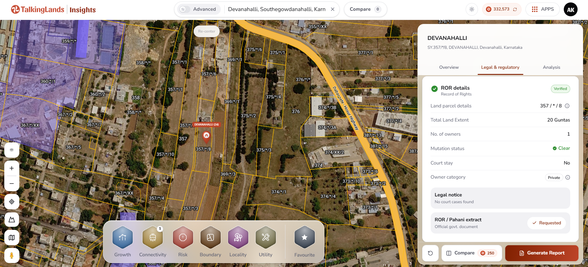
A highly verified Record of Rights on TalkingLands Insights — confirming the parcel geometry, total extent, mutation status, and owner category, fully ready to generate an executive report. Click to try it yourself.
Common Mistakes Buyers Make With RTCs
Even with advanced digital tools, human error remains the biggest vulnerability in real estate transactions. Avoid these critical mistakes when dealing with land records:
- Confusing RTC with Khata: This is the most common error in Bengaluru. An RTC (Pahani) is proof of title for agricultural land. A Khata is merely an administrative tax document for municipal properties (like BDA or BBMP plots). Having an RTC does not mean you have layout approval, and having a Khata does not conclusively prove title.
- Trusting the paper alone: As emphasized, a printed name on an RTC is not absolute proof that the physical parcel, the demarcated boundaries, and the seller standing before you all magically line up. You must demand the 11E Sketch (Tippan) and match it physically to the map and the on-ground survey sketch.
- Skipping mutation & encumbrance checks: The RTC is merely the top layer of the onion. You must tirelessly check the mutation status to ensure the current seller legally acquired it from the previous owner. Furthermore, checking for active court stays, pending litigation, and pulling a 15-year Encumbrance Certificate (EC) before you trust the ownership is strictly mandatory.
- Overlooking 'B' Kharab or PTCL Status: Failing to notice that a portion of the land is 'B' Kharab (government-owned) means you are paying for land you can never use. Similarly, failing to check if the land was granted to marginalized communities under the PTCL Act means the sale could be legally voided entirely, leading to catastrophic financial loss.
- Assuming the high-tech format alone guarantees safety: A new-format, QR-coded Form 16-A is a brilliant tool, but it still fundamentally relies on the data entered into the system. It still needs to be rigorously verified against the live Bhoomi record, the physical reality on the ground, and subjected to an exhaustive legal review by a competent property advocate.
Conclusion
Karnataka’s newly redesigned RTC (Form 16-A) is arguably the most significant modernization of state land records since the inception of the Bhoomi project over two decades ago. By successfully intertwining textual ownership data with biometric identity, unique digital parcel identifiers (ULPIN), and spatial mapping logic, the state has made a land record vastly easier to trust, verify, and place definitively on a map. This is a massive, tangible gain for property buyers, agricultural lenders, and real estate developers across the state.
However, technology is only an enabler, not a replacement for diligence. As a buyer, you must leverage this new transparency. Read the RTC dynamically on the map, pull the intricately linked mutation and encumbrance records, and rigorously verify the source. By doing so, you effectively turn what was once a blind leap of faith into a secure, mathematically checked, and legally sound financial decision.
Check your location on TalkingLands Insights
Instantly search any survey number, visualize the parcel with its precise geographical boundaries and live Record of Rights, and pull an exhaustive property report — absolutely before you commit to buying. Sign up free today and get 5,000 coins.
Check my location freeFrequently asked questions
Form 16-A is the legally prescribed format of the RTC (Record of Rights, Tenancy and Crops) under the Karnataka Land Revenue Rules, 1966. Through Government Order RD-LGP/37/2026 dated 9 September 2026, the state comprehensively redesigned it to integrate Aadhaar-seeded owner details, a ULPIN (Unique Land Parcel Identification Number), an Open Location Code, a geo-referenced survey/cadastral sketch, and a dynamic QR code for instant digital verification — coming into full force from the date of its official Gazette publication.
No, absolutely not. The Government Order explicitly states the redesign does not alter the fundamental legal character of the Record of Rights, and does not by itself create, extinguish, or arbitrarily transfer any right, title, or interest in the land. The update solely enhances administrative transparency, spatial accuracy, and digital verifiability — all existing legacy records stay perfectly valid, while the new-format RTCs are issued for all requests going forward.
ULPIN (Unique Land Parcel Identification Number) is a permanent, 14-digit alphanumeric ID for a specific parcel, functioning much like an identity number specifically for land, based on its geographical coordinates. Open Location Code (Plus Codes) is a short, readable geo-code that pinpoints the parcel’s precise location on the globe. Together with the geo-referenced survey sketch, they allow anyone to accurately match the printed paper record to an exact spot on a digital map — though the map is provided for indicative verification purposes only.
You can simply search the survey or hissa number on the TalkingLands Insights platform. From there, open the Legal and regulatory panel to immediately see the live Record of Rights, the current mutation status, and detailed owner information, while simultaneously viewing the parcel visually on the map. You can then pull a full property report and request the official ROR / Pahani extract, allowing you to confirm all details against the official state Bhoomi record and consult a lawyer before you execute a purchase.
While no single document can end all litigation, the new RTC is purposefully designed to drastically reduce disputes by powerfully combining spatial verification with secure digital authentication and Aadhaar-seeded identity. The government has confidently stated that over 20 lakh documents will be issued in this highly secure new format. It enormously strengthens the verification process, but cautious buyers must still diligently run full legal due diligence — cross-verifying the RTC alongside the encumbrance certificate, mutation flow, physical survey sketch, and securing a comprehensive legal review — before committing any funds.
Disclaimer: This article is intended for general informational and educational purposes as of September 2026 and does not constitute formal legal advice. The redesigned Form 16-A is officially notified via GO RD-LGP/37/2026 and formally takes effect upon its Gazette publication; administrative rollout timelines and specific record contents may vary across districts. Always verify the current, notified land record directly on the state Bhoomi portal and consult thoroughly with a qualified property advocate before buying, selling, or developing any land.
.png)