.png)
Thippagondanahalli (TG Halli) Reservoir Buffer Zone: What Land Buyers Must Check (2026)
You spot an incredibly enticing listing for a plot in Western Bengaluru, somewhere along Magadi Road or near Tavarekere. The price is drastically lower than equivalent land in other parts of the city. The broker tells you it’s a "distress sale" and assures you that residential development is booming in the area. You buy the plot, ready to construct your dream home or a lucrative commercial layout.
When you submit your architectural plans for approval, the municipality rejects them instantly. You are informed that your plot sits squarely inside the Thippagondanahalli (TG Halli) reservoir buffer zone. Your title is effectively frozen. You cannot legally construct a residential layout, secure a DC conversion, or establish commercial infrastructure.
This scenario traps hundreds of unwary buyers every year. The TG Halli catchment carries some of Bengaluru's strictest—and most heavily litigated—environmental development restrictions. To protect the city's drinking water, massive tracts of land on the western and north-western periphery are heavily regulated.
Whether you are looking at land in Nelamangala, Dasanapura, or the Kunigal belt, this is your complete 2026 guide to understanding the TG Halli buffer rules, the four distinct restriction zones, and exactly how to scientifically verify a plot's safety before you buy.
Quick Answer: The Thippagondanahalli (TG Halli) reservoir catchment is a highly protected ecological zone in Western Bengaluru where non-agricultural development is severely restricted. Based on an evolving legal framework spanning from 2003 to 2026, the catchment is divided into four strict zones, with complete bans on mining, untreated commercial discharges, and unauthorized layouts near the Arkavathy and Kumudvathi riverbanks. Before buying any "cheap" plot in this belt, you must overlay its exact survey number on a spatial Risk layer (like TalkingLands Insights) to ensure it does not fall inside an unbuildable buffer.
What Is the TG Halli Reservoir & Why Does It Matter?
Thippagondanahalli (TG Halli) Reservoir—also known as Chamarajasagara—was constructed in 1933 at the confluence of the Arkavathy and Kumudvathi rivers, roughly 35 kilometers west of Bengaluru. For decades, it was a primary source of drinking water for the city.
However, rapid, unregulated urbanization, industrial effluent discharge, and massive groundwater over-extraction slowly degraded the water quality and drastically reduced natural inflows. By 2012, the Bangalore Water Supply and Sewerage Board (BWSSB) was forced to halt the supply of drinking water from the reservoir.
To revive the rivers and save the reservoir, the Karnataka Government implemented aggressive, far-reaching restrictions across the entire catchment basin. For real estate buyers, this means that thousands of acres of land stretching far beyond the immediate water body are subject to draconian building restrictions.
The Rules & Timeline: A Legal Maze
The regulations governing this area are notorious for shifting as environmental groups and developer lobbies clash in court. Here is the factual timeline you must understand:
- The 2003 Eco-Protection Notification: The state government originally notified the catchment area under the Environment (Protection) Act of 1986. This foundational order divided the region into four distinct zones, placing severe bans on non-agricultural developments within a 1 km radius of the riverbanks and a 2 km radius of the reservoir to prevent urban runoff.
- The July 2019 GO (Government Order): After intense pressure, the government attempted to re-classify and relax these buffer zones, sparking a fierce wave of public interest litigation before the National Green Tribunal (NGT) and the High Court.
- The January 2026 Order & Ongoing Debate: Currently, a massive legal and political battle is underway regarding the dilution of these buffers. Recent 2026 directives attempt to enforce strict zero-discharge systems and ban fresh mining leases, while simultaneously fielding proposals to shrink the riverbank development ban from its historic 1 km radius down to just 30 meters. Because these rules are actively contested in court, relying on a broker's outdated knowledge is incredibly dangerous.
The Four Catchment Zones (2026 Status)
The government classifies the TG Halli catchment into four specific zones. The level of restriction depends entirely on where your survey number lands.
TG Halli Catchment — The 4 Zones
(Note: As per the latest notified orders and historic frameworks. The exact riverbank buffer distances—specifically the dilution from 1 km down to 30 meters—are actively contested in court. Always verify the current spatial status locally.)
.png)
Affected Areas: Where Is the Risk Highest?
The catchment is enormous, capturing rainfall across several major districts before funneling it into the reservoir. If you are buying land in any of the following corridors, you must perform a catchment verification:
- Magadi Road Belt: Particularly the stretches around Tavarekere, Cholanayakanahalli, and Doddamagadihalli.
- Nelamangala & Dasanapura: Properties south of the Tumkur highway that slope topographically toward the Arkavathy basin.
- Kunigal Corridor: Land parcels along the NH75 highway fringes that fall into the western watershed.
- Dodballapur / Nandi Hills Feeders: The northern stretches where the river network originates.
Why Buyers Get Trapped
The classic trap works like this: a developer buys agricultural land inside Zone 2 or Zone 3 for a fraction of its market value. They illegally carve out residential plots without securing municipal DC conversion or BDA/BMRDA approvals. They market the land heavily as "affordable western Bengaluru investment plots."
Because the land sits on an open field, buyers do not realize they are legally inside a restricted catchment area. Years later, when the buyer attempts to get an e-Khata or apply for a building sanction, the local authority references the active ecological notification and rejects the application. The buyer is left holding frozen, unbuildable land that is impossible to resell.
How to Check if Your Plot Is in the Catchment
You cannot determine if your land is inside a 2 km buffer or a 30-meter riverbank setback by pacing it out on foot. You must verify the geographical coordinates against the state’s gazetted spatial boundaries.
By logging into TalkingLands Insights, you can execute a flawless digital verification:
- Locate the Plot: Enter your village name and precise survey number.
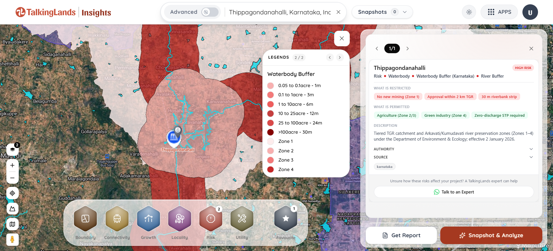
- Activate the Risk Layer: Turn on the "Protected Area / Risk" layer. The platform will automatically overlay the exact cadastral boundary of your plot against the official TG Halli catchment zones and river buffers.
- Assess the Legality: You will instantly see if your land falls within a restricted Zone 2 or Zone 3, or if it safely clears the buffer restrictions.
By combining this with an overlapping check for water body buffer zones and general zoning regulations, you eliminate the blind spots that bankrupt unwary buyers.
What to Verify Before You Buy
If you are determined to purchase land anywhere in the Bengaluru West or North-West periphery, follow this strict verification checklist:
- The Cadastral Overlay: Do not rely on physical roads or fences. Map the survey number digitally to prove it sits entirely outside Zones 2 and 3 of the TG Halli notification.
- The Plan Sanction: If a developer claims they have a "legally approved layout" inside Zone 4, demand to see the official BMRDA or BDA plan sanction, ensuring the zero-discharge sewage treatment conditions are explicitly met and documented.
- The Lake & Rajakaluve Network: Even if you clear the TG Halli reservoir limits, this entire belt is riddled with feeder streams and drains. You must independently check the Rajakaluve buffer zones to ensure your specific plot boundary is not sitting inside a localized drainage setback.
- Land Conversion Status: Ask for the DC conversion order. Revenue authorities will not issue an official residential land-use conversion for agricultural land trapped inside the core restricted catchment zones.

Frequently Asked Questions
1. What is the TG Halli buffer zone?
The Thippagondanahalli (TG Halli) buffer zone is a heavily protected ecological catchment area in Western Bengaluru, established to protect the Arkavathy and Kumudvathi rivers from pollution and urban runoff. It restricts construction and industrial activities over a vast geographical area.
2. Can I build a house if my land is in the TG Halli catchment?
It depends entirely on the zone. In Zone 2 (within 2 km of the reservoir) and Zone 3 (riverbanks of Arkavathy/Kumudvathi), non-agricultural construction is generally strictly prohibited. In the outer Zone 4, residential layouts may be permitted, but only under extremely stringent conditions, including mandatory zero-discharge sewage treatment systems.
3. Which areas in Bengaluru are affected by the TG Halli restrictions?
The catchment primarily affects the western and north-western peripheries, covering massive tracts of land across Magadi Road, Tavarekere, Nelamangala, Dasanapura, parts of the Kunigal corridor, and the river origins near Dodballapur and Nandi Hills.
4. Are the buffer zone distances finalized?
No. While the original 2003 order established strict 1 km to 2 km buffers, there is an intense, ongoing legal and political debate regarding the dilution of these zones (with active proposals to shrink the riverbank buffer to 30 meters). Because the regulations are actively shifting in court, buyers must independently verify the real-time spatial status of any plot.
5. What happens if I buy a plot inside the restricted zone?
If your plot falls into a restricted zone (like Zone 2 or 3), your title becomes legally frozen for urban development. The municipality will refuse to issue building plan approvals, you cannot legally convert the land from agricultural to residential use, and reselling the property becomes incredibly difficult.
6. How can I check if my survey number is in the TG Halli catchment?
You must execute a spatial verification. By utilizing a platform like TalkingLands Insights, you can enter your survey number and overlay it directly onto the official Protected Area and Risk layers, instantly revealing if the plot intersects with the restricted TG Halli zones or river buffers.
.png)

.png)


