%20(1).png)
Water Body Buffer Zones in India: How Far From a Lake or Tank You Can Build (2026)
The Lake-View Illusion
A lake-facing plot is often marketed as the ultimate real estate trophy. The developer promises unobstructed views, a cool breeze, and premium appreciation. You pay a 25% premium for the location and begin drafting architectural plans for a waterfront villa.
When you submit those plans to the local municipal authority, they are instantly rejected.
The reason? Your premium plot sits 20 meters from the water's edge, placing it squarely inside a legally protected, non-buildable water body buffer zone. The land you purchased is legally classified as an environmental dead-zone. You cannot build a house, lay a foundation, or even construct a permanent compound wall.
In India, building near water is governed by some of the strictest, yet most misunderstood, environmental regulations in the real estate sector. The rules are not uniform; a massive notified lake carries a completely different buffer requirement than a small village tank (kere).
Whether you are buying a holiday home or assembling land for a massive township, here is the definitive 2026 guide to understanding water body buffer zones, how the size of the lake dictates the restriction, and how to scientifically check your plot's distance before you pay an advance.
Quick Answer: A water body buffer zone is a mandatory "no-development" area around lakes, tanks, and ponds. The required distance varies based on the governing authority and the size of the water body. While the National Green Tribunal (NGT) and specific lake authorities often enforce flat 30-meter to 75-meter buffers for major notified lakes, smaller water bodies generally follow a size-graded rule (e.g., a 1-acre tank might require a 3-meter buffer, while a 100-acre lake requires 30 meters). To know exactly what applies, you must overlay your survey number on a spatial map like the TalkingLands Waterbody Buffer layer.
What is a Water Body Buffer Zone?
A buffer zone is a designated perimeter of land immediately surrounding a water body (lake, tank, pond, or river) where permanent construction is strictly prohibited.
These "No-Development Zones" (NDZs) exist to serve three critical functions:
- Preventing Encroachment: Stopping the gradual filling-in of lakes by private developers looking to expand their land area.
- Flood Mitigation: Leaving a permeable land buffer allows excess water to naturally swell during heavy monsoons without flooding concrete structures.
- Ecological Protection: Shielding the water body from direct raw sewage runoff, construction debris, and light pollution.
Why It Matters for Buyers (The Risks)
Ignoring buffer zone rules carries devastating financial and legal consequences for property buyers:
- Immediate Plan Rejection: Municipal planning authorities (like the BDA, BBMP, or local town planning boards) will not sanction a building plan if the cadastral footprint of your survey number breaches the required buffer.
- The Demolition Threat: If a builder illegally constructs an apartment inside a buffer, environmental courts (like the NGT) can—and frequently do—order retroactive demolition, offering zero compensation to the homeowners.
- Severe Flooding: Buffer zones are essentially natural flood plains. If you build inside one, your property is geographically guaranteed to flood during extreme weather events.
How Buffer Distance is Set: The Two Regimes
The most common mistake buyers make is assuming there is one universal, flat rule for every drop of water in India. In reality, you must navigate two different regulatory regimes depending on the specific water body.
1. The NGT / Lake Authority Regime (Major Lakes)
For large, officially notified lakes (especially in major metros like Bangalore), buffer zones are typically governed by National Green Tribunal (NGT) rulings or dedicated Lake Development Authorities.Historically, these bodies enforce strict, flat-distance buffers ranging from 30 meters to 75 meters from the Full Tank Level (FTL) of the lake. (For a deep dive into how these specific city-level rulings are evolving, read our update on the Bangalore Lake Buffer Zone Rules).
2. The Size-Graded Extent Rule (Tanks, Keres, and Ponds)
What if the water body isn't a massive 200-acre notified lake, but a smaller 2-acre village tank (kere) adjacent to a suburban layout?
For un-notified or smaller water bodies, town planning authorities generally apply a size-graded buffer rule. The logic is simple: the larger the extent (size) of the water body, the wider the required buffer zone.
Below is the standard size-graded classification used to determine preliminary spatial risk.
Water Body Buffer by Size (Indicative)
Warning: This table represents typical size-graded spatial buffering rules. The exact legally enforced distance varies by state law, local master plan, and environmental rulings. Always verify the specific prevailing authority for your plot.
.png)
Overlapping Environmental Risks
Lakes and tanks do not exist in isolation. If a plot is dangerously close to a water body, it is highly likely to trigger other severe environmental spatial restrictions.
When evaluating a lakeside plot, you must simultaneously check for:
- Rajakaluve (Stormwater Drain) Buffers: Lakes are fed and drained by a network of primary, secondary, and tertiary drains, which carry their own massive Rajakaluve buffer zones (often 15m to 50m).
- Valley Zones: Municipal master plans often classify the entire topographical dip surrounding a lake as a "Valley Zone," placing a blanket ban on commercial or high-density residential development.
- Flood Zones: Low-lying areas near water bodies carry severe inundation risks. (Read our guide on How to Find Risk Associated with Land to map flood topologies).
- Coastal Regulation Zones (CRZ): If the water body connects to tidal or coastal waters, an entirely different set of CRZ rules dictates development.
How to Check a Plot's Distance Before Buying
You cannot measure a buffer zone with a tape measure on site. Buffer lines are drawn from the officially recorded edge of the water body in the government's spatial maps, not where the water happens to be during the dry season.
Furthermore, some lakes are completely dried up and built over, but they still exist as "active water bodies" on government revenue maps. If you build there, your structure is illegal.
Map the Risk Instantly with TalkingLands
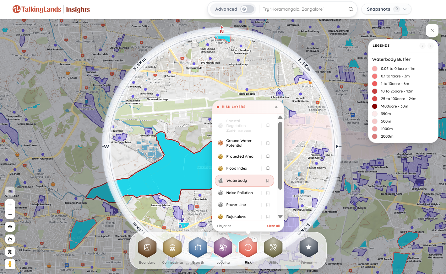
To accurately verify your plot, you need professional spatial intelligence. By dropping your survey number into TalkingLands Insights, you can instantly overlay the plot's exact cadastral boundary onto a live satellite map.
Simply activate the Waterbody Buffer layer. The platform automatically calculates the extent of nearby lakes, tanks, and ponds, and projects the corresponding size-graded buffer rings. You can instantly see if your survey number clears the restricted zone, protecting your capital before you make an irreversible mistake.

Frequently Asked Questions
1. What is a water body buffer zone?
A water body buffer zone is a mandatory, legally protected perimeter of land surrounding a lake, pond, tank, or river where permanent construction and development are strictly prohibited to prevent flooding and ecological damage.
2. How far do I need to build away from a lake?
The required distance depends on the size of the lake and the governing authority. For major notified lakes, the National Green Tribunal (NGT) and specific lake authorities often enforce a flat 30-meter to 75-meter buffer. For smaller, un-notified tanks and ponds, town planning authorities generally use a size-graded scale (e.g., a 12-meter buffer for a 15-acre tank).
3. Can I build a compound wall inside a lake buffer zone?
No. Local municipal authorities and environmental courts prohibit the construction of permanent brick-and-mortar compound walls inside a notified buffer zone, as they impede the natural flow of surface water and disrupt the floodplain.
4. What happens if I buy a plot inside a buffer zone?
If your plot falls entirely inside a buffer zone, it is legally unbuildable. The municipal planning authority will reject your building plan sanction. If a structure is built illegally, it is subject to immediate demolition by civic authorities without any financial compensation.
5. The lake near the plot is completely dried up. Does the buffer still apply?
Yes. Buffer zones and water body classifications are based on government revenue maps and master plans, not current physical water levels. Even if a lake has been dry for a decade, if it is marked as a water body in the official cadastral records, the strict buffer rules still apply.
6. How can I check if my survey number is in a buffer zone?
Because buffer lines are invisible on the ground, you must use a spatial intelligence platform like TalkingLands. By overlaying your specific survey number against the digital Waterbody Buffer layer, you can instantly measure the exact distance from your plot to the official edge of the water body.
.png)

.png)


