ALL Posts
July 25, 2026
.
11 mins read
Devanahalli Master Plan / CDP 2026: Zoning, Growth Zones & What Buyers Must Check

Devanahalli Master Plan / CDP 2026: Zoning, Growth Zones & What Buyers Must Check

Everyone wants a piece of the Bengaluru airport corridor. Driven by the massive expansion of Kempegowda International Airport (KIA), the rise of KWIN City, and a booming Aerospace SEZ, the Devanahalli belt has transformed from a sleepy northern suburb into the most aggressive wealth-creation corridor in South India.

However, with unprecedented growth comes unforgiving regulation. Countless investors buy plots marketed as "future luxury villa sites" only to discover later that the land sits squarely inside a protected green belt or an airport flight-path funnel zone where building is severely restricted.

In this corridor, your investment is entirely dictated by one document: the Devanahalli Master Plan (governed by BIAAPA). It decides whether your plot will yield massive commercial returns or remain permanently frozen as agricultural land. Here is your definitive 2026 guide to understanding the airport corridor's zoning, the explosive growth nodes, the critical airport height restrictions, and exactly how to check a plot's buildability before you buy.

Quick Answer: The Devanahalli Master Plan (officially the BIAAPA Master Plan) dictates the legal land use for over 200 villages surrounding the Kempegowda International Airport. It categorizes land into distinct zones—Residential, Commercial, Industrial/Aerospace, and Green Belts. Even if a plot sits next to a massive tech park, if it is zoned "Green," it cannot be legally developed for housing. Furthermore, properties in this belt are subject to strict AAI (Airports Authority of India) height restrictions. Before buying, always overlay the exact survey number on a spatial zoning layer to verify its Master Plan status, KIADB acquisition risk, and height limits.

What Is the Plan & Who Governs It?

Unlike the central city, which is governed by the BDA (and the broader Bangalore CDP-2031), the airport corridor operates under a specialized authority.

The master plan for this region is prepared and administered by the Bangalore International Airport Area Planning Authority (BIAAPA). Formed under the Karnataka Town and Country Planning Act, BIAAPA was established specifically to ensure that the massive urbanization triggered by the airport does not collapse into chaotic, unplanned sprawl.

BIAAPA’s jurisdiction covers Devanahalli town and over 200 surrounding revenue villages. The Master Plan (or Comprehensive Development Plan - CDP) is the legally binding framework that divides this entire geography into color-coded zones. It dictates FAR (Floor Area Ratio), setback requirements, and fundamentally, what you are legally allowed to build on any given survey number.

(Note: During recent delimitations, certain villages on the Doddaballapur side were shifted to the Doddaballapura Planning Authority. Always verify which local authority currently holds jurisdiction over your specific survey number).

Key Land-Use Zones: What You Can Actually Build

Understanding the BIAAPA zoning categories is the first and most critical step of due diligence in Devanahalli. A common trap involves brokers carving up "Green Zone" agricultural land and selling it as residential plots without securing a Change of Land Use (CLU) order.

Below is a breakdown of the primary land-use zones as per the notified master plan:

Devanahalli Master Plan — Land-Use Zones

(Note: As per the notified BIAAPA Master Plan. Always verify the current spatial status for your exact parcel).

Zone What It Allows Buyer Note / Red Flag
Residential (Yellow) Housing, apartments, gated villa layouts, and localized retail. Highly sought after. If the land is currently agricultural, it still requires a formal Change of Land Use (CLU) order to be legally developed.
Commercial (Blue) Retail centers, offices, hotels, logistics hubs, and mixed-use. Clustered near the airport and main highways (NH-44). Highest land valuation in the corridor.
Industrial / Aerospace (Purple) Manufacturing, hardware parks, IT/BT SEZs, and aerospace vendors. Largely acquired and managed by KIADB. Private residential development is strictly prohibited here.
Agricultural / Green Belt (Green) Farming, nurseries, and highly restricted sparse farmhouses. Massive Red Flag. BIAAPA rarely allows residential CLU in Green Zones. Do not buy plotting layouts here.
Public / Semi-Public (Red) Utilities, government offices, hospitals, educational institutions. Reserved for civic amenities. Cannot be bought for private residential use.

Growth Nodes Shaping the Corridor

The Devanahalli master plan is not just lines on paper; it is anchored by massive, multi-billion-dollar infrastructure nodes that dictate the flow of private capital.

  1. Kempegowda International Airport (KIA) & T2: The epicenter of the corridor. The operationalization of Terminal 2 has doubled passenger capacity, turning the immediate vicinity into a premium hospitality and commercial zone.
  2. KIADB Aerospace SEZ & Hardware Park: Spread across thousands of acres near Bagalur and Devanahalli, this node hosts facilities for global players like Boeing, Airbus, and Foxconn. It is the primary engine driving demand for residential townships in the area.
  3. KWIN City (Knowledge, Wellbeing, and Innovation City): Located towards the Doddaballapur-Dobbaspet axis but deeply impacting the Devanahalli growth narrative. Read our complete guide to the KWIN City Master Plan to understand its massive residential spillover effect.
  4. Satellite Town Ring Road (STRR): This massive highway infrastructure seamlessly connects Devanahalli to Doddaballapur, Hoskote, and beyond, opening up previously inaccessible agricultural lands for massive logistics and warehousing zoning.
  5. Devanahalli Business Park & ITIR: Proposed massive tech and business enclaves that are fundamentally restructuring the commercial zoning boundaries along NH-44.

The Airport Overlay: AAI Height Restrictions

One of the most unique—and frequently overlooked—aspects of the Devanahalli Master Plan is that it operates beneath an invisible ceiling.

Because of the flight paths descending into KIA and the nearby Yelahanka Air Force Station, the Airports Authority of India (AAI) enforces strict color-coded height restriction zones (funnel zones) over the entire region.

  • The Reality: You might purchase a plot with a "Commercial" BIAAPA zoning that theoretically allows for a 10-story glass office building. However, if that plot sits inside an aggressive AAI funnel zone, your permissible building height might be capped at just 2 or 3 stories.
  • The Fix: Every high-rise or significant commercial project in this corridor requires an explicit No Objection Certificate (NOC) for height clearance. Learn exactly how this impacts developers in our deep dive on Airport Zoning and Building Height Restrictions.

How to Check a Plot's Zoning Under the Plan

Do not rely on a broker pointing to a printed, outdated map. The only way to securely verify a plot is to digitally cross-reference it against the gazetted master plan.

With TalkingLands Insights, checking your zoning takes seconds:
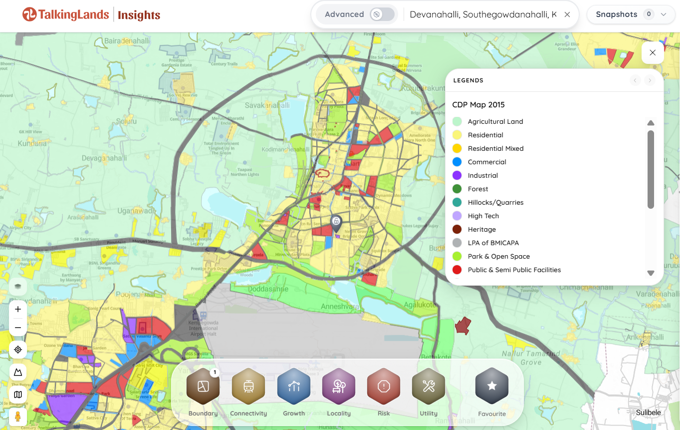
  1. Locate the Plot: Enter the specific village name and exact Survey Number.
  2. Activate the CDP / Zoning Layer: The platform will instantly pull the official BIAAPA land-use color code directly over your plot's boundaries.
  3. Check Overlays: On the same screen, you can activate the AAI Airport Height Restriction layer and local environmental buffer layers to get a holistic view of buildability.

Verify Your Devanahalli Plot's Zoning

Is your plot truly residential, or is it trapped in a green belt? Sign up free and get 5,000 free coins to check the exact Master Plan zoning, airport height limits, and acquisition risks for any survey number instantly.

Or call us directly: +91 70260 88339

What Buyers MUST Verify Before Investing

If you are committing capital to the airport corridor, paper documents alone are not enough. Run your property through this spatial checklist:

  1. Master Plan Zoning: Determine if the land is strictly zoned for your intended use (Residential/Commercial). Learn the exact steps in our guide on how to find the zoning of a property.
  2. DC Conversion & CLU Status: If the Master Plan marks it as Residential, but the current revenue records still say "Agricultural," ensure the developer has secured a formal DC Conversion and a BIAAPA Change of Land Use (CLU) order.
  3. Airport Height Limits: Verify the plot against the AAI color-coded NOC grid to ensure your structural plans are not grounded by flight paths.
  4. KIADB Acquisition Zones: Massive industrial parks are still expanding. Ensure your survey number has not been issued a preliminary acquisition notification by the government.
  5. Ecological Buffers: North Bengaluru is dotted with historic lakes (keres) and stormwater drains (rajakaluves). Encroaching on these buffers will permanently block your building sanctions.

Buying Land or Plots in the Airport Corridor?

The Devanahalli belt is highly lucrative but densely regulated. Share your requirements and let our team help you find, verify, and secure legally cleared plots in the right zones.

Tell Us Your Requirement

TalkingLands provides spatial verification and connects you with verified partners — we do not sell plots directly.

Frequently Asked Questions

1. What is the Devanahalli Master Plan?

The Devanahalli Master Plan, officially governed by the Bangalore International Airport Area Planning Authority (BIAAPA), is the statutory land-use framework for Devanahalli town and over 200 surrounding villages. It dictates zoning laws, permitted construction types, and urban expansion around the airport.

2. Can I build a house on agricultural land in Devanahalli?

No. To legally build residential structures on agricultural land, two things must happen: the BIAAPA Master Plan must designate the area as a "Residential Zone," and the landowner must secure a formal Change of Land Use (CLU) and DC Conversion order from the authorities.

3. What does BIAAPA approved mean?

A "BIAAPA approved" layout means the developer has submitted their residential or commercial plans to the planning authority, paid the betterment charges, dedicated mandatory space for roads and civic amenities, and secured legal permission to carve the land into buildable plots.

4. Are there height restrictions for buildings near the Bangalore airport?

Yes. The Airports Authority of India (AAI) enforces strict color-coded funnel zones around Kempegowda International Airport and the Yelahanka Air Force Station. Buildings inside these zones have strict elevation caps to ensure clear flight paths, and developers must secure explicit NOCs before construction.

5. What are the main growth zones in the Devanahalli corridor?

The major economic nodes include the Airport Terminal 2 expansion, the KIADB Aerospace SEZ and Hardware Park (Bagalur), the upcoming KWIN City, the Satellite Town Ring Road (STRR) intersections, and the Devanahalli Business Park.

6. How do I check if my plot is in a BIAAPA Green Zone?

You can verify the zoning by cross-referencing your exact survey number against the officially notified BIAAPA Master Plan maps. For an instant, digitized check, use the TalkingLands Insights platform to overlay the CDP zoning layers directly onto your parcel.

Recent Posts
See All
TalkingLands Technologies Pvt Ltd, No.125, G K Arcade , Ashoka Pillar main road, Jayanagar East, Bengaluru, Bengaluru Urban, Karnataka, 560011
Get the latest news and updates

Subscribe TO RECEIVE LATEST UPDATES

Thank you! Your submission has been received!
Oops! Something went wrong while submitting the form.
© 2023 TalkingLands Pvt Ltd. All rights reserved.