Land Management Software (2026): What It Is, Key Features & How Enterprises Manage Land at Scale
Land Management Software (2026): What It Is, Key Features & How Enterprises Manage Land at Scale
When an infrastructure firm holding 2,000 acres across three Indian states attempts to operate without dedicated land management software, it inevitably loses the thread of its own portfolio. Because the data lives in fragmented, offline Excel spreadsheets and locked filing cabinets, critical vulnerabilities go unnoticed.
When they attempt to break ground on a new solar park, they discover systemic encroachments on the boundary no one caught. They find expired leases on commercial land they forgot to renew. They realize that two crucial parcels are locked in civil litigation with no central view of the case status. The land is officially on the company's books, but it is bleeding millions in lost value. This is the classic, unavoidable cost of managing enterprise land without a centralized system.
To protect land assets, leading developers, PSUs, and institutional funds have abandoned manual spreadsheets for enterprise land management platforms. Here is your complete 2026 guide to what a land management system is, its core operational modules, how it differs from acquisition software, and how enterprises use it to manage sprawling portfolios at scale.
Quick Answer: Land management software is an enterprise GIS (Geographic Information System) and MIS platform that digitizes, maps, tracks, and manages a land portfolio across its entire lifecycle. It centralizes land records, ownership status, encroachment monitoring, lease tracking, compliance, and valuation in one place. It is used by developers, infrastructure/industrial firms, PSUs, and government bodies to replace chaotic spreadsheets and physical files. (Note: Land management software manages land you already hold; land acquisition software helps you buy it).
What It Is & Who Needs It
At its core, a Land Management System (LMS) bridges the gap between spatial geography (where the land is) and legal documentation (who owns it and what its status is). It creates a single source of truth for an entire real estate portfolio.
Who uses it?
Developers & PE Funds: To manage large, master-planned land banks awaiting development.
Industrial & Infrastructure Estates: Firms managing massive plant footprints, right-of-way (RoW) alignments, and resettlement records.
PSUs & Government Bodies: State departments overseeing public land, monitoring lease allocations, and controlling illegal encroachment.
REITs: Trusts requiring rigorous portfolio oversight and compliance tracking for audits.
Land Management Software — Key Modules
Module
What It Does
Why It Matters
GIS Parcel Mapping
Overlays cadastral survey numbers onto a live digital map.
Replaces paper maps; gives instant spatial visibility into exact plot boundaries and contiguity.
Land Records Digitization
Stores digital copies of sale deeds, RTCS, 7/12 extracts, and mutations.
Prevents document loss; instantly retrieves the chain of title for any parcel.
Ownership & Title Tracking
Tracks the legal entity holding the land and any active litigation or encumbrances.
Ensures clean title defense and prevents third-party fraudulent claims.
Encroachment Monitoring
Uses periodic satellite imagery or physical audit logs to track boundary changes.
Identifies illegal squatters or boundary shifts before they become permanent legal liabilities.
Lease & Asset Management
Tracks lease agreements, tenant details, payment schedules, and expirations.
Maximizes yield by ensuring leases are renewed on time and payments are collected.
Compliance & Mutation Tracking
Manages property tax payments, land use conversion (NA), and statutory clearances.
Avoids regulatory penalties and ensures the land remains legally buildable.
Portfolio Dashboard & Reporting
Aggregates total acreage, portfolio valuation, and risk metrics into central reports.
Gives the C-suite a real-time, financial overview of the entire land asset base.
Core Capabilities in Detail
High-end enterprise systems standardize land governance by integrating these category features:
GIS Parcel Mapping: Instead of relying on crude sketches, GIS modules map the exact cadastral boundaries of a plot. Users can click on a polygon to instantly pull up its area, dimensions, and topography.
Land-Records Vault: Land management heavily relies on historical due diligence records. The software acts as a secure, indexed digital vault for Mother Deeds, ECs, and Revenue Extracts.
Title & Ownership Tracking: When managing land through multiple Special Purpose Vehicles (SPVs), the system maps exactly which corporate entity owns which parcel, maintaining a live tracker of any civil litigation.
Encroachment & Change Detection: Advanced platforms integrate periodic satellite imagery overlays, allowing portfolio managers to detect illegal structures, logging, or fencing changes on remote parcels without dispatching physical teams.
Lease & Asset Management: For PSUs and commercial developers, automated alerts track when a 30-year or 99-year lease is expiring, preventing revenue leakage.
Compliance: The system issues alerts for pending property tax payments and tracks the administrative status of Change of Land Use (DC Conversion) applications.
Land Management vs. Land Acquisition Software
The enterprise proptech space categorizes software based on the lifecycle of the land. It is critical to understand the distinction:
Land Acquisition Management Software (LAMS): This is the "Buy Side." It is used before you own the land. LAMS tracks broker leads, manages the complex aggregation of fragmented parcels, tracks title diligence status, and manages the financial pipeline leading up to registration. (Review the best land acquisition software in India to see the top acquisition tools).
Land Management Software (LMS): This is the "Hold Side." It takes over after the land is acquired. Its job is to maintain the asset, monitor it for physical encroachment, manage its leases, and execute ongoing tax and compliance governance.
Most tier-1 developers and institutional funds utilize both—acquiring the land via a LAMS pipeline, and then migrating the registered asset into an LMS for long-term holding.
What to Look For When Choosing a System
If your enterprise is migrating away from spreadsheets, evaluate vendors on these criteria:
GIS & Cadastral Depth: Does the system natively support Indian cadastral structures (Survey Numbers, Gat Numbers, Hissa)? Can it overlay official Master Plan zoning?
Records Integration: Can the software easily link state-specific documents (like the 7/12 Extract or Pahani) directly to the spatial polygon?
Pipeline Flexibility: Can the software scale from tracking a 5-acre commercial plot to a fragmented 1,000-acre township assembly?
Data Security: Because it holds highly sensitive corporate title documents and litigation strategies, enterprise-grade cloud security and role-based access control are non-negotiable.
Manage the Pipeline with TalkingLands REALM
When institutional land teams need to source, aggregate, and manage complex portfolios, they turn to TalkingLands REALM.
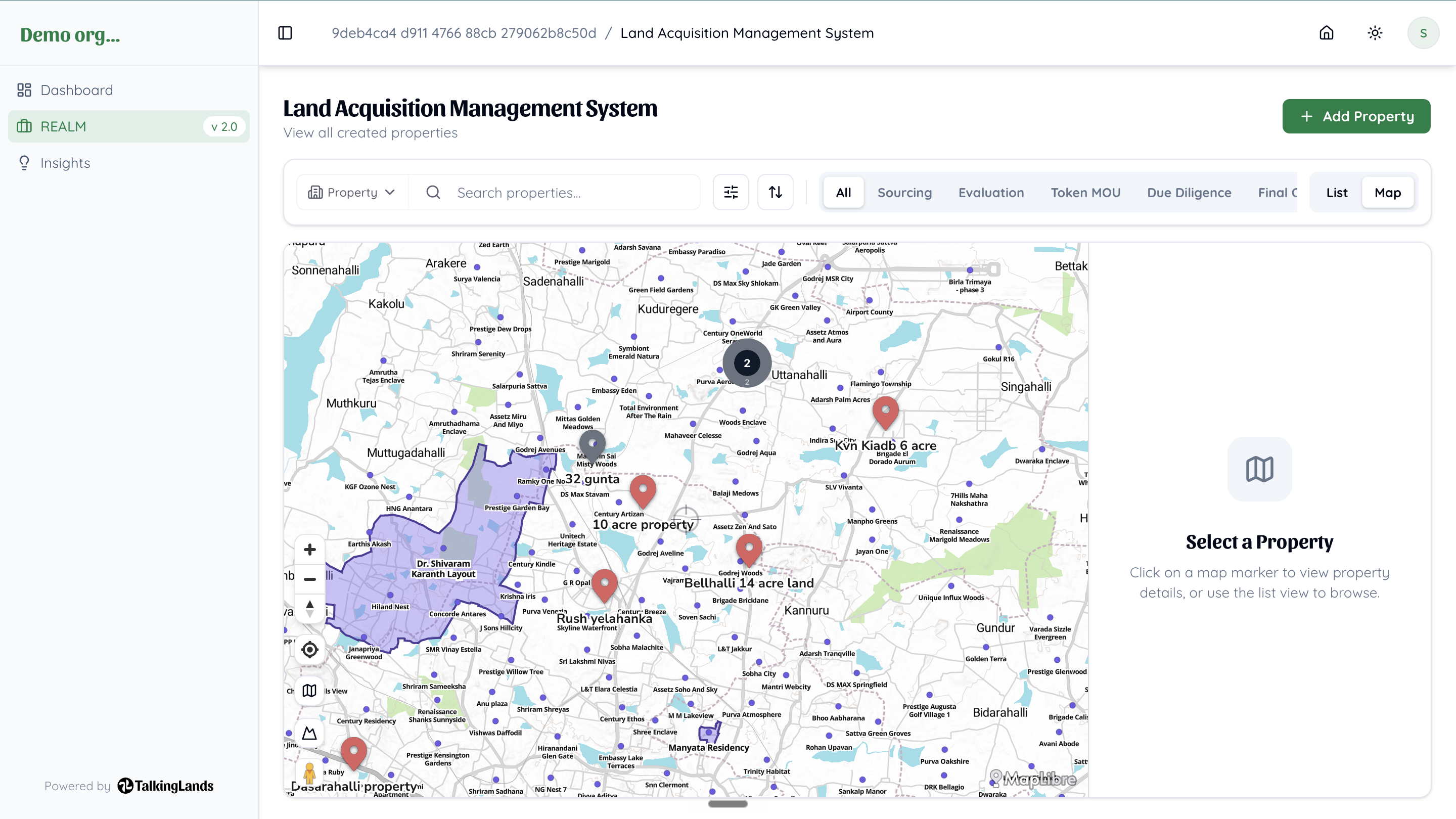
REALM is a purpose-built B2B spatial deal room engineered specifically for institutional acquirers. While distinct from standalone lease or satellite-encroachment software, REALM uniquely unifies the most critical elements of land portfolio building:
Spatial Sourcing & Intelligence: Instantly overlay your portfolio against Master Plan zoning, infrastructure corridors, and environmental risk buffers.
Title & Ownership Records: Centralize live revenue records and ownership intelligence directly tied to the spatial boundaries.
Litigation Tracking: Monitor parcels for active civil court cases and legal risks.
Acquisition & Portfolio Pipeline: Manage the end-to-end lifecycle—from the initial broker negotiation to the finalized holding portfolio—on one unified, secure dashboard.
TalkingLands REALM
Manage Your Entire Land Portfolio on One Platform
REALM unifies spatial sourcing, title & ownership intelligence, litigation checks, and pipeline management — so you can aggregate and manage parcels at scale without spreadsheet chaos.
Land management software is an enterprise GIS (Geographic Information System) and MIS platform designed to digitize, map, and govern a company’s land portfolio. It centralizes land records, monitors encroachment, tracks leases and compliance, and provides real-time portfolio valuation.
2. What is the difference between land management and land acquisition software?
Land Acquisition Management Software (LAMS) focuses on the "Buy Side"—managing broker leads, due diligence, and the aggregation pipeline before the land is purchased. Land Management Software focuses on the "Hold Side"—maintaining the asset, tracking leases, and monitoring encroachment after the land is registered.
3. What are the key features of an enterprise land management system?
Core modules typically include GIS parcel mapping, a digitized land records vault (for deeds and revenue extracts), ownership and litigation tracking, lease and asset management, compliance monitoring (property taxes, NA conversions), and spatial encroachment tracking.
4. Who uses land management software in India?
It is utilized by tier-1 real estate developers holding large land banks, infrastructure and industrial firms managing plant footprints, Public Sector Undertakings (PSUs), government land departments, and REITs.
5. Does land management software detect physical encroachment?
Many advanced category solutions integrate periodic satellite imagery or drone mapping. By overlaying fresh imagery onto the authorized GIS parcel boundary, portfolio managers can visually detect illegal boundary shifts, logging, or squatter structures without deploying physical teams.
6. How do I choose the best land software for my enterprise?
Evaluate platforms based on their ability to handle Indian cadastral structures (Survey/Gat numbers), their integration of live state revenue records, spatial intelligence layers (zoning and infrastructure overlays), and enterprise-grade data security to protect sensitive title documents.
.png)
.png)



.png)
.png)

.png)
