.png)
A buyer pays a massive premium for a beautiful riverside plot in Pune, envisioning a luxury home with uninterrupted views of the Mula-Mutha river. They finalize the sale, clear the title, and begin preparing the foundation.
Then the monsoon arrives. Heavy rains force the irrigation department to release water from the Khadakwasla dam, and the river violently breaches its banks. The buyer's plot is entirely submerged. In the aftermath, when they try to claim insurance or secure a building permit to restart, they hit a regulatory brick wall: the plot sits squarely inside the river's Blue Line.
Construction was never legally permitted there in the first place. The buyer is now trapped with an unauthorized, uninsurable, and un-regularizable asset.
With the devastating monsoon floods that struck Pune in 2024 and 2025, the reality of climate risk has finally caught up to the real estate market. Buying a "river-view" property without executing a spatial flood-line check is a catastrophic financial risk. Here is your complete 2026 guide to understanding the blue and red flood lines, exactly where you are legally allowed to build, and how to digitally verify a plot before you pay the premium.
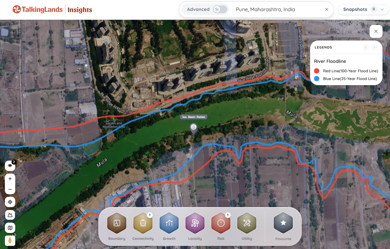
Quick Answer: The Maharashtra Water Resources Department demarcates two statutory flood lines along rivers: the Blue Line (representing the 25-year maximum flood) and the Red Line (representing the 100-year maximum flood). The area inside the blue line is the Prohibitive Zone—absolutely no residential or commercial construction is allowed. The area between the blue and red lines is the Restrictive Zone—construction is strictly limited and heavily conditioned. Land situated safely outside the red line is generally developable. Always overlay a plot's coordinates against the official flood lines before buying land near any Pune river.
Rivers do not have fixed physical borders; their banks expand and contract based on rainfall and dam discharges. To protect citizens and urban infrastructure, the Maharashtra Water Resources Department (WRD) / Irrigation Department issues guidelines (stemming from a landmark 1989 circular) to map the potential inundation bands of rivers.
Engineers simulate historical flood data and dam spillway discharges, then draw two critical boundary lines on topographical maps:
.png)
Pune is defined by its waterways—the Mula, Mutha, and Pavana rivers. Over the last decade, rapid urbanization resulted in massive unauthorized encroachments into the riverbeds.
During the severe monsoons of 2024 and 2025, areas along Sinhagad Road (like Ekta Nagari) and Bopodi faced devastating inundation. Dam water releases paralyzed neighborhoods that were structurally built inside danger zones. Consequently, citizens, environmentalists, and PMC-appointed committees have demanded a ruthless crackdown on illegal riverside construction.
The Re-Survey Reality: The government and the Pune Municipal Corporation (PMC) are actively scrutinizing and re-surveying historical flood lines. A plot that a developer claimed was "safe" on an outdated 1990s PDF map might officially fall inside the blue line on today's digitized topographical surveys. You must verify against the latest, active data.
This is the most dangerous zone. By law, no structure that obstructs the natural flow of water can be built here. The land can only be utilized for open-to-sky purposes like farming, public gardens, or playgrounds. If you buy a plot here to build a house, the municipal corporation will reject your building plan. If a builder constructs an apartment block here anyway, it is an illegal structure liable for demolition.
This area will flood, but less frequently (theoretically once every 25 to 100 years). Development is allowed, but it is heavily restricted.
When evaluating riverside property in Pune, avoid these devastating errors:
To protect your capital, you must bridge the gap between the physical plot and the government's topographical data.
Traditionally, this meant taking your Survey/Gat Number, visiting the local PMC office or Irrigation Department, and requesting an engineer to manually plot your parcel against locked-away maps.
Today, you can execute this verification digitally using TalkingLands Insights (Pune).Drop your Gat Number into the platform to visualize the plot on a live map. Activate the Risk → River Floodline Layer to instantly overlay the 25-year (Blue) and 100-year (Red) flood lines. You can immediately see if your plot sits in the Prohibitive Zone, the Restrictive Zone, or safe developable land. Simultaneously, you can check the PMRDA zoning and—for covered villages—view the 7/12 Extract (Satbara) parcel boundaries to ensure complete spatial safety.
(Honesty Note: While the Insights platform reflects digitized, mapped flood-line data to help you evaluate risk, the legally binding demarcation remains the exclusive domain of the Irrigation Department and PMC. Always secure official municipal clearance before commencing construction).
These are statutory flood lines demarcated by the Maharashtra Water Resources Department to prevent loss of life and property. The Blue Line represents the maximum flood discharge level expected once in 25 years. The Red Line represents the maximum flood level expected once in 100 years.
No. The area inside the Blue Line is legally classified as a Prohibitive Zone. Absolutely no residential, commercial, or structural construction that obstructs the natural flow of water is allowed. It is strictly reserved for open-to-sky uses like farming, playgrounds, or public gardens.
The Restrictive Zone is the band of land located between the Blue Line and the Red Line. Development is permitted here, but it is subject to severe municipal conditions, such as building the habitable ground floor on an elevated plinth above the maximum flood level and a strict prohibition on basement parking.
The Blue Line defines the area of frequent, high-risk flooding (25-year return period) where no private structures can be built. The Red Line defines a less frequent, extreme flood scenario (100-year return period). Land beyond the Red Line is generally considered safe and fully developable.
Yes. Following devastating monsoon floods in recent years across areas like Sinhagad Road and Bopodi, the Pune Municipal Corporation (PMC) and the Irrigation Department are under immense pressure to scrutinize, re-survey, and strictly enforce flood-line demarcations to prevent further riverbed encroachments.
Do not rely on outdated paper maps or verbal assurances from brokers. You should digitally overlay your exact Survey/Gat Number against the mapped flood lines using spatial intelligence platforms like TalkingLands Insights. For absolute legal certainty before construction, you must obtain formal clearance from the PMC or the Irrigation Department.



.png)

.png)
