%20(1).png)
TOD Zones in Pune (2026): Higher FSI Near Metro Stations & How to Check
A developer aggressively acquires a 2-acre plot marketed as being "near the Hinjewadi metro," eager to capitalize on the highly publicized TOD zone Pune policies. Expecting to utilize the higher Floor Space Index (FSI) allowed near transit hubs, they project a massive luxury high-rise capable of yielding a 35% IRR.
When they submit their blueprints to the planning authority, the project is instantly rejected. The architect delivers the devastating news: the plot sits 520 meters away from the metro station boundary. Because it falls just 20 meters outside the official 500m Transit-Oriented Development (TOD) line, it is only eligible for standard base FSI. The developer is legally restricted from building the extra floors they budgeted for, and the entire financial economics of the project collapse. Had the plot been just one street closer, they could have built 2 to 3 times more saleable area.
In Pune's rapidly expanding real estate market, proximity to a metro station does not automatically guarantee higher development potential. You must be precisely inside the notified legal boundary. Here is your complete 2026 guide to Pune's TOD zones, how the massive FSI uplift works, which corridors qualify, and how to digitally verify a plot’s TOD status before committing your capital.
Quick Answer: A TOD (Transit-Oriented Development) zone is a designated area—typically within a ~500-meter radius of an official metro station boundary—where the government permits significantly higher Floor Space Index (FSI). Under the Unified Development Control and Promotion Regulations (UDCPR) and local DCPR, developers inside this zone can achieve a total FSI of up to ~4.0 (compared to the much lower base FSI outside the zone), allowing for taller, higher-density, mixed-use buildings. In Pune, this applies around notified stations across Lines 1, 2, and the Line 3 Hinjewadi–Shivajinagar corridor. Being inside versus outside this 500m line drastically dictates what you can build. Always verify a plot's exact spatial status before buying.
What is a TOD Zone?
Transit-Oriented Development (TOD) is an urban planning strategy designed to concentrate maximum population and employment density within walking distance of high-capacity mass transit (like the Pune Metro).
Instead of allowing cities to endlessly sprawl outward, the government encourages developers to build vertically around transit hubs.
- The Radius: In Maharashtra, the TOD zone is generally defined as the area falling within a ~500-meter radius from the physical boundary of a proposed or existing metro station.
- The Governance: The policy is governed by local planning authorities like the Pune Municipal Corporation (PMC) and the Pune Metropolitan Region Development Authority (PMRDA), guided by the UDCPR (Unified Development Control and Promotion Regulations) and specific state TOD notifications (first formally inserted into the Pune DCPR around 2017).
Inside vs. Outside a Pune TOD Zone
.png)
The FSI Advantage (The Money Angle)
Floor Space Index (FSI) dictates the total built-up area you can construct relative to your plot size. The entire financial logic of buying in a TOD zone rests on this multiplier.
- Base FSI vs. TOD FSI: A standard plot in Pune might have a base FSI of 1.10. Under the TOD policy, if that same plot sits inside the 500m radius and fronts a sufficiently wide road, the maximum permissible FSI can be pushed up to ~4.0.
- What This Means for Returns: If you own a 10,000 sq. ft. plot, a standard FSI might limit you to constructing ~11,000 sq. ft. of saleable area. In a TOD zone with 4.0 FSI, you can construct up to 40,000 sq. ft. of saleable area. This exponential increase in inventory allows developers to easily absorb higher land acquisition costs.
- The Catch (The Conditions): The higher FSI is not handed out for free. To utilize the maximum 4.0 FSI, your plot must typically front a wide road (usually 15 meters or wider). Additionally, anything built above the base FSI must be purchased from the municipal authority by paying a substantial Premium FSI charge. The authorities use this premium revenue to fund the massive capital costs of the metro infrastructure itself.
(Note: Exact FSI calculations, road width prerequisites, and premium rates are strictly subject to the current UDCPR/DCPR provisions in force. Always verify the latest schedules with a registered architect).
Which Pune Corridors & Stations Qualify?
The TOD policy applies selectively to officially notified mass transit corridors.
- The Hinjewadi–Shivajinagar Corridor (Line 3): This is the most aggressively sought-after TOD belt in Pune. The state government officially approved the TOD zone for this PMRDA-led corridor, inviting massive institutional investments in Balewadi, Baner, and Hinjewadi.
- PCMC to Swargate (Line 1) & Vanaz to Ramwadi (Line 2): The TOD policy was historically sanctioned for these primary Maha-Metro corridors, sparking intense redevelopment of older housing societies in areas like Kothrud, Karve Nagar, and Deccan.
Critical Rule: A TOD zone only exists around notified stations. If the government proposes a metro extension but has not yet formally gazetted the station boundaries and TOD applicability, you cannot legally claim the higher FSI.
How to Check if a Plot is in a TOD Zone
Do not rely on a broker pacing out the distance or pointing to a distant metro pillar. You must verify the plot's spatial geometry against the government's official demarcations.
- Identify the Station Boundary: The 500m radius is generally measured from the outer physical boundary of the station structure, not the center of the tracks.
- Review Official TOD Maps: The PMC and PMRDA maintain sanctioned TOD overlay maps. If your plot sits on the edge (e.g., 50% inside the 500m line and 50% outside), the UDCPR dictates specific proportional FSI calculations.
- Check the PMRDA Development Plan: Ensure your plot is actually zoned for development. A plot inside a TOD radius that falls on a reserved public park or water body cannot be built upon, regardless of the metro's proximity.
The Traps (Common Mistakes)
Buyers frequently hemorrhage capital by failing to understand the technicalities of TOD policies:
- Assuming "Near Metro" Equals TOD: A plot located 600 meters from the station is highly attractive for commuters, but it is legally outside the TOD zone. It will not receive the 4.0 FSI multiplier. You are paying a transit premium without getting the regulatory upside.
- Ignoring Road Width Conditions: You find a plot 200 meters from a station, perfectly inside the TOD zone. However, it sits on a narrow 6-meter lane. Under the UDCPR, maximum FSI is heavily restricted on narrow roads to prevent severe traffic bottlenecks. You will not get 4.0 FSI here.
- Buying on Unsanctioned Stations: Speculating on a "proposed" future metro station is dangerous. Until the state government formally notifies the station and the accompanying TOD zone, the 500m radius rule does not legally exist.
- Fragmented Titles: Even with 4.0 FSI, a developer cannot secure RERA approval or bank funding if the land has undisclosed heirs or title defects. A flawless 7/12 Extract (Satbara) is mandatory before exploiting TOD potential.
Verify TOD Status Instantly with TalkingLands Insights
You cannot confirm if a plot is safely inside the 500m radius or verify its road access by simply trusting a sales brochure.
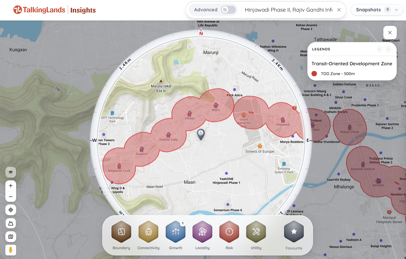
With TalkingLands Insights (Pune), checking your plot takes seconds.Drop your Gat Number into the platform to visualize the property on a live satellite map. Activate the TOD Zone Layer (confirmed live on key corridors like Hinjewadi) to instantly see the glowing 500m radius around the metro station boundary and verify if your plot falls inside it. You can simultaneously toggle the Master Plan Layer to check base zoning and view major highway/ring road connections on one screen.
(Honesty Note: While the Insights platform reflects digitized TOD radius data to help you evaluate FSI potential, the legally binding boundary is the sanctioned PMC/PMRDA TOD map. Always confirm exact FSI entitlements with a registered architect based on the latest UDCPR).
%20(1)-p-2000.png)
Frequently Asked Questions
1. What is a TOD zone in Pune?
Transit-Oriented Development (TOD) is an urban planning zone designated within a ~500-meter radius of an official Pune Metro station. It is designed to promote high-density, mixed-use development by offering developers significantly higher building allowances near public transit hubs.
2. How much FSI is allowed in a TOD zone?
Under the current UDCPR and local municipal regulations, developers can achieve a maximum permissible FSI of up to ~4.0 within a notified TOD zone. This is a massive increase over standard base FSI, though it requires payment of premium charges to the government.
3. What is the standard TOD radius in Maharashtra?
The standard transit influence zone is generally demarcated as a 500-meter radius measured from the physical boundary of the notified metro station, subject to exact municipal alignment maps.
4. Which Pune metro corridors have TOD policies applied?
The state government has approved TOD zones for the PMRDA-led Hinjewadi–Shivajinagar corridor (Line 3), as well as the primary Maha-Metro corridors from PCMC to Swargate (Line 1) and Vanaz to Ramwadi (Line 2).
5. Is "near the metro" the same thing as being in a TOD zone?
No. A property can be a 10-minute walk from the metro (e.g., 700 meters away) and highly attractive to renters, but it will fall outside the legal 500m TOD zone. Such a plot will not receive the 4.0 FSI multiplier, severely limiting its development scale.
6. How can I check if a plot is inside a TOD zone before buying?
You must map the exact survey or Gat number against the official PMC/PMRDA 500m radius maps. Using spatial intelligence platforms like TalkingLands Insights, you can digitally overlay your property boundary against the active TOD Zone layer to verify its exact distance from the station.
.png)

.png)


